Bassillon-Vauzé
| Bassillon-Vauzé | |
|---|---|
|
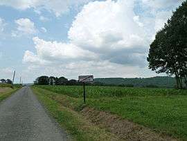
The Entrance to the commune | |
 Bassillon-Vauzé | |
|
Location within Nouvelle-Aquitaine region  Bassillon-Vauzé | |
| Coordinates: 43°27′27″N 0°04′27″W / 43.4575°N 0.0742°WCoordinates: 43°27′27″N 0°04′27″W / 43.4575°N 0.0742°W | |
| Country | France |
| Region | Nouvelle-Aquitaine |
| Department | Pyrénées-Atlantiques |
| Arrondissement | Pau |
| Canton | Lembeye |
| Intercommunality | Canton de Lembeye en Vic-Bilh |
| Government | |
| • Mayor (2014–2020) | Claude Lagarrue |
| Area1 | 4.96 km2 (1.92 sq mi) |
| Population (2010)2 | 72 |
| • Density | 15/km2 (38/sq mi) |
| Time zone | CET (UTC+1) |
| • Summer (DST) | CEST (UTC+2) |
| INSEE/Postal code | 64098 / 64350 |
| Elevation |
190–303 m (623–994 ft) (avg. 211 m or 692 ft) |
|
1 French Land Register data, which excludes lakes, ponds, glaciers > 1 km² (0.386 sq mi or 247 acres) and river estuaries. 2 Population without double counting: residents of multiple communes (e.g., students and military personnel) only counted once. | |
Bassillon-Vauzé is a French commune of the Pyrénées-Atlantiques department in the Nouvelle-Aquitaine region of south-western France.[1]
Geography
Bassillon-Vauzé is located some 25 km north-east of Pau and 8 km west of Maubourguet. The eastern border of the commune is also the departmental border with Hautes-Pyrénées. Access to the commune is by the D68 from Vidouze in the east which changes to the D148 at the departmental border and continues through the south of the commune west to join the D943 south-west of the commune. The D205 comes from Corbère-Abères in the north which passes through the commune and continues south to join the D148 in the south of the commune. The commune is mostly farmland with some forest in the west.[2][3]
The Larcis river and the Lac de Bassillon, which is formed by a dam on the Larcis, form the eastern border of the commune. The Ruisseau du Boscq forms the western border of the commune as it flows north into the lake formed by the Retenue de Lembeye-Corbères dam.[2][3]
Places and Hamlets

Mapping
A list of online mapping systems can be displayed by clicking on the coordinates (latitude and longitude) in the top right hand corner of this article.
Neighbouring communes and villages
 |
Escurès | Corbère-Abères | Moncaup | |
| Lembeye | |
Lahitte-Toupière | ||
| ||||
| | ||||
| Samsons-Lion | Luc-Armau | Vidouze |
Toponymy
Michel Grosclaude said that Bassillon comes from the Latin name Bassilius with the suffix -onem, giving "Domain of Bassius". The origin of Vauzé is undetermined.[6]
The following table details the origins of the commune name and other names in the commune.
| Name | Spelling | Date | Source | Page | Origin | Description |
|---|---|---|---|---|---|---|
| Bassillon | Basilhoo | 1385 | Grosclaude | Census | Village | |
| Basilhoo | 1402 | Raymond | Census | |||
| Bacilhoo | 1540 | Raymond | Reformation | |||
| Baxilho | 1542 | Raymond | Reformation | |||
| Basilhon | 1546 | Raymond | Reformation | |||
| Bacilhon | 1550 | Raymond | Reformation | |||
| Baßillon | 1750 | Cassini | ||||
| Bassillon | 1790 | Cassini1 | ||||
| Vauzé | Bauser | 1385 | Grosclaude | Census | Village | |
| Bausee | 1538 | Raymond | Reformation | |||
| Bauser | 1538 | Raymond | Reformation | |||
| Beauzé | 1675 | Raymond | Reformation | |||
| Vauzer | 1682 | Raymond | Reformation | |||
| Vauzé | 1750 | Cassini | ||||
| Vauser | 1768 | Raymond | Denombrement | |||
| Vauzé | 1790 | Cassini1 | Reformation | |||
| Le Castet | Le Castet | 1863 | Raymond | Farm | ||
| Le Moutha | Le Moutha | 1863 | Raymond | Place | ||
| Moutoné | Mountouné | 1774 | Raymond | Terrier of Bassillon | Place |
Sources:
- Grosclaude: Toponymic Dictionary of communes, Béarn, 2006 (French)[6]
- Raymond: Topographic Dictionary of the Department of Basses-Pyrenees, 1863, on the page numbers indicated in the table. (French)[4]
- Cassini: 1750 Cassini Map[7]
- Cassini1: 1790 Cassini Map[8]
Origins:
- Census: Census of Béarn[9]
- Reformation: Reformation of Béarn[10]
- Denombrement: Denombremont of Candau[11]
History
Paul Raymond noted on page 23 of his 1863 dictionary that in 1385 Bassillon had 7 fires and depended on the bailiwick of Lembeye. On page 173 he mentioned that Vauzé had a lay abbey, vassal of the Viscount of Vauzé, and that the Barony of Vauzé was created in 1641 under the Viscounts of Béarn which included Peyrelongue-Abos and Vauzé.[4]
The former communes of Bassillon and Vauzé were merged in 1833.
Administration
| From | To | Name | Party | Position |
|---|---|---|---|---|
| 1995 | 2014 | Jean-Claude Maury | ||
| 2014 | 2020 | Claude Lagarrue |
(Not all data is known)
Inter-communality
The commune is part of four inter-communal structures:
- the Community of communes of the canton of Lembeye in Vic-Bilh;
- the SIVU for roads in the canton of Lembeye;
- the Energy association of Pyrénées-Atlantiques;
- the inter-communal association for the supply of drinking water of Vic-Bilh Montanérès;
Demography
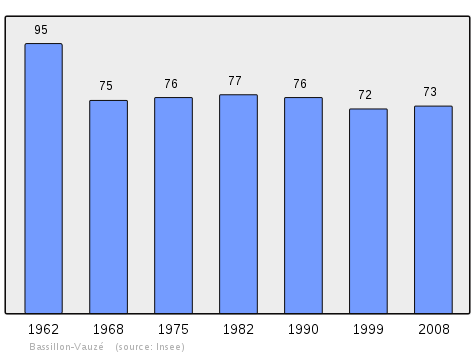
In 2010 the commune had 72 inhabitants. The evolution of the number of inhabitants is known from the population censuses conducted in the commune since 1793. From the 21st century, a census of communes with fewer than 10,000 inhabitants is held every five years, unlike larger communes that have a sample survey every year.[Note 1]
| 1793 | 1800 | 1806 | 1821 | 1831 | 1836 | 1841 | 1846 | 1851 |
|---|---|---|---|---|---|---|---|---|
| 132 | 130 | 555 | 150 | 286 | 284 | 287 | 240 | 241 |
| 1856 | 1861 | 1866 | 1872 | 1876 | 1881 | 1886 | 1891 | 1896 |
|---|---|---|---|---|---|---|---|---|
| 233 | 203 | 218 | 205 | 190 | 188 | 180 | 167 | 161 |
| 1901 | 1906 | 1911 | 1921 | 1926 | 1931 | 1936 | 1946 | 1954 |
|---|---|---|---|---|---|---|---|---|
| 178 | 164 | 169 | 134 | 115 | 109 | 109 | 108 | 99 |
| 1962 | 1968 | 1975 | 1982 | 1990 | 1999 | 2006 | 2010 | - |
|---|---|---|---|---|---|---|---|---|
| 95 | 75 | 76 | 77 | 76 | 72 | 72 | - |
Sources : Ldh/EHESS/Cassini until 1962, INSEE database from 1968 (population without double counting and municipal population from 2006)

Economy
The commune is located in the appellation d'origine contrôlée (AOC) zone of Pacherenc-du-vic-bilh white wine.
Culture and heritage

Civil heritage
The commune has a number of buildings and sites that are registered as historical monuments:
- The Maison Laïus Farmhouse (1765)
 [5]
[5] - Houses and Farms (18th-19th century)[13]
- A Fountain (1833)[14]
- A Fortified Complex (Prehistoric)[15]
Religious heritage
The commune has several religious buildings and sites that are registered as historical monuments:
- A Presbytery (1853)[16]
- The Parish Church of Saint Girons at Bassillon (1783)[17] The Church contains several items that are registered as historical objects:
- The Parish Church of Saint-Barthélémy at Vauzé (1773)[23] The Church contains several items that are registered as historical objects:
- A Stations of the Cross (19th century)
 [24]
[24] - 4 Altar Candlesticks (18th century)[25]
- A Stoup (18th century)[26]
- A Stations of the Cross (19th century)
See also
Notes and references
Notes
- ↑ At the beginning of the 21st century, the methods of identification have been modified by Law No. 2002-276 of 27 February 2002, the so-called "law of local democracy" and in particular Title V "census operations" allows, after a transitional period running from 2004 to 2008, the annual publication of the legal population of the different French administrative districts. For communes with a population greater than 10,000 inhabitants, a sample survey is conducted annually and the entire territory of these communes is taken into account at the end of the period of five years. The first "legal population" after 1999 under this new law came into force on 1 January 2009 and was based on the census of 2006.
References
- ↑ Bassillon-Vauzé on Lion1906
- 1 2 3 Bassillon-Vauzé on Google Maps
- 1 2 Bassillon-Vauzé on the Géoportail from National Geographic Institute (IGN) website (French)
- 1 2 3 4 Topographic Dictionary of the Department of Basses-Pyrenees, Paul Raymond, Imprimerie nationale, 1863, Digitised from Lyon Public Library 15 June 2011 (French)
- 1 2 Ministry of Culture, Mérimée IA00026458 Maison Laïus Farmhouse (French)
- 1 2 Michel Grosclaude, Toponymic Dictionary of communes, Béarn, Edicions reclams & Édition Cairn - 2006, 416 pages, ISBN 2-35068-005-3(French)
- ↑ Baßillon and Vauzé on the 1750 Cassini Map
- ↑ Bassillon and Vauzé on the 1790 Cassini Map
- ↑ Manuscript from the 14th century - Departmental Archives of Pyrénées-Atlantiques (French)
- ↑ Manuscript from the 16th to 18th centuries - Departmental Archives of Pyrénées-Atlantiques (French)
- ↑ Manuscripts from the 17th and 18th centuries in the Departmental Archives of Pyrénées-Atlantiques (French)
- ↑ List of Mayors of France (French)
- ↑ Ministry of Culture, Mérimée IA00026457 Houses and Farms (French)
- ↑ Ministry of Culture, Mérimée IA00026454 Fountain (French)
- ↑ Ministry of Culture, Mérimée IA00026450 Fortified Complex (French)
- ↑ Ministry of Culture, Mérimée IA00026459 Presbytery (French)
- ↑ Ministry of Culture, Mérimée IA00026456 Parish Church of Saint Girons (French)
- ↑ Ministry of Culture, Palissy IM64002146 2 Statues (French)
- ↑ Ministry of Culture, Palissy IM64002145 Pulpit (French)
- ↑ Ministry of Culture, Palissy IM64002144 2 Stoups (French)
- ↑ Ministry of Culture, Palissy IM64002143 Stoup (French)
- ↑ Ministry of Culture, Palissy IM64002142 Stained glass windows (French)
- ↑ Ministry of Culture, Mérimée IA00026455 Parish Church of Saint-Barthélémy (French)
- ↑ Ministry of Culture, Palissy IM64002149 Stations of the Cross (French)
- ↑ Ministry of Culture, Palissy IM64002148 4 Altar Candlesticks (French)
- ↑ Ministry of Culture, Palissy IM64002147 Stoup (French)
| Wikimedia Commons has media related to Bassillon-Vauzé. |