Aline, Oklahoma
| Aline, Oklahoma | |
|---|---|
| Town | |
 Location of Aline, Oklahoma | |
| Coordinates: 36°30′35″N 98°26′56″W / 36.50972°N 98.44889°WCoordinates: 36°30′35″N 98°26′56″W / 36.50972°N 98.44889°W[1] | |
| Country | United States |
| State | Oklahoma |
| County | Alfalfa |
| Area | |
| • Total | 0.3 sq mi (0.7 km2) |
| • Land | 0.3 sq mi (0.7 km2) |
| • Water | 0.0 sq mi (0.0 km2) |
| Elevation[1] | 1,289 ft (393 m) |
| Population (2010) | |
| • Total | 207 |
| • Estimate (2015)[2] | 219 |
| • Density | 788/sq mi (304.4/km2) |
| Time zone | Central (CST) (UTC-6) |
| • Summer (DST) | CDT (UTC-5) |
| ZIP code | 73716 |
| Area code(s) | 580 |
| FIPS code | 40-01350[3] |
| GNIS feature ID | 1089583[1] |
Aline is a town in Alfalfa County, Oklahoma, United States. The population was 207 at the 2010 census.[4]
History
The Choctaw Northern railway (later owned by the Chicago, Rock Island and Pacific[5]), became the county's first railroad in 1901, connecting Aline to the other Alfalfa county towns of Augusta, Ingersoll, Lambert, Driftwood, Amorita, and on into Kansas.[6]
Geography
According to the United States Census Bureau, the town has a total area of 0.263 square miles (0.68 km2), all of it land.[7]
Aline is connected to the state highway system via State Highway 8B. The town lies at the western terminus of the highway.[8]
Demographics
| Historical population | |||
|---|---|---|---|
| Census | Pop. | %± | |
| 1910 | 303 | — | |
| 1920 | 358 | 18.2% | |
| 1930 | 429 | 19.8% | |
| 1940 | 405 | −5.6% | |
| 1950 | 385 | −4.9% | |
| 1960 | 314 | −18.4% | |
| 1970 | 260 | −17.2% | |
| 1980 | 313 | 20.4% | |
| 1990 | 295 | −5.8% | |
| 2000 | 214 | −27.5% | |
| 2010 | 207 | −3.3% | |
| Est. 2015 | 219 | [2] | 5.8% |
As of the census of 2010, there were 207 people residing in the town.[10] The population density was 813.3 people per square mile (317.8/km²). There were 123 housing units at an average density of 480 per square mile (187/km²).[10] The racial makeup of the town was 95.79% White, 0.93% Native American, 0.47% from other races, and 2.80% from two or more races. Hispanic or Latino of any race were 1.40% of the population.
There were 101 households out of which 18.8% had children under the age of 18 living with them, 53.5% were married couples living together, 6.9% had a female householder with no husband present, and 36.6% were non-families. 35.6% of all households were made up of individuals and 22.8% had someone living alone who was 65 years of age or older. The average household size was 2.12 and the average family size was 2.69.
In the town the population was spread out with 18.2% under the age of 18, 11.2% from 18 to 24, 21.5% from 25 to 44, 26.2% from 45 to 64, and 22.9% who were 65 years of age or older. The median age was 45 years. For every 100 females there were 103.8 males. For every 100 females age 18 and over, there were 101.1 males.
The median income for a household in the town was $25,556, and the median income for a family was $28,333. Males had a median income of $26,500 versus $17,083 for females. The per capita income for the town was $12,710. About 22.4% of families and 24.1% of the population were below the poverty line, including 21.1% of those under the age of eighteen and 33.3% of those sixty five or over.
Notable residents
- Harold G. Kiner (April 14, 1924 – October 2, 1944), United States Army Medal of Honor winner born here
Historical Artifact
- Aline is home to the Sod House Museum[11] The museum encloses an original sod house, the only one still standing in Oklahoma that was built by a homesteader.
References
- 1 2 3 "Feature Detail Report for: Goltry (populated place)". Geographic Names Information System(GNIS). United States Geological Survey. December 18, 1979. Retrieved September 1, 2016.
- 1 2 "Annual Estimates of the Resident Population for Incorporated Places: April 1, 2010 to July 1, 2015". Retrieved July 2, 2016.
- ↑ "American FactFinder". United States Census Bureau. Archived from the original on September 11, 2013. Retrieved January 31, 2008.
- ↑ "Geographic Identifiers: 2010 Demographic Profile Data (G001): Aline town, Oklahoma". U.S. Census Bureau, American Factfinder. Retrieved July 15, 2013.
- ↑ Everett, Dianna. "Encyclopedia of Oklahoma History and Culture - Amorita". Encyclopedia of Oklahoma History and Culture. Oklahoma History Center. Retrieved July 7, 2016.
- ↑ Everett, Dianna. "Encyclopedia of Oklahoma History and Culture - Alfalfa County". Encyclopedia of Oklahoma History and Culture. Oklahoma History Center. Retrieved July 7, 2016.
- ↑ "US Gazetteer files: 2010 (Oklahoma)". United States Census Bureau. February 12, 2011. Retrieved September 1, 2016.
- ↑ Oklahoma 2009-2010 Official State Map (PDF) (Map) (2009-2010 ed.). Oklahoma Department of Transportation. Retrieved August 31, 2016.
- ↑ "Census of Population and Housing". Census.gov. Archived from the original on May 11, 2015. Retrieved June 4, 2015.
- 1 2 "2010 City Population and Housing Occupancy Status". U.S. Census Bureau. Archived from the original on July 21, 2011. Retrieved October 18, 2013.
- ↑ http://www.okhistory.org/sites/sodhouse.php
External links
Municipalities and communities of Alfalfa County, Oklahoma, United States | ||
|---|---|---|
| City | 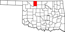 | |
| Towns | ||
| CDP | ||
| Other unincorporated communities | ||