Alincourt
| Alincourt | |
|---|---|
|
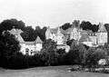
The Town Hall | |
 Alincourt | |
|
Location within Grand Est region  Alincourt | |
| Coordinates: 49°24′16″N 4°20′45″E / 49.4044°N 4.3458°ECoordinates: 49°24′16″N 4°20′45″E / 49.4044°N 4.3458°E | |
| Country | France |
| Region | Grand Est |
| Department | Ardennes |
| Arrondissement | Rethel |
| Canton | Juniville |
| Intercommunality | Pays rethélois |
| Government | |
| • Mayor (2008–2020) | Joël de Carlini |
| Area1 | 8.62 km2 (3.33 sq mi) |
| Population (2009)2 | 137 |
| • Density | 16/km2 (41/sq mi) |
| Time zone | CET (UTC+1) |
| • Summer (DST) | CEST (UTC+2) |
| INSEE/Postal code | 08005 / 08310 |
| Elevation |
83–141 m (272–463 ft) (avg. 102 m or 335 ft) |
|
1 French Land Register data, which excludes lakes, ponds, glaciers > 1 km² (0.386 sq mi or 247 acres) and river estuaries. 2 Population without double counting: residents of multiple communes (e.g., students and military personnel) only counted once. | |

Alincourt is a French commune in the Ardennes department in the Grand Est region of northern France.
The inhabitants of the commune are known as Alincourtois or Alincourtoises[1]
Geography
Alincourt is located some 15 km south of Rethel and 25 km north-east of Rheims. It can be accessed on the D925 road from Neuflize in the west passing through the heart of the commune and the village and continuing east to Juniville. The D985 road from Perthes in the north also passes through the north-west of the commune and continues to join the D925 west of Juniville. The commune consists entirely of farmland other than a strip of forest along the banks of the river.[2]
The Retourne river flows through the commune from east to west passing just south of the village and continuing west until it joins the Aisne at Neufchatel-sur-Aisne.[2]
Neighbouring communes and villages[2]
 |
Tagnon | Perthes | Annelles | |
| Neuflize | |
Juniville | ||
| ||||
| | ||||
| Isles-sur-Suippe | Aussonce | La Neuville-en-Tourne-à-Fuy |
Administration
List of Successive Mayors[3]
| From | To | Name | Party | Position |
|---|---|---|---|---|
| 1833 | 1837 | Paul Damien Hainguerlot | ||
| 1837 | 1841 | Jean Paul Hainguerlot | ||
| 1841 | 1842 | Noêl Flandre | ||
| 1983 | 2001 | Hilaire Flandre | ||
| 2001 | 2008 | Claude Olette | ||
| 2008 | 2020 | Joël de Carlini |
(Not all data is known)
Demography
In 2009 the commune had 137 inhabitants. The evolution of the number of inhabitants is known through the population censuses conducted in the commune since 1793. From the 21st century, a census of communes with fewer than 10,000 inhabitants is held every five years, unlike larger towns that have a sample survey every year.[Note 1]
| 1793 | 1800 | 1806 | 1821 | 1831 | 1836 | 1841 | 1846 | 1851 |
|---|---|---|---|---|---|---|---|---|
| 244 | 253 | 260 | 266 | 316 | 345 | 336 | 355 | 360 |
| 1856 | 1861 | 1866 | 1872 | 1876 | 1881 | 1886 | 1891 | 1896 |
|---|---|---|---|---|---|---|---|---|
| - | - | 315 | 282 | 268 | 229 | 235 | 215 | 187 |
| 1901 | 1906 | 1911 | 1921 | 1926 | 1931 | 1936 | 1946 | 1954 |
|---|---|---|---|---|---|---|---|---|
| 198 | 185 | 168 | 118 | 117 | 122 | 121 | 101 | 114 |
| 1962 | 1968 | 1975 | 1982 | 1990 | 1999 | 2006 | 2009 | - |
|---|---|---|---|---|---|---|---|---|
| 114 | 85 | 79 | 86 | 91 | 78 | 100 | 137 | - |
Sources : Ldh/EHESS/Cassini until 1962, INSEE database from 1968 (population without double counting and municipal population from 2006)

Sites and Monuments
_-_l%E2%80%99_%C3%89glise_Saint-Hilaire_-_Photo_Francis_Neuvens_lesardennesvuesdusol.fotoloft.fr.JPG)
- The Church of Saint-Hilaire has the epitaph: "to ... Sir Regnaut Feret living knight and Lord of Alincourt Captain of the Regiment of Maine deceased at Bar-le-Duc buried in the Church of Sainte Macre on 16 July 1697 ... Charged in perpetuity to say a High Mass and a vigil at the hour of his decease ... to buy ornaments for the Alincourt church, the place of burial of his father and ancestors" inscribed on black marble on the right side of the choir. On the left side is ... "Sir Jean Claude de Cugnon, Knight and Lord of Alincourt, Branscourt Sorbon, and Arnicourt was buried in this church on 10 September 1775" ... on black marble.
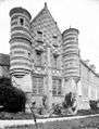
- The Chateau of Alincourt
Picture Gallery
-
Chateau of Alincourt
-

Chateau of Alincourt
-

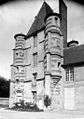
Tower of the Chateau
-
-
-

Chateau entrance
-

-

-

Chateau detail
-

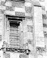
Chateau window
-
-

-

-

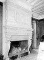
Chateau interior
-
Notable people linked to the commune
- Hilaire Flandre (1937-2004), born in Alincourt Mayor of Alincourt, Regional Councillor then Senator for Champagne-Ardenne.
See also
- Communes of the Ardennes department
- Cantons of the Ardennes department
- Arrondissements of the Ardennes department
External links
- Alincourt on the old National Geographic Institute website (French)
- Alincourt on Lion1906
- Alincourt on Google Maps
- Alincourt on Géoportail, National Geographic Institute (IGN) website (French)
- Alincourt on the 1750 Cassini Map
- Alincourt on the INSEE website (French)
- INSEE (French)
Notes and references
Notes
- ↑ At the beginning of the 21st century, the methods of identification have been modified by law No. 2002-276 of 27 February 2002 , the so-called "law of local democracy" and in particular Title V "census operations" which allow, after a transitional period running from 2004 to 2008, the annual publication of the legal population of the different French administrative districts. For municipalities with a population greater than 10,000 inhabitants, a sample survey is conducted annually, the entire territory of these municipalities is taken into account at the end of the period of five years. The first "legal population" after 1999 under this new law came into force on 1 January 2009 and was based on the census of 2006.
References
| Wikimedia Commons has media related to Alincourt. |