Albula Alps
| Albula Alps | |
|---|---|
| Albula-Alpen | |
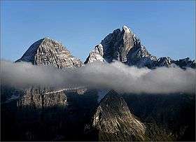
 Piz Kesch | |
| Highest point | |
| Peak | Piz Kesch |
| Elevation | 3,418 m (11,214 ft) |
| Coordinates | 46°37′N 09°52′E / 46.617°N 9.867°ECoordinates: 46°37′N 09°52′E / 46.617°N 9.867°E |
| Geography | |
 Albula Alps | |
| Country | Switzerland |
| State | Graubünden |
| Parent range | Western Rhaetian Alps |
| Borders on | Oberhalbstein Range, Silvretta Range and Bernina Range |
| Topo map | Swiss Federal Office of Topography swisstopo |
The Albula Alps are a mountain range in the Alps of eastern Switzerland. They are considered to be part of the Central Eastern Alps, more specifically the Western Rhaetian Alps.[1] They are named after the river Albula. The Albula Alps are separated from the Oberhalbstein Alps in the west by the Septimer Pass and the valley of the Sursés; from the Plessur Alps in the north-west by the Landwasser valley; from the Silvretta group in the north-east by the Flüela Pass; from the Bernina Range in the south-east by the Maloja Pass and the Inn valley (upper Engadine).
The Albula Alps are drained by the rivers Albula, Gelgia, Landwasser and Inn.
Peaks

The main peaks of the Albula Alps are:
| Peak | Elevation |
|---|---|
| Piz Kesch | 3,418 m (11,214 ft) |
| Piz Calderas | 3,397 m (11,145 ft) |
| Piz Julier/Gülgia | 3,380 m (11,090 ft) |
| Piz d'Err | 3,378 m (11,083 ft) |
| Piz Ela | 3,339 m (10,955 ft) |
| Piz Üertsch | 3,267 m (10,719 ft) |
| Piz Ot | 2,645 m (8,678 ft) |
| Piz Jenatsch | 3,250 m (10,660 ft) |
| Piz Vadret (S-Chanf) | 3,229 m (10,594 ft) |
| Piz Sarsura | 3,178 m (10,427 ft) |
| Tinzenhorn/Corn da Tinizong | 3,173 m (10,410 ft) |
| Piz Lagrev | 3,165 m (10,384 ft) |
| Piz Mitgel | 3,159 m (10,364 ft) |
| Schwarzhorn (Flüela) | 3,146 m (10,322 ft) |
| Hoch Ducan/Piz Ducan | 3,063 m (10,049 ft) |
| Piz Forun | 3,052 m (10,013 ft) |
| Piz Arpschella | 3,032 m (9,948 ft) |
| Piz Grevasalvas | 2,932 m (9,619 ft) |
| Piz Lunghin | 2,780 m (9,120 ft) |
Passes
The Albula Alps are crossed by one railway tunnel, under the Albula Pass. The main mountain passes of the Albula Alps are:
| Mountain pass | location | type | elevation (m/ft) | |
|---|---|---|---|---|
| Fuorcla Calderas | Mulegns to Bever | snow | 3130 | 10,270 |
| Fuorcla d'Eschia | Madulain to Bergün | snow | 3008 | 9869 |
| Sertig Pass | Davos to S-chanf | foot path | 2762 | 9062 |
| Tinzentor | Bergün to Savognin | foot path | 2718 | 8918 |
| Ducan Pass | Davos to Bergün | foot path | 2671 | 8763 |
| Forcella di Lunghino | Maloja to the Septimer Pass | foot path | 2635 | 8645 |
| Scaletta Pass | Davos to S-chanf | bridle path | 2619 | 8593 |
| Suvretta Pass | St. Moritz to Val Bever | bridle path | 2618 | 8590 |
| Fuorcla d'Alp Fontauna | Bergün to S-chanf | foot path | 2615 | 8580 |
| Grialetsch Pass | Davos to Susch | foot path | 2546 | 8353 |
| Flüela Pass | Davos to Susch | road | 2389 | 7838 |
| Albula Pass | Bergün to La Punt-Chamues-ch | road | 2315 | 7595 |
| Septimer Pass | Bivio to Val Bregaglia | bridle path | 2311 | 7582 |
| Julier Pass | Thusis to Silvaplana | road | 2287 | 7504 |
| Maloja Pass | St. Moritz to Chiavenna | road | 1815 | 5955 |
See also
References
- ↑ Reynolds, Kev (2005). Walking in the Alps, 2nd ed., Cicerone, Singapore, p. 275, ISBN 1-85284-261-X.
- Swisstopo maps
External links
| Wikimedia Commons has media related to Albula Alps Range. |
Mountain ranges of the Western Limestone Alps according to the AVE | ||
|---|---|---|
 | ||