List of San Francisco Municipal Railway lines
The San Francisco Municipal Railway (Muni) is the public transit system for San Francisco, California. A part of the San Francisco Municipal Transportation Agency, it served 47.35 square miles (123 km2) with an operating budget of $659.5 million in 2013.[1] Muni is the eighth-largest transit system in the United States, with 219,993,600 riders in 2012.[2]
Muni began service on December 28, 1912, when the A Geary-Park line was inaugurated, running between the Financial District and the Richmond District on the western side of the city.[3] Expansion of the system and consolidation with other transit companies eventually made Muni the city's sole public transit operator in 1952, when it acquired the bankrupt California Street Cable Railroad.[4][5] Subsequent changes and adjustments to the system gave rise to the lines in use today.
The system consists of 84 routes serving the city and some parts of Daly City and Marin County. The names of all Muni routes, except those of cable car lines, have two parts: a number or letter and a street, neighborhood, or landmark, for example, the "1 California" line.[6] The bus and trolleybus lines have number designations, the rail lines have letters, and the cable car lines are typically referred to only by name (Powell-Mason, Powell-Hyde, and California). However, Muni maps abbreviate the cable car route names to PM, PH and C,[7] and they are given route numbers 59, 60, and 61, respectively, for use in Muni internal operations.[8]
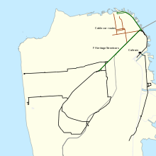
Cable car lines
| Line | Inbound terminus[a] | Outbound terminus[a] | Neighborhoods served | Links |
|---|---|---|---|---|
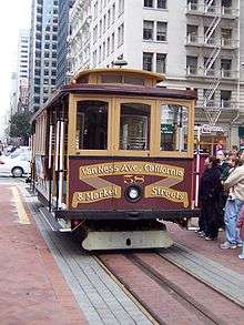
| California (C) | California and Market | California and Van Ness | Embarcadero, Financial District, Chinatown, Nob Hill | Schedule Route map (PDF) |
| Powell-Hyde (PH) | Powell and Market | Hyde and Beach | Tenderloin, Union Square, Nob Hill, Chinatown, Russian Hill, Fisherman's Wharf | Schedule Route map (PDF) |
| Powell-Mason (PM) | Powell and Market | Taylor and Bay | Tenderloin, Union Square, Nob Hill, Chinatown, North Beach, Fisherman's Wharf | Schedule Route map (PDF) |
Muni Metro and historic streetcar lines
Local bus lines
| |
Trolleybus |
| * | Weekday peak hours only |
| ♦ | Community bus (30 ft. / 9.1 meter) |
| ^ | Articulated bus (60 ft. / 18.3 meter) |
Rapid bus lines
Rapid bus lines run through six major transit corridors through the city. These lines more or less follow the corresponding local bus line, but make only a few limited stops on their routes via bus only lanes.[6]
Express bus lines
Express lines run between the outskirts of the city and downtown or between major rail stations and other points in the city.[6] These lines typically run only during peak hours, going inbound in the morning and outbound in the evening, except the 76X Marin Headlands Express, which runs on Sundays and holidays; and the 83X Mid-Market Express, which runs in both directions during peak hours. Asterisked (*) lines indicate that they run only during morning peak hours.
Owl bus lines
Owl lines provide night bus service from 1am to 5am daily (including holidays).
The 90 Owl route is a combination of the daytime 47 Van Ness and 9 San Bruno routes, while the 91 Owl route is a combination of the daytime K Ingleside, 8 Bayshore, T Third, 30 Stockton, and 28 19th Avenue routes. The 5 Fulton, 24 Divisadero, 44 O'Shaughnessy, and 48 Quintara-24th Street Owl routes are truncated from their daytime counterparts. The L and N Owl motor coaches replace daytime light rail service and run on surface streets, making local stops, rather than in the Market Street Subway, Twin Peaks Tunnel, and Sunset Tunnel.
| |
Trolleybus |
In addition to the regular nightly Owl service, Muni provides irregular bus substitutions along the K Ingleside, L Taraval, M Ocean View, N Judah, and T Third lines on weekend and holiday mornings between 5am and the opening of the Market Street Subway (7am on Saturdays, 8am on Sundays and holidays). The L and N Owl weekend morning routes differ slightly from the nightly L and N Owl routes and do not make local stops along their surface street detours, instead stopping only at stops used by the normal L and N daytime light rail routes.
See also
Notes
- a As with bus stops in general, termini range from underground stations to major landmarks to street intersections.[9]
- b The K Ingleside and T Third Street lines are essentially one single line. When entering West Portal Station from Balboa Park Station, a K train changes signs into a T and runs to Sunnydale Station. When entering Embarcadero Station from Sunnydale, a T train changes signs into a K and runs to Balboa Park.[10]
- c During peak hours, the 8AX and 8BX substitute the 8 in the peak commute direction. The 8 runs in the reverse commute.[11]
References
- ↑ "FY 2013 and FY 2014 Budget Book" (PDF). San Francisco Metropolitan Transportation Agency. July 1, 2012. p. 58. Retrieved August 15, 2013.
- ↑ "Transit Ridership Report: Fourth Quarter 2012" (PDF). American Public Transportation Association. March 1, 2013. p. 1. Retrieved August 15, 2013.
- ↑ McKane, John; Perles, Anthony (1982). Inside Muni: The Properties and Operations of the Municipal Railway of San Francisco. Glendale, CA: Interurban Press. p. 174. ISBN 978-0-916374-49-5.
- ↑ "A Brief History of the Cable Cars". Market Street Railway. Retrieved January 15, 2010.
- ↑ Matoff, Tom (June 1999). "The Muni Paradox — A Brief Social History of the Municipal Railway". Urbanist. San Francisco Planning and Urban Research Association. Retrieved January 15, 2010.
- 1 2 3 "San Francisco Travel FAQ". San Francisco Convention and Visitors Bureau. Retrieved January 15, 2010.
- ↑ San Francisco Municipal Railway Route Map (PDF) (Map). San Francisco Municipal Transportation Agency. Retrieved August 15, 2013.
- ↑ "FY11 Q3/Q4 Year-End Service Standards Scorecard – Summary" (PDF). San Francisco Municipal Transportation Agency. August 17, 2011. p. 43. Retrieved August 15, 2013.
- ↑ "How to Ride Buses". San Francisco Municipal Transportation Agency. Retrieved August 15, 2013.
- ↑ "KT-Ingleside/Third Street". San Francisco Municipal Transportation Agency. Retrieved August 15, 2013.
- ↑ "8 Bayshore". San Francisco Municipal Transportation Agency. Retrieved August 15, 2013.
External links
| Muni Metro | |
|---|---|
| Muni Metro System features | |
| Heritage streetcar services | |
| Other Muni services | |
| Projects | |
| Connecting services | |
| Agencies and organizations | |
| Museums | |
| Miscellaneous | |
Category | |