Zermatt
| Zermatt | ||
|---|---|---|
 | ||
| ||
 Zermatt | ||
|
Location of Zermatt  | ||
| Coordinates: 46°01′N 7°45′E / 46.017°N 7.750°ECoordinates: 46°01′N 7°45′E / 46.017°N 7.750°E | ||
| Country | Switzerland | |
| Canton | Valais | |
| District | Visp | |
| Government | ||
| • Mayor |
Christoph Bürgin (as of 2004) | |
| Area[1] | ||
| • Total | 242.69 km2 (93.70 sq mi) | |
| Elevation | 1,608 m (5,276 ft) | |
| Population (Dec 2015[2]) | ||
| • Total | 5,759 | |
| • Density | 24/km2 (61/sq mi) | |
| Postal code | 3920 | |
| SFOS number | 6300 | |
| Localities | Blatten, Findeln, Gornergrat, Ried, Schwarzsee, Z'mutt | |
| Surrounded by | Alagna Valsesia (IT-VC), Ayas (IT-AO), Ayer, Bionaz (IT-AO), Evolène, Gressoney-La-Trinité (IT-AO), Macugnaga (IT-VB), Randa, Saas-Almagell, Täsch, Valtournenche (IT-AO) | |
| Twin towns | Alfano (Italy) | |
| Website |
www SFSO statistics | |

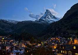
Zermatt is a municipality in the district of Visp in the German-speaking section of the canton of Valais in Switzerland. It has a population of about 5,800 inhabitants.
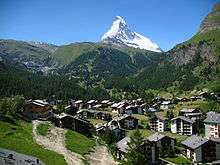
The town lies at the upper end of Mattertal at an elevation of 1,620 m (5,310 ft), at the foot of Switzerland's highest peaks. It lies about 10 km (6.2 mi) from the over 10,800 ft (3,291.84 m) high Theodul Pass bordering Italy.
Zermatt is famed as a mountaineering and ski resort of the Swiss Alps. Until the mid-19th century, it was predominantly an agricultural community; the first and tragic ascent of the Matterhorn in 1865 was followed by a rush on the mountains surrounding the village, leading to the construction of many tourist facilities. The year round population (as of December 2015) is 5,759[2], though there may be several times as many tourists in Zermatt at any one time. Much of the local economy is based on tourism, with about half of the jobs in town in hotels or restaurants[3] and just under half of all apartments are vacation apartments.[4] Just over one-third of the permanent population was born in the town, while another third moved to Zermatt from outside Switzerland.[5]
Etymology
The name of Zermatt, as well as that of the Matterhorn itself, derives from the alpine meadows, or matten (in German), in the valley. The name appeared first as Zur Matte ("at the meadow") and became later Zermatt. It does not appear until 1495 on a map or 1546 in a text, but may have been employed long before.
Praborno or Prato Borno (prato also means meadow) are the older names of Zermatt; they appear in the ancient maps as early as the thirteenth century.[6] The French-speaking people from the Aosta Valley and from the French-speaking part of canton Valais (Wallis) used this name until about 1860 in the form of Praborne, or Praborgne. The reason of this change from Praborno to Zermatt is attributed to the gradual replacement of the Romance-speaking people by German-speaking colony.[7][8]
Geography
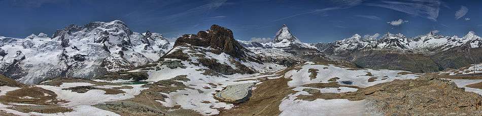
The town of Zermatt lies at the southern end of the Matter Valley (German: Mattertal), which is one of the lateral branches of the great Valley of the Rhone. Zermatt is almost completely surrounded by the high mountains of the Pennine Alps among which Monte Rosa (specifically its tallest peak, named Dufourspitze), Switzerland's highest peak at 4,634 metres (15,203 ft) above sea level. It is followed by the Dom (4,545 m [14,911 ft]), Lyskamm (4,527 m [14,852 ft]), Weisshorn (4,505 m [14,780 ft]) and the Matterhorn (4,478 m [14,692 ft]). Most of the Alpine four-thousanders are located around Zermatt or in the neighbouring valleys.


Zermatt is traversed by the main river of the valley: the Matter Vispa,[9] which rises at the glaciers at the feet of the highest peaks: the Gorner Glacier on the east side near Monte Rosa and the Zmutt Glacier on the west side between Dent d'Hérens and Dent Blanche.
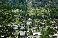
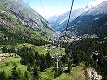
The town of Zermatt, while dense, is geographically small. There are three main streets which run along the banks of the river Matter Vispa, and numerous cross-streets, especially around the station and the church which forms the centre of Zermatt. In general anything is at most a thirty-minute walk away. There are several "suburbs" within Zermatt. Winkelmatten, which was once a separate hamlet, lies on a hill (1,670 m [5,480 ft]) on the southern side. Steinmatten is located on the eastern bank of the main river.
Many hamlets are located in the valleys above Zermatt, however they are not usually inhabited all year round. Zum See (1,766 m [5,794 ft]) lies south of Zermatt on the west bank of the Gorner gorge, near Furi where a cable car station is located (1,867 m [6,125 ft]). On the side of Zmutt valley (west of Zermatt) lies the hamlet of Zmutt (1,936 m [6,352 ft]), north of the Zmuttbach river. Findeln (2,051 m [6,729 ft]) is located in the eastern valley above the Findelbach river. It lies below the Sunnegga station (2,278 m [7,474 ft]). Located near a train station of the Gornergratbahn, Riffelalp (2,222 m [7,290 ft]) is one of the highest hamlets with a chapel.
Zermatt had an area, (as of the 2004/09 survey) of 242.69 km2 (93.70 sq mi).[1] Of this area, about 9.4% is used for agricultural purposes, while 4.6% is forested. Of the rest of the land, 0.8% is settled (buildings or roads) and 85.2% is unproductive land. Over the past two decades (1979/85-2004/09) the amount of land that is settled has increased by 54 ha (130 acres) and the agricultural land has decreased by 160 ha (400 acres).[10]
Climate
| Climate data for Zermatt (Reference period 1981–2010) | |||||||||||||
|---|---|---|---|---|---|---|---|---|---|---|---|---|---|
| Month | Jan | Feb | Mar | Apr | May | Jun | Jul | Aug | Sep | Oct | Nov | Dec | Year |
| Average high °C (°F) | 0.2 (32.4) |
1.3 (34.3) |
3.7 (38.7) |
7.3 (45.1) |
12.1 (53.8) |
15.6 (60.1) |
18.9 (66) |
17.9 (64.2) |
15.4 (59.7) |
11.2 (52.2) |
4.6 (40.3) |
1.1 (34) |
9.1 (48.4) |
| Daily mean °C (°F) | −4.8 (23.4) |
−4.0 (24.8) |
−1.5 (29.3) |
2.0 (35.6) |
6.7 (44.1) |
10.0 (50) |
12.5 (54.5) |
11.7 (53.1) |
9.0 (48.2) |
4.8 (40.6) |
−0.8 (30.6) |
−3.8 (25.2) |
3.5 (38.3) |
| Average low °C (°F) | −8.4 (16.9) |
−7.8 (18) |
−5.5 (22.1) |
−2.2 (28) |
2.1 (35.8) |
4.8 (40.6) |
6.8 (44.2) |
6.7 (44.1) |
4.2 (39.6) |
0.7 (33.3) |
−4.0 (24.8) |
−7.1 (19.2) |
−0.8 (30.6) |
| Average precipitation mm (inches) | 43 (1.69) |
46 (1.81) |
49 (1.93) |
50 (1.97) |
61 (2.4) |
56 (2.2) |
47 (1.85) |
60 (2.36) |
41 (1.61) |
55 (2.17) |
55 (2.17) |
48 (1.89) |
611 (24.06) |
| Average snowfall cm (inches) | 54.5 (21.46) |
58.7 (23.11) |
46.6 (18.35) |
37.6 (14.8) |
10.1 (3.98) |
2.2 (0.87) |
0.0 (0) |
0.0 (0) |
1.1 (0.43) |
6.2 (2.44) |
40.9 (16.1) |
66.8 (26.3) |
324.7 (127.83) |
| Average precipitation days (≥ 1.0 mm) | 6.6 | 6.3 | 7.7 | 6.7 | 10.0 | 8.6 | 8.9 | 9.9 | 6.9 | 6.7 | 7.0 | 6.7 | 92.0 |
| Average snowy days (≥ 1.0 cm) | 8.0 | 7.0 | 5.4 | 4.1 | 1.3 | 0.1 | 0.0 | 0.0 | 0.1 | 1.5 | 5.4 | 7.2 | 45.3 |
| Average relative humidity (%) | 65 | 66 | 65 | 66 | 67 | 68 | 65 | 70 | 70 | 67 | 67 | 66 | 67 |
| Mean monthly sunshine hours | 85 | 103 | 135 | 146 | 159 | 175 | 200 | 185 | 166 | 139 | 93 | 81 | 1,666 |
| Percent possible sunshine | 54 | 58 | 56 | 58 | 56 | 60 | 68 | 68 | 69 | 65 | 58 | 55 | 61 |
| Source: MeteoSwiss[11] | |||||||||||||
Tourism

The village was "discovered" by mid-nineteenth-century British mountaineers, most notably Edward Whymper, whose conquest of the Matterhorn made the village famous. The Matterhorn was one of the last alpine mountains to be conquered (in 1865), and the first expedition that reached the top ended dramatically with only 3 of the 7 climbers surviving the descent. The story is related in the Matterhorn Museum.
Zermatt is a starting point for hikes into the mountains, including the Haute Route that leads to Chamonix in France and the Patrouille des Glaciers. Cable cars and chair lifts carry skiers in the winter and hikers in the summer; the highest of them leads to the Klein Matterhorn at 3,883 m (12,740 ft), a peak on the ridge between Breithorn and Matterhorn that offers spectacular views in all directions. It is possible to cross into Italy via the Cervinia cable car station. A spectacular rack railway line (the Gornergratbahn, the highest open-air railway in Europe) runs up to the summit of the Gornergrat at 3,089 m (10,134 ft). Zermatt is also the western terminus for the Glacier Express rail service connecting to St. Moritz and the MGB (Matterhorn-Gotthard-Bahn).
Together with eleven other towns Zermatt is a member of the community Best of the Alps.[12]
Transport
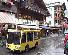
To prevent air pollution, which could obscure the town's view of the Matterhorn, the entire town is a combustion-engine car-free zone. Almost all vehicles in Zermatt are battery driven and almost completely silent. Electric vehicles are allowed for local commerces. The Cantonal police can issue a permit which allows residents to drive and park at the northern outskirts. Some emergency (fire trucks, ambulances, etc.) and municipal (garbage trucks, etc.) vehicles are also allowed to use combustion engines.
Passenger vehicles operating within Zermatt include tiny electric shuttles provided by hotels to carry visitors from the main train station (or the taxi transfer point just outside town) to the hotel properties, "electro" taxis operated by four major Zermatt families, and "electro" buses, which serve two routes: one between the major hotel areas and the stations of the various ski-lifts, and the other following a similar route but also serving the more rural "suburb" of Winkelmatten. Horse-drawn carriages can also be found; some are operated by hotels and others are available for hire.

Most visitors reach Zermatt by cog railway train from the nearby town of Täsch (Zermatt shuttle). Trains also depart for Zermatt from farther down the valley at Visp and Brig, which are on the main Swiss rail network. The town also has a heliport (ICAO: LSEZ) and a local helicopter operator, Air Zermatt, which also provides alpine rescue services.
In 2007, a project group was formed to evaluate options for development of the local transportation network (as the "electro" buses do not have enough capacity). The results of this study are published in the December 2007 edition of Zermatt Inside. The six options explored are a coaster, a funicular, a metro, moving sidewalks, a gondola and more "electro" buses.[13]
Skiing in Zermatt
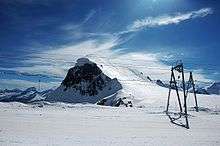
Zermatt is known throughout the world for its skiing, especially Triftji for its moguls. The high altitude results in consistent skiing continuously throughout the summer.
Skiing in Zermatt is split up into four areas: Sunnegga, Gornergrat, Klein Matterhorn and Schwarzsee. There is also a connection to Cervinia and Valtournenche in Italy through the Plateau Rosa glacier.[14][15]
In 2008, Zermatt hosted an "Infinity Downhill Race". The race took place on 13 and 14 December and comprised a course descending from the Matterhorn Glacier Paradise (3,800 m (12,500 ft)) and finished in Zermatt itself (1,600 m (5,200 ft)). The course was 20 kilometres (12 miles) long and featured a 2,200 metres (7,218 feet) descent.[16]
Sunnegga
The Sunnegga Paradise is accessed via the SunneggaExpress funicular railway, followed by a gondola to Blauherd and finally a cable car onwards to the Rothorn (3,103 m) above. The topography of the mountain and the valley tends to keep the Rothorn clear and sunny, even when Zermatt is submerged in cloud.
From Blauherd there is a gondola down to Gant, and from there a connecting cablecar goes to Hohtälli. This cable car and the newer 4-seat chairlift Sunnegga-Findeln-Breitboden provide connections between Sunnegga and Gornergrat. With few steep slopes, this mountain is often used to train younger skiers.
Gornergrat

The Gornergrat is served by the Gornergrat railway, a 29-minute ride to the Gornergrat peak (3,089 m), via Riffelalp, Rotenboden and Riffelberg, (with limited stops at Findelbach and Landtunnel just above Zermatt). At the summit, the hotel and restaurant have been refurbished and accommodate a shopping centre. Riffelalp station is linked to Riffelalp Resort by a short tramway line named Riffelalptram.[17]
A cable car heads up from Hohtälli to the Rote Nase (3,247 m). This final lift serves a freeride area but can be unreliable as this mountainside requires good snow cover to be skiable. The lifts in this area generally open for the season in late February or early March - cablecar is now permanently closed, with no replacement lift planned. A new slope leading back from Hohtälli to Kellensee just under the Gornergrat replaced this lift to maintain the link from the Rothorn to Gornergrat.
Klein Matterhorn / Schwarzsee
Near the southern end of Zermatt, the Matterhorn Express gondola transports passengers up to the interchange station at Furi. From here there is access to Schwarzsee via a gondola to the right, a cable car that leads on to the Trockener Steg midstation (and then on to the Klein Matterhorn), and a new gondola, opened on 18 December 2006, links Furi to Riffelberg on the Gornergrat mountain. This lift addresses one of the most persistent criticisms of Zermatt: that it is very difficult to ski the two sides of the valley without a tiresome trek through Zermatt between the Gornergratbahn and the Matterhorn Express at opposite ends of the town.
Testa Grigia at the top of the Theodul Pass serves as a connection to the Italian ski-resorts of Cervinia and Valtournenche. From the Swiss side it is only reachable by skilift, but from the Italian side by a chairlift and by a cablecar. There are customs offices here as well as a small alpine museum.
Zermatt is marketed as an all year skiing resort, with summer skiing limited to the Theodul Glacier behind the Klein Matterhorn. Whilst strictly true, during the off season in May and June there will only tend to be one or two runs open, and the main glacier area does not open until July.
In operation since 25 October 2003, the Furggsattel six-seater chairlift has twelve (of eighteen) masts that stand directly on the glacial ice of the Theodul Glacier - a first for Switzerland. It is one of very few lifts worldwide with bottom- and top-station in different countries, respectively Switzerland and Italy.
History of the lift system
- 1898 Start of summer operation of Gornergratbahn.
- 1928 Gornergratbahn introduces a twice daily winter sports service to Riffelalp.
- 1939 Development of Theodul area from Breuil Cervinia to Testa Grigia.
- 1942 Zermatt-Sunnegga skilift (summer: foot lift, replaced by chairlift in 1967).
- 1946 Weisti trainer skilift (moved to Riffelberg in 1969). Zermatt-Sunnegga sideways-facing chairlift (replaced by funicular in 1980).
- 1947 Sunnegga-Blauherd skilift (replaced by cable car in 1967).
- 1955 Cableway Plan Maison-Furgghorn (discontinued 1992).
- 1956 Suspension lift Gornergrat-Hohtälli (due to be discontinued in the summer of 2007). Skilift Riffelberg (replaced by chairlift 2003). Skilift Furi (discontinued 1960). Chairlift Findeln-Sunegga (due to be replaced in the summer of 2007).
- 1957 Suspension lift Zermatt-Furi.
- 1958 Suspension lift Hohtälli-Stockhorn (due to be discontinued in the summer of 2007). Furi-Schwarzsee suspension lift (replaced by cable car lift 2002).
- 1960 Skilift Garten (discontinued 2003).
- 1962 Suspension lift Furgg-Schwarzsee (replaced by group turnaround lift in 1991).
- 1963 Skilift Hornli.
- 1964 Suspension lift Furi-Furgg (replaced by Matterhorn Express in 2002). Theodullift (replaced by extension of Gandegglift 2003). Skilift Triftji-RoteNase
- 1965 Furgg-Trockener Steg suspension lift. Skilift National (replaced by chairlift Patrullarve 1989).
- 1967 Cable car lift Sunnegga-Blauherd (replaced by combi system in 2005). Suspension lift Blauherd-Rothorn (replaced in 1996). Skilift Furgsattel (replaced by chairlift in 2003). Skilift Eisfluh (replaced by chairlift 2001). Passlift (replaced by extension to Gandegglift 2003).
- 1968 Platform skilift Kumme (replaced by chairlift 1982). Skilift Gandegg (extended and renewed in 2003).
- 1971 Cablecar Gant-Blauherd. Skilift Gant-Platte (discontinued 2002). Skilift Riffelberg-Gifthittli (replaced by chairlift 2003). Skilift Test Grigia 1.
- 1979 Suspensionlift Trockener Steg-Klein Matterhorn.
- 1980 Funicular Zermatt-Sunnegga. Skilift Testa Grigia 2 (moved to Plateau Rosa 3 2005). Border skilift (Gobba di Rollin). Skilift Plateau Rosa 1.
- 1982 Suspension lift Furi-Trockener Steg. Cable car Zermatt-Furi. Chairlift Kumme-Rothorn.
- 1984 Joint skipass in Zermatt.
- 1986 Suspension lift Hohtälli-Rote Nase.
- 1989 Chairlift Patrullarve-Blauherd.
- 1991 Chairlift Furgg-Sandiger Boden-Theodul Glacier. Skilift Plateau Rosa 2. Group turnaround lift Furgg-Schwazsee.
- 1995 Joint skipass Zermatt-Cervinia.
- 1996 Suspension lift Blauherd-Rothorn.
- 1998 Suspension lift Gant-Hohtälli.
- 1999 Electronic ticketing system introduced.
- 2001 Chairlift Eisfluh-Sunnegga.
- 2002 Merger of Zermatt Bergbahnen. Cable car lifts Matterhorn Express (Zermatt-Furi-Schwarzsee).
- 2003 Chairlift Furgsattel Gletcherbahn. Chairlift Gifthittli.
- 2005 Combi system (car/chair) Sunnegga-Blauherd. Passenger lift funicular-Riedweg.
- 2006 Suspension lift Furi-Schweigmatten-Riffelberg.
- 2007 End of operations of the Gornergrat - Hohtälli tram, replaced by a red slope Hohtälli - Kellensee.
- 2007 End of operations of the Hohtälli - Stockhorn tram, replaced by a surface lift in 2008.
- 2007 Clearing of the skitunnel at Riffelberg, increasing the capacity of this slope.
- 2007 four-seat chairlift Sunnegga-Findeln-Breitboden.
Developments
The Zermatt Bergbahnen's website[18] mentions a few projects for the following years:
- 2010 Chairlift at Garten (Furgg), replacing an old surface lift.
- 2011 Cable car Testa Grigia-Klein Matterhorn.
As well as several changes to the slopes, and the placement of new snowmaking installations.
Coat of arms
The blazon of the municipal coat of arms is Gules a lion rampant Or langued of the first on Coupeaux Vert between two Mullets of Five Argent in chief.[19]
Demographics

Zermatt has a population (as of December 2015) of 5,759.[2] As of 2013, 39.0% of the population are resident foreign nationals. Over the last 3 years (2010-2013) the population has changed at a rate of 0.54%. The birth rate in the municipality, in 2013, was 9.5 while the death rate was 4.9 per thousand residents.[10]
Most of the population (as of 2000) speaks German (4,093 or 68.4%) as their first language, Portuguese is the second most common (719 or 12.0%) and Italian is the third (474 or 7.9%). There are 226 people who speak French and 1 person who speaks Romansh.[5]
As of 2008, the population was 51.6% male and 48.4% female. The population was made up of 1,840 Swiss men (31.6% of the population) and 1,166 (20.0%) non-Swiss men. There were 1,837 Swiss women (31.5%) and 985 (16.9%) non-Swiss women.[20] Of the population in the municipality, 2,214 or about 37.0% were born in Zermatt and lived there in 2000. There were 720 or 12.0% who were born in the same canton, while 774 or 12.9% were born somewhere else in Switzerland, and 2,039 or 34.1% were born outside of Switzerland.[5]
As of 2013, children and teenagers (0–19 years old) make up 18.5% of the population, while adults (20–64 years old) are 69.5% and seniors (over 64 years old) make up 12.0%.[10]
As of 2000, there were 2,763 people who were single and never married in the municipality. There were 2,830 married individuals, 207 widows or widowers and 188 individuals who are divorced.[5]
As of 2000, there were 2,441 private households in the municipality, and an average of 2.2 persons per household.[21] There were 921 households that consist of only one person and 128 households with five or more people. In 2000, a total of 2,167 apartments (52.1% of the total) were permanently occupied, while 1,890 apartments (45.4%) were seasonally occupied and 103 apartments (2.5%) were empty.[4] Of the 977 inhabited buildings in the municipality, in 2000, about 22.8% were single family homes and 45.5% were multiple family buildings. Additionally, about 10.8% of the buildings were built before 1919, while 14.4% were built between 1991 and 2000.[22] In 2012 the rate of construction of new housing units per 1000 residents was 13.65. The vacancy rate for the municipality, in 2014, was 0.28%.[10]
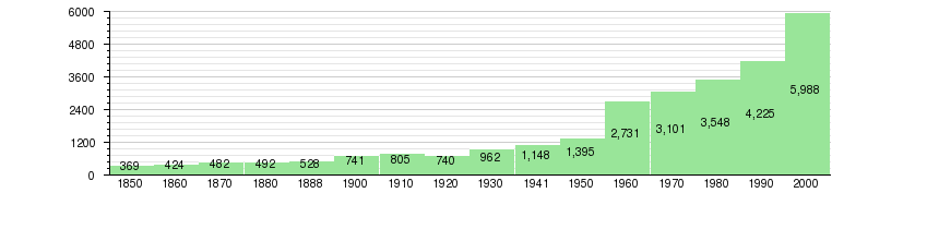
The historical population is given in the following chart:[23]
Heritage sites of national significance
The petroglyphs and prehistoric grinding stone at Hubelwäng is listed as a Swiss heritage site of national significance.[24]
Politics
In the 2011 federal election the most popular party was the CVP with 43.7% of the vote. The next three most popular parties were the SVP (33.3%), the FDP (14.1%) and the SP (4.1%). In the federal election, a total of 1378 votes were cast, and the voter turnout was 48.1%.[25]
In the 2007 federal election the most popular party was the CVP which received 68.98% of the vote. The next three most popular parties were the SVP (19.61%), the SP (6.3%) and the FDP (3.51%). In the federal election, a total of 1,326 votes were cast, and the voter turnout was 46.0%.[26]
In the 2009 Conseil d'Etat/Staatsrat election a total of 1,009 votes were cast, of which 66 or about 6.5% were invalid. The voter participation was 34.4%, which is much less than the cantonal average of 54.67%.[27] In the 2007 Swiss Council of States election a total of 1,289 votes were cast, of which 105 or about 8.1% were invalid. The voter participation was 45.4%, which is much less than the cantonal average of 59.88%.[28]
Economy
About half of the jobs in Zermatt are in the hotel and restaurant industry.
As of 2012, there were a total of 6,370 people employed in the municipality. Of these, a total of 42 people worked in 19 businesses in the primary economic sector. The secondary sector employed 521 workers in 68 separate businesses. Finally, the tertiary sector provided 5,807 jobs in 736 businesses. In 2013 a total of 13.7% of the population received social assistance.[10]
In 2008 the total number of full-time equivalent jobs was 4,261. The number of jobs in the primary sector was 20, all of which were in agriculture. The number of jobs in the secondary sector was 538 of which 83 or (15.4%) were in manufacturing and 385 (71.6%) were in construction. The number of jobs in the tertiary sector was 3,703. In the tertiary sector, 531 or 14.3% were in wholesale or retail sales or the repair of motor vehicles, 477 or 12.9% were in the movement and storage of goods, 2,178 or 58.8% were in a hotel or restaurant, 38 or 1.0% were in the information industry, 54 or 1.5% were the insurance or financial industry, 116 or 3.1% were technical professionals or scientists, 56 or 1.5% were in education and 87 or 2.3% were in health care.[3]
In 2000, there were 744 workers who commuted into the municipality and 89 workers who commuted away. The municipality is a net importer of workers, with about 8.4 workers entering the municipality for every one leaving.[29] Of the working population, 7.1% used public transportation to get to work, and 2.6% used a private car.[21]
Religion

From the 2000 census, 4,458 or 74.4% were Roman Catholic, while 458 or 7.6% belonged to the Swiss Reformed Church. Of the rest of the population, there were 131 members of an Orthodox church (or about 2.19% of the population), there were 2 individuals (or about 0.03% of the population) who belonged to the Christian Catholic Church, and there were 59 individuals (or about 0.99% of the population) who belonged to another Christian church. There were 4 individuals (or about 0.07% of the population) who were Jewish, and 82 (or about 1.37% of the population) who were Muslim. There were 6 individuals who were Buddhist and 4 individuals who belonged to another church. 205 (or about 3.42% of the population) belonged to no church, are agnostics or atheists, and 602 individuals (or about 10.05% of the population) did not answer the question.[5]
Education
In Zermatt about 1,988 or (33.2%) of the population have completed non-mandatory upper secondary education, and 470 or (7.8%) have completed additional higher education (either university or a Fachhochschule). Of the 470 who completed tertiary schooling, 51.1% were Swiss men, 21.1% were Swiss women, 14.0% were non-Swiss men and 13.8% were non-Swiss women.[5]
During the 2010-2011 school year there were a total of 677 students in the Zermatt school system. The education system in the Canton of Valais allows young children to attend one year of non-obligatory Kindergarten.[31] During that school year, there 6 kindergarten classes (KG1 or KG2) and 106 kindergarten students. The canton's school system requires students to attend six years of primary school. In Zermatt there were a total of 24 classes and 458 students in the primary school. The secondary school program consists of three lower, obligatory years of schooling (orientation classes), followed by three to five years of optional, advanced schools. There were 219 lower secondary students who attended school in Zermatt.[32] All the upper secondary students attended school in another municipality.
As of 2000, there were 98 students in Zermatt who came from another municipality, while 23 residents attended schools outside the municipality.[29]
Crime
In 2014 the crime rate, of the over 200 crimes listed in the Swiss Criminal Code (running from murder, robbery and assault to accepting bribes and election fraud), in Zermatt was 56.3 per thousand residents. This rate is only 68.7% of the cantonal rate. During the same period, the rate of drug crimes was 7 per thousand residents. This rate is about one and a half times greater than the rate in the district, but is only 68.0% of the rate in the canton and is only 70.7% of the national rate. The rate of violations of immigration, visa and work permit laws was 0.5 per thousand residents. This rate is lower than average, only 71.4% of the low rate in the district and is only 14.3% of the rate in the canton and 10.2% of the rate for the entire country.[33]
See also
References
- Swisstopo maps
- 1 2 Arealstatistik Standard - Gemeindedaten nach 4 Hauptbereichen
- 1 2 3 Swiss Federal Statistical Office - STAT-TAB, online database – Ständige und nichtständige Wohnbevölkerung nach institutionellen Gliederungen, Geburtsort und Staatsangehörigkeit (German) accessed 30 August 2016
- 1 2 Swiss Federal Statistical Office STAT-TAB Betriebszählung: Arbeitsstätten nach Gemeinde und NOGA 2008 (Abschnitte), Sektoren 1-3 Archived 25 December 2014 at the Wayback Machine. (German) accessed 28 January 2011
- 1 2 Swiss Federal Statistical Office STAT-TAB - Datenwürfel für Thema 09.2 - Gebäude und Wohnungen Archived 7 September 2014 at the Wayback Machine. (German) accessed 28 January 2011
- 1 2 3 4 5 6 STAT-TAB Datenwürfel für Thema 40.3 - 2000 Archived 9 August 2013 at the Wayback Machine. (German) accessed 2 February 2011
- ↑ W. A. B. Coolidge, " Swiss Travels and Guide Books," p. 255
- ↑ The names of Zermatt, W. A. B. Coolidge
- ↑ Rey, Guido, The Matterhorn, p. 290
- ↑ The Matter Vispa originates from the Zmuttbach, Gornera and Findelbach
- 1 2 3 4 5 Swiss Federal Statistical Office - Regional portraits Archived 5 January 2016 at the Wayback Machine. accessed 2 May 2016
- ↑ "Climate Normals Zermatt 1981–2010" (PDF). Zürich-Flughafen, Switzerland: Swiss Federal Office of Meteorology and Climatology - MeteoSwiss. 25 April 2016. Retrieved 2016-10-08.
- ↑ Zermatt member page on Best of the Alps
- ↑ "Zermatt Inside". Zermatt.
- ↑ Trail Map 2007/08
- ↑ ski-zermatt.com
- ↑ The world's biggest drop snowskiing.com
- ↑ (German) Riffealptram on Riffelalp Resort website
- ↑ "Planned Projects (Zermatt Bergbahnen)". ZBAG. Archived from the original on 2008-08-22. Retrieved 2008-02-24.
- ↑ Flags of the World.com accessed 4 October 2011
- ↑ Ständige Wohnbevolkerung nach Geschlecht und Heimat am 31.12.2009.xls (German) (French) accessed 24 August 2011
- 1 2 Swiss Federal Statistical Office Archived 5 January 2016 at the Wayback Machine. accessed 4 October 2011
- ↑ Swiss Federal Statistical Office STAT-TAB - Thema 09 - Bau- und Wohnungswesen (German) accessed 5 May 2016
- ↑ Swiss Federal Statistical Office STAT-TAB Bevölkerungsentwicklung nach Region, 1850-2000 Archived 30 September 2014 at the Wayback Machine. (German) accessed 29 January 2011
- ↑ "Kantonsliste A-Objekte". KGS Inventar (in German). Federal Office of Civil Protection. 2009. Archived from the original on 28 June 2010. Retrieved 25 April 2011.
- ↑ Swiss Federal Statistical Office - Nationalratswahlen 2011: Parteistärken, Wahlbeteiligung, fiktive Wählende Archived 14 November 2013 at the Wayback Machine. (German) accessed 2 May 2016
- ↑ Swiss Federal Statistical Office, Nationalratswahlen 2007: Stärke der Parteien und Wahlbeteiligung, nach Gemeinden/Bezirk/Canton Archived 14 May 2015 at the Wayback Machine. (German) accessed 28 May 2010
- ↑ Staatsratswahlen vom 1. März 2009 (German) accessed 24 August 2011
- ↑ Ständeratswahl 2007 (German) accessed 24 August 2011
- 1 2 Swiss Federal Statistical Office - Statweb (German) accessed 24 June 2010
- ↑ "Infobroschüre Zermatt - 2014" (pdf) (Statistics) (in German). Retrieved 3 September 2015.
- ↑ EDK/CDIP/IDES (2010). Kantonale Schulstrukturen in der Schweiz und im Fürstentum Liechtenstein / Structures Scolaires Cantonales en Suisse et Dans la Principauté du Liechtenstein (PDF) (Report). Retrieved 24 June 2010.
- ↑ Obligatorische Schulzeit (German) accessed 24 August 2011
- ↑ Statistical Atlas of Switzerland accessed 5 April 2016
External links
| Wikimedia Commons has media related to Zermatt. |
| Wikivoyage has a travel guide for Zermatt. |
| Wikisource has the text of the 1920 Encyclopedia Americana article Zermatt. |
- Zermatt.ch Official website
- Air Zermatt website (German)
- Municipality of Zermatt (German)
- Burgergemeinde Zermatt (German)
- Webcams in Zermatt
- Photo gallery (English)
- Images from Zermatt
- Live Webcam Zermatt