Gorner Glacier
| Gornergletscher | |
|---|---|
|
Gorner Glacier (left), central Monte Rosa massif with Monte Rosa Glacier, and the confluence with the Border Glacier (2006) | |
| Type | Valley glacier |
| Location | Valais, Switzerland |
| Coordinates | 45°58′11″N 7°48′6″E / 45.96972°N 7.80167°ECoordinates: 45°58′11″N 7°48′6″E / 45.96972°N 7.80167°E |
| Area | 60 km2 (23 sq mi) (1973)[1] |
| Length | 12.4 km (7.7 mi) (2014)[1] |
| Status | Retreating |
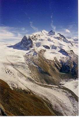
The Gorner Glacier (German: Gornergletscher) is a valley glacier found on the west side of the Monte Rosa massif close to Zermatt in the canton of Valais, Switzerland. It is about 12.4 km (7.7 mi) long (2014) and 1 to 1.5 km (0.62 to 0.93 mi) wide. The entire glacial area of the glacier related to Gorner Glacier is 57 km2 (22 sq mi) (1999), which makes it the second largest glacial system in the Alps after the Aletsch Glacier system. Numerous smaller glaciers connect with the Gorner Glacier. Its (former) tributaries are (clockwise on this map): Gornergletscher (after which the whole system is named, but the upper part is almost disconnected from the lower part nowadays), Monte Rosa Gletscher, Grenzgletscher (nowadays by far its main tributary), Zwillingsgletscher, Schwärzegletscher, Breithorngletscher, Triftjigletscher, and Unterer Theodulgletscher (although the last three ones are actually disconnected now).
The Grenzgletscher (English: Border Glacier) between the central Monte Rosa massif and the Liskamm to the south is nowadays by far the lower Gorner Glacier's main tributary. The Gorner Glacier's upper part is almost already disconnected from its lower part. Also the former tributaries Breithorngletscher, Triftjigletscher, and Unterer Theodulgletscher left their connections to the Gorner Glacier during the last century. The Lower Theodul Glacier in the 1980s.

An interesting feature of this glacier is the Gornersee, an ice marginal lake at the confluence area of the Gorner- and Grenzgletscher. This lake fills every year and drains in summer, usually as a Glacial lake outburst flood. This is one of few glacial lakes in the Alps exhibiting this kind of behaviour.
There are also several interesting surface features including crevasses and table top forms where large surface boulders have been left stranded above the glaciers surface. Supported by ice that the boulder has sheltered from melting that has effected the more exposed surrounding ice.
Due to the immense information about the glacier, it is perfect for a glacier project.
It is the source of the river Gornera which flows down through Zermatt itself. However, most of its water gets captured by a water catchment station of the Grande Dixence hydroelectric power plant. This water then ends up in the Lac des Dix, the main reservoir of Grande Dixence.
The glacier as well as the surrounding mountains can be seen from the Gornergrat (3,100 m (10,200 ft)), connected from Zermatt by a Gornergratbahn (GGB) railway line.
Retreating Glacier(s)
Like almost all other glaciers in the Alps, and most glaciers on the globe as well, due to global warming the Gorner Glacier is a retreating glacier. And in a quite dramatic way. Nowadays (2014), Gorner Glacier retreats with about 30 metres (98 ft) every year, but with a record loss of 290 metres (950 ft) in 2008. Since its last major expansion (in modern era, after last glacial period) in 1859 it lost more than 2,500 metres (8,200 ft) in distance.[2]
In these days (~2015) this becomes quite obvious since the uneducated visitor usually misidentifies Gorner Glacier's main tributary as its upper part: the Grenzgletscher (English: Border Glacier) on the south side of the central, visible Monte Rosa massif. However, the upper Gorner Glacier traditionally is to be found on the north side. The reason is that the upper part of the Gorner Glacier is currently losing contact with its lower part and now the Grenzgletscher has become its much larger tributary. So it is easy to mismatch the Border Glacier as the upper Gorner Glacier.
But this was not the case in earlier times, as the following comparison impressively shows (be also aware of the retreating of the Monte Rosa Glacier in the middle, the one in between Gorner and Border Glaciers):
 Around 1890–1900 (photomechanical print): The upper Gorner Glacier (left) obviously still is the main tributary of the lower part; the old Monte Rosa Hut (built 1894-95) would have been found just few metres above/next to the north-eastern border of the Grenzgletscher (in the middle; compare with the third picture)
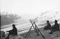 1914–1918: Swiss Army patrol during World War I overlooking the confluence of the Gorner and Border Glaciers; even the Monte Rosa Glacier in the middle still has contact to the Gorner Glacier
 2005: The connection between the upper and lower part is still given and the moraine is still clearly fed by its upper part; the old Monte Rosa Hut (2,795 m) is easily recognizable above the left over, north-eastern lateral moraine of the Border Glacier (in the middle, right)
 2007: The loss of thickness (about 200 m (660 ft)) of the lower Gorner Glacier since its major expansion in 1859 is easily recognizable on the south flank of the Gornergrat by the left over and much higher situated lateral moraine (see the light-coloured part above the grey flank; as seen from Klein Matterhorn)
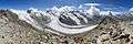 2012: The upper Gorner Glacier is losing contact to its lower part; especially the middle moraine will stop being fed by its originally upper part
See also
| Wikimedia Commons has media related to Gorner Glacier. |
References
- 1 2 "Gornergletscher, Zermatt (VS)". Swiss Glacier Monitoring, VAW/ETHZ & EKK/SCNAT. 2014. Retrieved 2016-03-18.
- ↑ "Glacier length variations of the year 2008". Swiss Glacier Monitoring, VAW/ETHZ & EKK/SCNAT. 2014. Retrieved 2016-03-18.
External links
- Gorner Glacier glaciology.ethz.ch
- Gorner Glacier swisseduc.ch