Zekharia
| Zekharia | |
|---|---|
 | |
 Zekharia | |
| Coordinates: 31°42′35.28″N 34°56′42.35″E / 31.7098000°N 34.9450972°ECoordinates: 31°42′35.28″N 34°56′42.35″E / 31.7098000°N 34.9450972°E | |
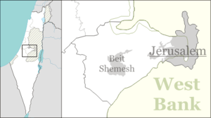
| District | Jerusalem |
| Council | Mateh Yehuda |
| Affiliation | Moshavim Movement |
| Founded | 1950 |
| Founded by | Kurdish Jews |
| Population (2015)[1] | 1,039 |
Zekharia (Hebrew: זְכַרְיָה) is a moshav in central Israel. Located near Beit Shemesh, it falls under the jurisdiction of Mateh Yehuda Regional Council. In 2015 it had a population of 1,039.
Geographical location
The village lies next to the road between Bayt Jibrin and the Jerusalem-Jaffa highway, and has a mean elevation of 268 meters above sea level. It is bordered on its south-east by the Elah Valley, and is situated about 5 kilometres (3.1 mi) south-west of Beit Shemesh. The mountain of Azekah can be seen directly to the south of the village. The villagers obtained their drinking water from two communal wells:- al-Saflani well which was drilled next to Wadi 'Ajjur, and al-Sarara well located north of the village.[2]
History
The town called Beth Zacharia is said to have existed in Roman times.[3] According to legend, the body of the prophet Zachariah was found here in 415 CE and a church and monastery were established.[4] The village was under the administrative jurisdiction of Bayt Jibrin. During the Mamluk era, the village was a dependency of Hebron, and formed part of the waqf supporting the Ibrahimi Mosque.[5]
In the 1480s C.E. Felix Fabri described how he stayed in a "roomy inn", next to a "fair mosque" in the village.[6]
Ottoman era
In 1517, Az-Zakariyya was incorporated into the Ottoman Empire with the rest of Palestine, and in 1596 the village appeared in the Ottoman tax registers listed as Zakariyya al-Battikh under the administration of the nahiya ("subdistrict") of Quds (Jerusalem), part of the Sanjak of Quds. It had a population of 47 Muslim households and paid taxes on wheat, barley, olives, beehives, and goats.[7]
A makam (shrine) in the village dedicated to the prophet Zechariah was noticed by Edward Robinson in 1838.[8] A Dutch traveler to Palestine in the 19th century records its name as Kefr Zakaria.[9]
In 1863 the French explorer Victor Guérin found the place to have five hundred inhabitants,[10] while in 1883, the Palestine Exploration Fund's Survey of Western Palestine described Zakariyya as sitting on a slope above a broad valley surrounded by olive groves.[11]
British Mandate era
In the 1922 census of Palestine conducted by the British Mandate authorities, Zakariyya (Zekharia) had a population of 683, all Muslim,[12] increasing in the 1931 census to 742, still all Muslims, in 189 occupied houses.[13] In 1944/45 a total of 6,523 dunums of village land was allocated to cereals, while 961 dunums were irrigated or used for orchards, of which 440 dunums were planted with olive trees.[14][15]
State of Israel
In the 1948 Arab–Israeli War, Az-Zakariyya was the longest lasting Arab community in the southern Jerusalem Corridor.[16] The village was defended by the Egyptian Muslim Brotherhood, the Arab Liberation Army and local militiamen, who were defeated by the Israel Defense Forces on 23 October 1948. In the course of Operation Yoav, the 54th Battalion of the Givati Brigade, found the village "almost empty", as most of the residents had fled to the nearby hills. As late as March 1949, however, there were still about one-hundred and forty-five Arab residents remaining in the village. On March 19, 1950 the transfer of the Arabs of Zakariyya (Zekharia), at the request of Interior Ministry, was approved and the order was carried out on June 9, 1950.[17]
The manner of expulsion of the villagers is not mentioned.[18] Some of the villagers moved to Ramla and Lod, while others ("perhaps the majority") settled in the Dheisheh Refugee Camp in the West Bank.[17]
In 1950 moshav Zekharia was established by Kurdish Jewish immigrants on the village site.[18] During the 1960s, most of the older buildings in the village were destroyed to make room for the new.[19]
In 1992, Walid Khalidi described the remaining structures: "The mosque and a number of houses, some occupied by Jewish residents and others deserted, remain on the site. Large sections of the site itself are covered with wild vegetation. The mosque is in a state of neglect and an Israeli flag is planted on top of the minaret. [..] One of the occupied houses is a two-storey stone structure with a flat roof. Its second story windows have round arches and grillwork. Parts of the surrounding lands are cultivated by Israeli farmers."[18]
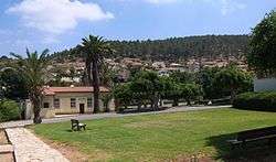
Today, Zekharia is a vibrant Jewish village, with its own convenient store and petrol station, playgrounds and park, with public buildings of worship and entertainment.
Culture
The village was formerly known for its Palestinian costumes. A wedding dress from Zakariyya (ca. 1930) is part of the collection in Museum of International Folk Art (MOIFA) at Museum of New Mexico at Santa Fe.[20]
Gallery
 Residence in Moshav Zakariah
 Residential houses in Moshav Zakariah
 Remains of a minaret and mosque from an earlier period
 Az-Zakariyya, pre-1926[21]
 Main synagogue in Zakariah
 General view as seen looking toward the southeast and the Elah Valley
 Residential area built on adjacent hilltop
 House in Zakariah
 Meandering road in Zakariah
 Green lawn at a public park in Zakariah
 Convenient store in Zakariah
 Sign post at entrance of Moshav
 Highway passing by Zakariah
References
- ↑ "List of localities, in Alphabetical order" (PDF). Israel Central Bureau of Statistics. Retrieved 16 October 2016.
- ↑ Khalidi, pp224–225
- ↑ Josephus, Antiquities (Book xii, chapter ix, verse 4)
- ↑ Petersen, 2001, p. 320
- ↑ Mujir al-Din, 1876, pp. 230-1. Cited and translated in Petersen, 2001, p. 320
- ↑ Fabri, 1893, p.427
- ↑ Hütteroth and Abdulfattah, 1977, p. 120
- ↑ Robinson and Smith, 1841, vol 2, pp. 343, 344
- ↑ van de Velde, 1858, p.115
- ↑ Guérin, 1869, p. 371
- ↑ Conder and Kitchener, 1883, SWP III, p. 27. Quoted in Khalidi, 1992, 225
- ↑ Barron, 1923, Table V, Sub-district of Hebron, p. 10
- ↑ Mills, 1932, p. 34
- ↑ Government of Palestine, Department of Statistics. Village Statistics, April, 1945. Quoted in Hadawi, 1970, p. 94
- ↑ Khalidi, 1992, p. 225
- ↑ Morris, 2004, p. 521
- 1 2 Mordechai Bar-On, officer in charge of the eviction. Quoted in Morris, 2004, p. 521
- 1 2 3 Khalidi, 1992, p. 226
- ↑ Arnon Shai (2006). "The Fate of Abandoned Arab Villages in Israel, 1965-1969". History and Memory. 18 (2): 86–106.
- ↑ Stillman, 1979, p. 60.
- ↑ Khalidi, p206