Mesilat Zion
| Mesilat Zion | |
|---|---|
 | |
 Mesilat Zion | |
| Coordinates: 31°48′6.48″N 35°0′41.39″E / 31.8018000°N 35.0114972°ECoordinates: 31°48′6.48″N 35°0′41.39″E / 31.8018000°N 35.0114972°E | |
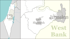
| District | Jerusalem |
| Council | Mateh Yehuda |
| Affiliation | Moshavim Movement |
| Founded | 1950 |
| Founded by | Yemenite Jews |
| Population (2015)[1] | 1,263 |
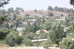
Mesilat Zion (Hebrew: מְסִלַּת צִיּוֹן, מסילת ציון, lit. Track of Zion) is a moshav in central Israel. Located near Beit Shemesh with an area of 1,000 dunams, it falls under the jurisdiction of Mateh Yehuda Regional Council. In 2015 it had a population of 1,263.
History
The moshav was established on the land of the depopulated Palestinian village of Bayt Mahsir in 1950.[2]
The moshav was established as a work village in 1950 by immigrants from Yemen. After a few years the founders left and were replaced by Cochin Jews. The name of the village is symbolic, as it is located near the Burma Road. It symbolizes the breaking of the siege over Jerusalem during the 1948 Arab–Israeli War, it is based on verses from the Book of Isaiah, chapter 62, "For Zion's sake will I not hold my peace, and for Jerusalem's sake I will not rest....Go through, go through the gates; prepare ye the way of the people; cast up, cast up the highway; gather out the stones; lift up a standard for the people....Say ye to the daughter of Zion, Behold, thy salvation comes."[3]
References
- ↑ "List of localities, in Alphabetical order" (PDF). Israel Central Bureau of Statistics. Retrieved 16 October 2016.
- ↑ Khalidi, Walid (1992), All That Remains: The Palestinian Villages Occupied and Depopulated by Israel in 1948, Washington D.C.: Institute for Palestine Studies, p. 277, ISBN 0-88728-224-5
- ↑ Isaiah 62:1-11