Wisconsin Highway 28
| ||||
|---|---|---|---|---|
 | ||||
| Route information | ||||
| Maintained by WisDOT | ||||
| Length: | 59.8 mi[1] (96.2 km) | |||
| Major junctions | ||||
| West end: |
| |||
|
| ||||
| East end: |
| |||
| Location | ||||
| Counties: | Dodge, Washington, Sheboygan | |||
| Highway system | ||||
| ||||

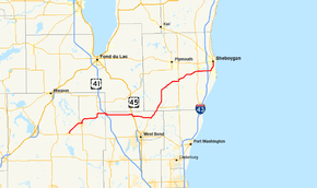
State Trunk Highway 28 (often called Highway 28, STH 28 or WIS 28) is a state highway in the U.S. state of Wisconsin. It runs east–west in southeastern Wisconsin between Horicon and Sheboygan. The route is 59.77 miles (96.19 km) long and is generally two-lane road beyond portions of the road within the city of Sheboygan and the half-mile portion of the highway near Waldo which is concurrent with STH 57.
Route description
WIS 28 begins at a junction with WIS 33 in Horicon. The highway junctions with WIS 67 northeast of Horicon in Mayvillle and follows WIS 67 north into Theresa. The two highways turn north onto WIS 175 there. WIS 28 turns east off the concurrency one mile further north and junctions with Interstate 41 after another two miles (3 km) east. The Washington County line is at this junction.[2] WIS 28 crosses US 45 in Kewaskum and turns northeast onto WIS 144 north in Boltonville.[3]
WIS 144 turns east off WIS 28 one mile (1.6 km) north of the Sheboygan County line and WIS 28 continues north, passing through Batavia before turning northeast at its junction with Sheboygan County Trunk Highway S. The highway passes through Cascade and joins for a half-mile north with WIS 57 in Waldo. WIS 28 turns east, then leaves its former alignment for a straight-line road south of Sheboygan Falls which was built in the mid-1980s.[4] The road then runs through the southernmost reaches of the Kohler Company's landholdings, and defines the southern boundary of the Blackwolf Run golf course, along with the Deer Trace shopping center before its intersection with Interstate 43. Reaching Sheboygan city limits, the road is defined as Washington Avenue, running one mile into the city before a northward turn onto South Business Drive, the former US 141, which eventually merges within the city's original plat with 14th Street. The highway's eastern terminus shares the intersection of Erie Avenue and North 14th Street with WIS 23's eastern terminus and WIS 42's southern terminus just north of the Sheboygan River.[5]

History
In 1918, the original routing of WIS 28 was between Dubuque and Spring Green along the present day US 23 and the WIS 23 alignments (prior to the construction of the expressway between Dubuque and Dodgeville).[6] The highway was extended a couple years later to end in Reedsburg, and then expanded to Sheboygan along the former routing of WIS 26 in 1924.[7] Formerly through eastern Sheboygan County, the road's alignment took it through Sheboygan Falls, Kohler, and Sheboygan via what is known as the Lower Falls Road and within Sheboygan, Indiana Avenue.
Major intersections
| County | Location | mi | km | Destinations | Notes |
|---|---|---|---|---|---|
| Dodge | Horicon | ||||
| Mayville | WIS 28 East follow WIS 67 North | ||||
| Theresa | WIS 175 North follow WIS 67 North / WIS 28 East | ||||
| WIS 28 West / WIS 175 South follow WIS 67 South | |||||
| Washington | Kewaskum | ||||
| Boltonville | WIS 144 North follow WIS 28 East | ||||
| Sheboygan | | WIS 144 South follow WIS 28 West | |||
| | |||||
| Cascade | |||||
| Waldo | |||||
| Sheboygan Falls | |||||
| Sheboygan | |||||
| Former U.S. 141 | |||||
| 1.000 mi = 1.609 km; 1.000 km = 0.621 mi | |||||
References
- ↑ Bessert, Chris. "Wisconsin Highways: Highways 20-29 (Highway 28)". Wisconsin Highways. Retrieved 2007-03-20.
- ↑ Dodge Co (pdf) (Map). Wisconsin Department of Transportation. Retrieved 2008-02-24.
- ↑ Washington Co (pdf) (Map). Wisconsin Department of Transportation. Retrieved 2008-02-24.
- ↑ Shebyogan Co (pdf) (Map). Wisconsin Department of Transportation. Retrieved 2008-02-24.
- ↑ Google (2008-02-24). "Shebyogan, WI, United States of America" (Map). Google Maps. Google. Retrieved 2008-02-24.
- ↑ "Original State Trunk Highway System in Wisconsin". Southeast Wisconsin Regional Planning Commission. 1918. Retrieved 2008-02-24.
- ↑ Bessert, Chris. "Wisconsin Highways: Highways 20-29 (Highway 28)". Wisconsin Highways. Retrieved 2008-02-24.
| Wikimedia Commons has media related to Wisconsin Highway 28. |