Wintersburg, Arizona
| Wintersburg, Arizona | |
|---|---|
| Census-designated place | |
 Location in Maricopa County and the state of Arizona | |
 Wintersburg, Arizona Location in the United States | |
| Coordinates: 33°25′28″N 112°52′05″W / 33.42444°N 112.86806°WCoordinates: 33°25′28″N 112°52′05″W / 33.42444°N 112.86806°W | |
| Country | United States |
| State | Arizona |
| County | Maricopa |
| Elevation | 1,008 ft (307 m) |
| Population (2010) | |
| • Total | 136 |
| Time zone | Mountain (MST) (UTC-7) |
| ZIP codes | 85354 |
Wintersburg is a census-designated place in Maricopa County, Arizona, United States, located about 50 miles west of Phoenix, and 15 miles west of Buckeye along Interstate 10.
Wintersburg is home to the Palo Verde Nuclear Generating Station, the largest nuclear power plant in the United States.
Demographics
As of the census[1] of 2010, there were 136 people residing in the CDP. The population density was 274.5 people per square mile. The racial makeup of the CDP was 82.35% White, 2.21% Black or African American, 1.47% Native American, 2.21% Pacific Islander, and 11.76% from other races. 26.47% of the population were Hispanic or Latino of any race.
References
- ↑ http://factfinder2.census.gov/faces/tableservices/jsf/pages/productview.xhtml?pid=DEC_10_PL_GCTPL2.ST13&prodType=table
Municipalities and communities of Maricopa County, Arizona, United States | ||
|---|---|---|
| Cities | 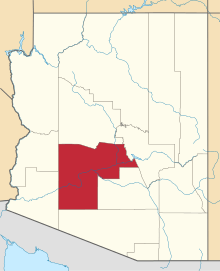 | |
| Towns | ||
| CDPs | ||
| Unincorporated communities |
| |
| Indian reservations | ||
| Ghost towns | ||
| Footnotes | ‡This populated place also has portions in an adjacent county or counties | |
This article is issued from Wikipedia - version of the 6/7/2015. The text is available under the Creative Commons Attribution/Share Alike but additional terms may apply for the media files.