William Howell House, Storm Cellar
|
Storm Cellar, William Howell House | |
 | |
  | |
| Location | Co. Rd. 47 E of jct. with AR 305, Clay, Arkansas |
|---|---|
| Coordinates | 35°23′47″N 91°47′6″W / 35.39639°N 91.78500°WCoordinates: 35°23′47″N 91°47′6″W / 35.39639°N 91.78500°W |
| Area | less than one acre |
| Architectural style | Rough-hewn fieldstone masonry |
| MPS | White County MPS |
| NRHP Reference # | 91001295[1] |
| Added to NRHP | July 20, 1992 |
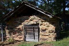
The William Howell House Storm Cellar is a historic rural farm outbuilding in northern White County, Arkansas. It is located off County Road 47, east of its junction with Arkansas Highway 305, near the crossroads village of Clay. It is a low masonry structure, built of mortared local fieldstone and capped by a gable roof. It has a wooden door on one side, and no windows. It is estimated to have been built about 1930. Although its shape is more consistent with that of other buildings used for food storage, it is referred to locally as a storm cellar. It is the best-preserved of this type of building in White County.[2]
The building was listed on the National Register of Historic Places in 1992.[1]
See also
References
- 1 2 National Park Service (2010-07-09). "National Register Information System". National Register of Historic Places. National Park Service.
- ↑ "NRHP nomination for William Howell House, Storm Cellar" (PDF). Arkansas Preservation. Retrieved 2016-01-27.
| Topics | |
|---|---|
| Lists by states |
|
| Lists by insular areas | |
| Lists by associated states | |
| Other areas | |
| |
This article is issued from Wikipedia - version of the 12/2/2016. The text is available under the Creative Commons Attribution/Share Alike but additional terms may apply for the media files.