Wien-Umgebung District
| Bezirk Wien-Umgebung | |
|---|---|
| District | |
 | |
| Country | Austria |
| State | Lower Austria |
| Number of municipalities | 21 |
| Area | |
| • Total | 484.5 km2 (187.1 sq mi) |
| Population (1 January 2016) | |
| • Total | 120,446 |
| • Density | 250/km2 (640/sq mi) |
| Time zone | CET (UTC+1) |
| • Summer (DST) | CEST (UTC+2) |
| NUTS code | AT126, AT127 |

Bezirk Wien-Umgebung is a district of the state of Lower Austria in Austria. The district comprises four non-contiguous districts on the outer fringes of Vienna: these are Klosterneuburg and Gerasdorf to the north of the city, Schwechat to its south-east and Purkersdorf on Vienna's western side.
Vienna International Airport, the headquarters of Austrian Airlines, and the headquarters of Niki are in the city of Schwechat, in the district.[1][2][3]
The district will exist as such until the end of 2016. In 2017 the municipalities in this district will become part of four adjacent districts.[4][5]
Municipalities
Suburbs, hamlets and other subdivisions of a municipality are indicated by white dots.
- Ebergassing
- Ebergassing, Wienerherberg
- Fischamend
- Fischamend-Dorf, Fischamend-Markt
- Gablitz
- Gerasdorf bei Wien
- Gerasdorf, Föhrenhain, Kapellerfeld, Oberlisse, Seyring
- Gramatneusiedl
- Himberg
- Himberg, Velm, Pellendorf, Gutenhof
- Klein-Neusiedl
- Klosterneuburg
- Höflein an der Donau, Kierling, Klosterneuburg, Kritzendorf, Maria Gugging, Weidling, Weidlingbach
- Lanzendorf
- Leopoldsdorf
- Maria Lanzendorf
- Mauerbach
- Hainbuch, Mauerbach, Steinbach
- Moosbrunn
- Pressbaum
- Au am Kraking, Pfalzau, Pressbaum, Rekawinkel
- Purkersdorf
- Rauchenwarth
- Schwadorf
- Schwechat
- Kledering, Mannswörth, Rannersdorf, Schwechat
- Tullnerbach
- Irenental, Tullnerbach-Lawies, Untertullnerbach
- Wolfsgraben
- Zwölfaxing
Situation in 2017
The district Wien-Umgebung will be dissolved in 2017. 13 municipalities in the South East will become part of the Bruck an der Leitha District, namely Ebergassing, Fischamend, Gramatneusiedl, Himberg, Klein-Neusiedl, Lanzendorf, Leopoldsdorf, Maria Lanzendorf, Moosbrunn, Rauchenwarth, Schwadorf Schwechat and Zwölfaxing. Six municipalities in the West will become part of the Sankt Pölten-Land District, namely Gablitz, Mauerbach, Pressbaum, Purkersdorf, Tullnerbach and Wolfsgraben. Klosterneuburg in the North West will become part of the Tulln District and Gerasdorf bei Wien in the North East will become part of the Korneuburg District.[4][5]

References
- ↑ "Offices in Austria." Austrian Airlines. Retrieved on 26 May 2009.
- ↑ "About Us Contact." Niki. Retrieved on 2 September 2009.
- ↑ "Information about the city plan." City of Schwechat. Retrieved on 5 September 2009.
- 1 2 "Wien-Umgebung will be dissolved" (in German). Niederösterreichische Nachrichten (NÖN.at). 9 October 2015.
- 1 2 "Wien-Umgebung: Aufteilung geändert" [Wien-Umgebung: Modified division] (in German). Niederösterreichische Nachrichten (NÖN.at). 24 September 2015.
| Cities | 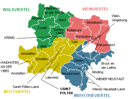 | |
|---|---|---|
| Districts | ||
Coordinates: 48°18′N 16°19′E / 48.300°N 16.317°E