Whitecliffs Branch
| Whitecliffs Branch | |||||||||||||||||||||||||||||||||||||||||||||||||||||||||
|---|---|---|---|---|---|---|---|---|---|---|---|---|---|---|---|---|---|---|---|---|---|---|---|---|---|---|---|---|---|---|---|---|---|---|---|---|---|---|---|---|---|---|---|---|---|---|---|---|---|---|---|---|---|---|---|---|---|
| Overview | |||||||||||||||||||||||||||||||||||||||||||||||||||||||||
| Type | Heavy Rail | ||||||||||||||||||||||||||||||||||||||||||||||||||||||||
| System | New Zealand Government Railways (NZGR) | ||||||||||||||||||||||||||||||||||||||||||||||||||||||||
| Status | Closed | ||||||||||||||||||||||||||||||||||||||||||||||||||||||||
| Locale | Canterbury, New Zealand | ||||||||||||||||||||||||||||||||||||||||||||||||||||||||
| Termini |
Darfield Junction Whitecliffs | ||||||||||||||||||||||||||||||||||||||||||||||||||||||||
| Stations | 7 | ||||||||||||||||||||||||||||||||||||||||||||||||||||||||
| Operation | |||||||||||||||||||||||||||||||||||||||||||||||||||||||||
| Opened | 3 November 1875 | ||||||||||||||||||||||||||||||||||||||||||||||||||||||||
| Closed | 31 March 1962 | ||||||||||||||||||||||||||||||||||||||||||||||||||||||||
| Owner | Railways Department | ||||||||||||||||||||||||||||||||||||||||||||||||||||||||
| Operator(s) | Railways Department | ||||||||||||||||||||||||||||||||||||||||||||||||||||||||
| Character | Rural | ||||||||||||||||||||||||||||||||||||||||||||||||||||||||
| Technical | |||||||||||||||||||||||||||||||||||||||||||||||||||||||||
| Line length | 18.4 kilometres (11.4 mi) | ||||||||||||||||||||||||||||||||||||||||||||||||||||||||
| Number of tracks | Single | ||||||||||||||||||||||||||||||||||||||||||||||||||||||||
| Track gauge | 3 ft 6 in (1,067 mm) | ||||||||||||||||||||||||||||||||||||||||||||||||||||||||
| |||||||||||||||||||||||||||||||||||||||||||||||||||||||||
The Whitecliffs Branch was a branch line railway that formed part of New Zealand's national rail network in the Canterbury region of the South Island. It was more industrial than the many rural branches on the South Island's east coast whose traffic primarily derived from agriculture, and it operated from 1875 until 1962.
Construction
What would have been the first portion of a branch line to Whitecliffs has now become part of the Midland Line. The original plan was for a straight line running directly from Rolleston to Sheffield and Springfield, with a branch built from Kirwee to Darfield. When the railway reached Kirwee, the line to Darfield was built first, and it was from here that construction of two lines began. One line was built towards Sheffield and Springfield, and one towards Whitecliffs. At that stage, it was not known which, if either, would be incorporated in the line to the West Coast.
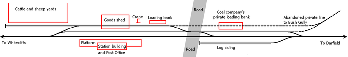
Surveys for the line from Darfield to Whitecliffs were undertaken in 1872, and with contracts let the next year, work was well under way by 1874. The line was opened all the way to Whitecliffs on 3 November 1875. Stations were established in (from junction to terminus): Hawkins, Homebush, Coalgate, Glentunnel, South Malvern, and Whitecliffs, with goods sheds located at three of these stations. Trains on the line had to deal with steep ascents between Hawkins and Homebush and on the run up to Whitecliffs.
Three proposals existed in the 19th century regarding the extension of the line. An early proposal suggested that the Whitecliffs Branch should be extended from Whitecliffs to the West Coast via the Wilberforce River and Browning's Pass. Another proposal called for a line departing the branch at Homebush and running via Lake Lyndon up to Cass, from where it would have followed roughly the same route as the present-day line via Arthur's Pass. A third proposal received the support of an 1880 Royal Commission on New Zealand's railways, calling for an extension of the branch into the Rakaia Gorge and to the coalfields near the Acheron River. None of these proposals ever came to fruition. Another significant proposal, the Canterbury Interior Main Line, would have had its junction with the Whitecliffs Branch in Homebush.
Stations
The following stations were located on the Whitecliffs Branch, in order from the junction at Darfield to the terminus:
- Hawkins
- Homebush
- Coalgate
- Glentunnel
- South Malvern
- Whitecliffs
Operation
The predominant traffic on the line was lignite coal from the mines served by the line, with two private lines running to industries from the branch, one in Homebush and one in Coalgate. It was this traffic that sustained the line's existence, but it did not eventuate in the quantities imagined as the Cantabrian coal fields proved to be small. Passenger traffic was largely handled by New Zealand Railways Department buses by the 1930s, though passenger services - primarily picnic trains - operated sporadically until 13 March 1949. Freight trains were running thrice weekly in 1951, but losses had been mounting for two decades and the coal field was close to being exhausted. Further declines in the volume of traffic on the line led to its closure on 31 March 1962.
The branch today
Some relics from the Whitecliffs Branch still exist, despite the fact that remnants of closed railways tend to disappear over time due to human and natural influences. The formation is visible in places, a bridge still stands between Hawkins and Coalgate, and some bridge abutments and piles remain in situ. Platform edges survive in Homebush, Glentunnel and Coalgate, and in Whitecliffs, the engine shed is preserved and still possesses its water tank that served steam locomotives, and a loading bank can be found nearby.
References
- Churchman, Geoffrey B., and Hurst, Tony; The Railways Of New Zealand: A Journey Through History, HarperCollins Publishers (New Zealand), 1991 reprint
- Leitch, David, and Scott, Brian; Exploring New Zealand's Ghost Railways, Grantham House, 1998 revised edition
Further reading
- Hermann, Bruce J; South Island Branch Lines p 11 (1997, New Zealand Railway & Locomotive Society, Wellington) ISBN 0-908573-70-7
External links
Coordinates: 43°29′03″S 172°00′34″E / 43.4843°S 172.0095°E