West Scrafton

Coordinates: 54°14′54″N 1°53′20″W / 54.24832°N 1.88894°W
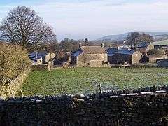
West Scrafton is a village and civil parish in Coverdale in the Yorkshire Dales, England. It is located 4 miles (6.4 km) south west of Leyburn. It falls within the Richmondshire district of North Yorkshire. The population was estimated at 70 in 2013.[1]
The village lies on the south bank of the River Cover. The parish extends 2.5 miles (4.0 km) south of the village, rising over West Scrafton Moor to the peak of Great Haw.
West Scrafton has featured several times in the British television series All Creatures Great and Small, in the episodes "A New Chapter" and "Alarms & Excursions".
Scrafton was mentioned in the Domesday Book.[2] The name is Old English, from scræf and tūn, meaning "settlement at the hollow".[3] By 1286 Scrafton had been divided into East Scrafton and West Scrafton.[2] East Scrafton was the smaller place, and is now a hamlet in the neighbouring civil parish of Caldbergh with East Scrafton.
In the Middle Ages West Scrafton was a vill held by the Abbot of Coverham. It was historically a township in the large ancient parish of Coverham in the North Riding of Yorkshire,[2] and became a separate civil parish in 1866.[4] In 1974 it was transferred to the new county of North Yorkshire.
In the 19th century a small coal mine, the West Scrafton Colliery, was worked on the moorland 1.5 miles (2.4 km) south of the village. It was abandoned in 1914.[5]
References
- ↑ "Population Estimates". North Yorkshire County Council. 2013. Retrieved 9 April 2016. In the 2011 Census the population of the parish was included with the parish of West Witton, and not separately counted.
- 1 2 3 William Page, ed. (1914). "Parishes: Coverham". Victoria County History. A History of the County of York North Riding: Volume 1. pp. 214–225. Retrieved 9 April 2016.
- ↑ Watts, Victor, ed. (2010). "Scrafton". The Cambridge Dictionary of English Place-Names. Cambridge University Press. ISBN 978 0 521 16855 7.
- ↑ "Vision of Britain website". Retrieved 9 April 2016.
- ↑ "West Scrafton Colliery". Northern Mine Research Society. Retrieved 9 April 2016.
External links
![]() Media related to West Scrafton at Wikimedia Commons
Media related to West Scrafton at Wikimedia Commons