East Scrafton

Coordinates: 54°15′28″N 1°51′56″W / 54.257735°N 1.865500°W
East Scrafton is a hamlet in the Yorkshire Dales in the Richmondshire district of North Yorkshire, England.[1][2] It is about 3 miles (5 km) south-west of Leyburn. There is also a larger West Scrafton to the south.
The name Scrafton comes from Old English and means farmstead near a hollow.[3]
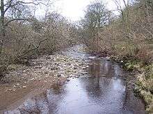
Looking down the River Cover from St Simon's Bridge, next to the ruined chapel of ease of St Simon and St Jude, by East Scrafton
References
- ↑ Ordnance Survey: Landranger map sheet 99 Northallerton & Ripon (Pateley Bridge & Leyburn) (Map). Ordnance Survey. 2013. ISBN 9780319231593.
- ↑ "Ordnance Survey: 1:50,000 Scale Gazetteer" (csv (download)). www.ordnancesurvey.co.uk. Ordnance Survey. 1 January 2016. Retrieved 18 February 2016.
- ↑ Mills, A.D. (2011) [first published 1991]. A Dictionary of British Place Names (First edition revised 2011 ed.). Oxford: Oxford University Press. p. 409. ISBN 9780199609086.
External links
![]() Media related to East Scrafton at Wikimedia Commons
Media related to East Scrafton at Wikimedia Commons
This article is issued from Wikipedia - version of the 2/20/2016. The text is available under the Creative Commons Attribution/Share Alike but additional terms may apply for the media files.