Warren Township, Clinton County, Indiana
| Warren Township | |
|---|---|
| Township | |
|
Snowy countryside in flat Warren Township | |
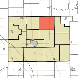 Location of Warren Township in Clinton County | |
| Coordinates: 40°23′42″N 86°25′08″W / 40.39500°N 86.41889°WCoordinates: 40°23′42″N 86°25′08″W / 40.39500°N 86.41889°W | |
| Country | United States |
| State | Indiana |
| County | Clinton |
| Organized | 1834 |
| Government | |
| • Type | Indiana township |
| Area | |
| • Total | 29.44 sq mi (76.2 km2) |
| • Land | 29.44 sq mi (76.2 km2) |
| • Water | 0 sq mi (0 km2) |
| Elevation[1] | 860 ft (262 m) |
| Population (2010) | |
| • Total | 619 |
| • Density | 21/sq mi (8/km2) |
| FIPS code | 18-80090[2] |
| GNIS feature ID | 453974 |

Warren Township is one of fourteen townships in Clinton County, Indiana. As of the 2010 census, its population was 619 and it contained 244 housing units.[3]
History
Originally part of Jackson Township, Warren was made a separate township in 1834. The first settler in the area was A. F. Whiteman who located on Section 23 in 1830.[4]
The John Young House was listed on the National Register of Historic Places in 1994.[5]
Geography
According to the 2010 census, the township has a total area of 29.44 square miles (76.2 km2), all land.[3]
Unincorporated towns
Adjacent townships
- Burlington Township, Carroll County (north)
- Monroe Township, Howard County (northeast)
- Forest Township (east)
- Michigan Township (south)
- Owen Township (west)
- Democrat Township, Carroll County (northwest)
Major highways
Cemeteries
The township contains six cemeteries: Campbell, Grays, Old Liberty, Old Prophet, Sims and Veneman.
References
- ↑ "US Board on Geographic Names". United States Geological Survey. 2007-10-25. Retrieved 2008-01-31.
- ↑ "American FactFinder". United States Census Bureau. Retrieved 2008-01-31.
- 1 2 "Population, Housing Units, Area, and Density: 2010 - County -- County Subdivision and Place -- 2010 Census Summary File 1". United States Census. Retrieved 2013-05-10.
- ↑ Claybaugh, Joseph (1913). "Warren Township". History of Clinton County, Indiana. Indianapolis: A. W. Bowen & Company.
- ↑ National Park Service (2009-03-13). "National Register Information System". National Register of Historic Places. National Park Service.
External links
Municipalities and communities of Clinton County, Indiana, United States | ||
|---|---|---|
| City | ||
| Towns | ||
| Townships | ||
| Unincorporated communities |
| |
This article is issued from Wikipedia - version of the 9/5/2015. The text is available under the Creative Commons Attribution/Share Alike but additional terms may apply for the media files.