Viola, Minnesota
| Viola, Minnesota | |
|---|---|
| Unincorporated community | |
 Viola, Minnesota  Viola, Minnesota Location of the community of Viola | |
| Coordinates: 44°03′48″N 92°16′06″W / 44.06333°N 92.26833°WCoordinates: 44°03′48″N 92°16′06″W / 44.06333°N 92.26833°W | |
| Country | United States |
| State | Minnesota |
| County | Olmsted |
| Township | Viola Township |
| Elevation | 1,155 ft (352 m) |
| Time zone | Central (CST) (UTC-6) |
| • Summer (DST) | CDT (UTC-5) |
| ZIP code | 55934 |
| Area code(s) | 507 |
| GNIS feature ID | 653671[1] |
Viola is an unincorporated community in Viola Township, Olmsted County, Minnesota, United States. It is the site of a yearly Gopher Count festival, which began in 1874.
The community is located along Olmsted County Road 2 (Viola Road) near 105th Avenue NE and Center Street. State Highway 42 (MN 42) and Olmsted County Road 24 are also in the immediate area. Nearby places include Eyota, Elgin, and Rochester.
The North Fork of the Whitewater River flows through the community.
History
Viola was platted in 1878.[2] The community was named for Viola Buck, the wife of a settler.[3]
References
- ↑ "Viola, Minnesota". Geographic Names Information System. United States Geological Survey.
- ↑ Upham, Warren (1920). Minnesota Geographic Names: Their Origin and Historic Significance. Minnesota Historical Society. p. 388.
- ↑ Chicago and North Western Railway Company (1908). A History of the Origin of the Place Names Connected with the Chicago & North Western and Chicago, St. Paul, Minneapolis & Omaha Railways. p. 134.
External links
Municipalities and communities of Olmsted County, Minnesota, United States | ||
|---|---|---|
| Cities | 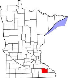 | |
| Townships | ||
| Unincorporated communities | ||
| Footnotes | ‡This populated place also has portions in an adjacent county or counties | |
This article is issued from Wikipedia - version of the 10/26/2016. The text is available under the Creative Commons Attribution/Share Alike but additional terms may apply for the media files.