Vestamager
The districts of Copenhagen municipality:
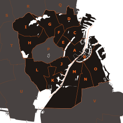
A: Indre By ("Copenhagen Center")
B: Christianshavn
C: Indre Østerbro ("Inner Østerbro")
D: Ydre Østerbro ("Outer Østerbro")
E: Indre Nørrebro ("Inner Nørrebro")
F: Ydre Nørrebro ("Outer Nørrebro")
G: Bispebjerg
H: Vanløse
I: Brønshøj-Husum
J: Vesterbro
K: Kongens Enghave
L: Valby
M: Vestamager
N: Sundbyvester
O: Sundbyøster
Vestamager most often refers to Kalvebod Fælled, but is also the name of one of the 15 administrative, statistical, and tax city districts (bydele) comprising the municipality of Copenhagen, Denmark. It lies on the south border of the municipality on the island of Amager. It covers an area of 13.99 km², has a population of 7,799 and a population density of 558 per km², making it both the largest district in area and the least densely populated district in Copenhagen.
Neighboring city districts are as follows:
- to the east is Sundbyvester
- to the north is Christianshavn, separated from Sundbyvester by Stadsgraven
- to the south is the part of Kalvebod Fælled that lies in Tårnby municipality
See also
External links
Coordinates: 55°39′00″N 12°34′30″E / 55.65000°N 12.57500°E
This article is issued from Wikipedia - version of the 9/6/2016. The text is available under the Creative Commons Attribution/Share Alike but additional terms may apply for the media files.