Vermont Route 44A
| ||||
|---|---|---|---|---|
| Back Mountain Road | ||||
|
Map of Windsor County in eastern Vermont with VT 44A highlighted in red | ||||
| Route information | ||||
| Auxiliary route of VT 44 | ||||
| Maintained by VTrans | ||||
| Length: | 2.994 mi[1] (4.818 km) | |||
| Major junctions | ||||
| South end: |
| |||
| North end: |
| |||
| Location | ||||
| Counties: | Windsor | |||
| Highway system | ||||
| ||||


Vermont Route 44A is a state highway in Windsor County, Vermont, United States. It is a spur route of VT 44 that veers south to serve the town of Weathersfield. The southern terminus of the route is at U.S. Route 5 and VT 12 in Weathersfield. Its northern terminus is at VT 44 in Windsor.
Route description
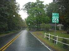
First reassurance marker on VT 44A northbound
VT 44A begins at an intersection with U.S. Route 5 and VT 12 on the west bank of the Connecticut River in the town of Weathersfield. It heads north into the town of Windsor, then turns northwest, passing over Interstate 91 and entering Ascutney State Park. It cuts across the northeastern corner of the park on its way to its northern terminus at VT 44 east of Brownsville.
Major intersections
The entire route is in Windsor County. [1]
| Location[1] | mi[1] | km | Destinations | Notes | |
|---|---|---|---|---|---|
| Weathersfield | 0.000 | 0.000 | |||
| Windsor | 2.994 | 4.818 | |||
| 1.000 mi = 1.609 km; 1.000 km = 0.621 mi | |||||
References
- 1 2 3 4 Traffic Research Unit (May 2013). "2012 (Route Log) AADTs for State Highways" (PDF). Policy, Planning and Intermodal Development Division, Vermont Agency of Transportation. Retrieved March 12, 2015.
External links
This article is issued from Wikipedia - version of the 5/21/2015. The text is available under the Creative Commons Attribution/Share Alike but additional terms may apply for the media files.