Upham Parish, New Brunswick
| Upham | |
|---|---|
| Parish | |
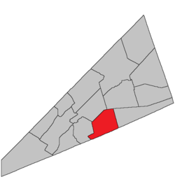 Location within Kings County, New Brunswick. | |
| Coordinates: 45°50′N 64°35′W / 45.84°N 64.59°W | |
| Country |
|
| Province |
|
| County | Kings County |
| Established | 1835 |
| Area[1] | |
| • Land | 188.55 km2 (72.80 sq mi) |
| Population (2011)[1] | |
| • Total | 1,306 |
| • Density | 6.9/km2 (18/sq mi) |
| • Pop 2006-2011 |
|
| • Dwellings | 563 |
| Time zone | AST (UTC-4) |
| • Summer (DST) | ADT (UTC-3) |
Upham is a Canadian parish in Kings County, New Brunswick.
History
Upham Parish was established in 1835: named for Joshua Upham (1741-1808), a Loyalist officer in the King's American Dragoons, a Harvard law graduate, and a judge of the New Brunswick supreme court in 1784: included Hammond Parish until 1858.
Delineation
Upham Parish is defined in the Territorial Division Act[2] as being bounded:
- North by Norton and Sussex Parishes; east by a line commencing at the southeast corner of lot number one, granted to Samuel DeForest, near Cassidy Lake, and running a north and south course from thence; south by the County line, and westerly by a line starting from a point on the County line, where the westerly side line of a three hundred acre lot, granted to Thomas Smith, or its prolongation, meets the said County line, and running northwesterly along the side line of said lot to its most westerly corner; thence a course easterly to the northeasterly angle of a three hundred acre lot granted to Richard E. Armstrong, and thence easterly in a direct line to the northeasterly angle of lot number two, granted to Robert Godfrey; thence northerly by a direct line to the southeasterly angle of lot number six, granted to William Scoullar; thence following the easterly side line of said Scoullar grant to its northeasterly corner on the Hammond River; thence following or crossing the said Hammond River to the southeasterly corner of a five hundred acre lot, granted to Charles Robertson; thence along the easterly side line of said Robertson grant to its northeasterly corner; and thence in a direct line to the northeasterly corner of a two hundred acre lot granted to James Beyea, where is standing a maple tree, and continuing the same course beyond the said maple tree to the Old Westmorland Road.[lower-alpha 1]
Governance
The entire parish forms the local service district of the parish of Upham, established in 1967 to assess for fire protection. Recreational and sports facilities were added in 2005. First aid and ambulance services (1976–2005) were formerly included.
Communities
Parish population total does not include incorporated municipalities (in bold):
|
|
|
Bodies of water & Islands
This is a list of rivers, lakes, streams, creeks, marshes and Islands that are at least partially in this parish
Demographics
PopulationPopulation trend[4]
|
LanguageMother tongue language (2006)[5]
|
Access Routes
Highways and numbered routes that run through the parish, including external routes that start or finish at the parish limits:[6]
|
|
|
See also
Footnotes
References
- 1 2 2011 Statistics Canada Census Profile: Upham Parish, New Brunswick
- ↑ "Territorial Division Act (R.S.N.B. 1973, c. T-3)". Government of New Brunswick website. Retrieved 30 August 2016.
- ↑ "No. 447" (PDF). 2015 Designated Highway Maps. Government of New Brunswick. Retrieved 30 August 2016.
- ↑ Statistics Canada: 2001, 2006 census
- ↑ Profile: Upham Parish, New Brunswick
- ↑ Atlantic Canada Back Road Atlas ISBN 978-1-55368-618-7
 |
Norton Parish | Sussex Parish | | |
| Hampton Parish | |
Hammond Parish | ||
| ||||
| | ||||
| Simonds Parish | Saint Martins Parish |
| Subdivisions | |
|---|---|
| Cities | |
| Counties | |
| |
Coordinates: 45°30′47″N 65°39′30″W / 45.513144°N 65.658331°W