University Hills, Los Angeles
| University Hills | |
|---|---|
| Neighborhood of Los Angeles | |
|
University Hills sign at Lansdowne Avenue near Eastern | |
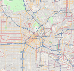 University Hills Location within Central Los Angeles | |
| Coordinates: 34°04′00″N 118°10′04″W / 34.066667°N 118.167778°W | |
| Country | United States |
| State | California |
| County | Los Angeles |
| City | Los Angeles |
| Time zone | PST (UTC-8) |
| • Summer (DST) | PDT (UTC-7) |

University Hills is a district on the East Side of Los Angeles, California. It is the site of California State University, Los Angeles.
Geography and transportation
University Hills is bordered by El Sereno on the north and west, City Terrace on the south, Alhambra on the north-east, and Monterey Park on the south-east.
Major thoroughfares include Eastern Avenue, Marianna Avenue, and Valley Boulevard. The San Bernardino and Pasadena freeways run along the district's southern and western edges, respectively.
The campus of California State University, Los Angeles occupies nearly 200 acres (0.8 km²) on a hilltop site that affords views of the San Gabriel Mountains to the north, the San Gabriel Valley to the east, metropolitan Los Angeles to the west, and the Palos Verdes Peninsula and Catalina Island to the south.
History
University Hills is in the eastern San Rafael Hills. They were part of the Pre-columbian homeland of the Tongva Indians for thousands of years, and they named this area Otsunga (place of roses).
It is the former site of one of California's 36 original adobes, built in 1776 by Franciscan missionaries, and destroyed by a fire in 1908. The area was part of the 1831 Mexican land grant of Rancho Rosa Castilla, given to Juan Ballesteros by Alta California Governor Manuel Victoria. It was named for the abundant amount of native Wood roses (Rosa californica) along the creek. [1]
In 1852, after statehood, the title passed to Jean-Baptiste Batz and his wife, Catalina. He was a Basque immigrant rancher from northern Spain. In 1882, after both died, the land was divided among six of their children. [2][3]
Recent history
For most of its history, University Hills was a neighborhood within El Sereno, which was developed more than a century ago with the expansion of the Pacific Electric Railway Red Car lines. [4] In the latter 20th century it grew differently from El Sereno and other Eastside communities in residential qualities and socioeconomic conditions. In response, the local homeowners association lobbied for renaming the community in the 1990s. In 2004 it was designated University Hills.[5] The increase in Southern California real estate values in the early 2000s attracted professionals looking for alternative neighborhoods to more distant suburbs and the Westside.[6]
The mid-2010s recovery from the 2009 Great Recession and its subsequent depressed real estate values has returned University Hills to a desirable community for new homeowners. Gentrification is changing the historically predominant Latino enclave.
The Los Angeles Derby Dolls, formerly based at "The Doll Factory" on Temple Street in Historic Filipinotown, relocated in 2015 to "The Dollosseum" on Alhambra Avenue near Valley Boulevard in El Sereno, near University Hills and CSULA. [7][8][9]
Education
Universities
University Hills is zoned to schools in the Los Angeles USD :
- City Terrace Elementary School
- El Sereno Middle School
- Wilson High School
In addition, many neighborhood residents send their kids to nearby Catholic schools .
References
- ↑ J. N. Bowman, The Rose of Castile, Western Folklore, Vol. 6, No. 3 (Jul., 1947), pp. 204–210, Western States Folklore Society
- ↑ John R. Chávez, 1998, Eastside Landmark:A History of the East Los Angeles Community Union, 1968-1993, ISBN 978-0-8047-3333-5, Stanford University Press
- ↑ Sustainable Cities and Industrial Ecology in El Sereno
- ↑ The Eastsider.com: "El Sereno historic district comes up for review"
- ↑
- ↑ Jennifer Delson, "A Campus Enclave That's a Study in Contrasts," Los Angeles Times, April 24, 2005
- ↑ Facebook.com: The Dollosseum - Home of Los Angeles Derby Dolls
- ↑ The Eastsider.com: "http://www.theeastsiderla.com/2015/03/l-a-derby-dolls-get-ready-to-roll-to-a-new-home-in-el-sereno/", 16 March 2015.
- ↑ LA Curbed.com: "Here's the Warehouse That'll Become the LA Derby Dolls Home", 17 March 2015.
- "City of Los Angeles. Public Works Committee Report: Designating the Residential Areas Surrounding California State University Los Angeles as University Hills" (13 Oct 2004)
- Los Angeles Times, Real Estate section, Neighborly Advice column: "[University Hills:] A campus enclave that's a study in contrasts" (24 April 2005)
External links
| Topics |  | |
|---|---|---|
| Government | ||
| Districts and neighborhoods |  | |
|---|---|---|
| Points of interest | ||
| Neighboring cities and communities | ||
Coordinates: 34°04′00″N 118°10′04″W / 34.06667°N 118.16778°W