Uhrichsville, Ohio
| Uhrichsville, Ohio | |
|---|---|
| City | |
|
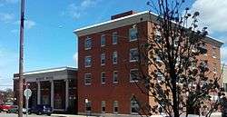
Third Street downtown | |
| Nickname(s): Twin Cities (see also Dennison, Ohio), Clay Capital of the World | |
 Location of Uhrichsville, Ohio | |
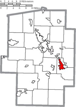 Location of Uhrichsville in Tuscarawas County | |
| Coordinates: 40°23′43″N 81°20′57″W / 40.39528°N 81.34917°WCoordinates: 40°23′43″N 81°20′57″W / 40.39528°N 81.34917°W | |
| Country | United States |
| State | Ohio |
| County | Tuscarawas |
| Township | Mill |
| Government | |
| • Mayor | Rick Dorland |
| Area[1] | |
| • Total | 2.81 sq mi (7.28 km2) |
| • Land | 2.81 sq mi (7.28 km2) |
| • Water | 0 sq mi (0 km2) |
| Elevation[2] | 856 ft (261 m) |
| Population (2010)[3] | |
| • Total | 5,413 |
| • Estimate (2012[4]) | 5,394 |
| • Density | 1,926.3/sq mi (743.7/km2) |
| Time zone | Eastern (EST) (UTC-5) |
| • Summer (DST) | EDT (UTC-4) |
| ZIP code | 44683 |
| Area code(s) | 740 |
| FIPS code | 39-78176[5] |
| GNIS feature ID | 1061719[2] |
Uhrichsville is a city in Tuscarawas County, Ohio, United States. The population was 5,413 at the 2010 census. Claymont City School District is the major education provider for the city of Uhrichsville and for the village of Dennison, Ohio. The Twin cities is a nickname used to describe Uhrichsville and Dennison because they are adjacent and similar.
Uhrichsville was originally named Waterford but called "Uhrich's Mill" after a mill owned by founder Michael Uhrich. The previous statement is on a sign entering Uhrichsville.
Uhrichsville Water Park opened in June 2008. It is heated and features slides, waterfalls, buckets, and a water jungle-gym.[6]
Geography
Uhrichsville is located at 40°23′43″N 81°20′57″W / 40.39528°N 81.34917°W (40.395208, -81.349226).[7]
The area surrounding Uhrichsville is moderately flat. According to the United States Census Bureau, the city has a total area of 2.81 square miles (7.28 km2), all land.[1]
History
Laid out under the name of Waterford in 1833, it was renamed Uhrichsville in 1839 after Michael Uhrich, a local mill operator. It benefitted from the Ohio and Erie Canal and later from the Pan Handle Railroad.[8] Railroad shops built at nearby Dennison later added further to Uhrichsville's growth.[9]
Demographics
| Historical population | |||
|---|---|---|---|
| Census | Pop. | %± | |
| 1850 | 576 | — | |
| 1860 | 646 | 12.2% | |
| 1870 | 1,541 | 138.5% | |
| 1880 | 2,790 | 81.1% | |
| 1890 | 3,842 | 37.7% | |
| 1900 | 4,582 | 19.3% | |
| 1910 | 4,751 | 3.7% | |
| 1920 | 6,428 | 35.3% | |
| 1930 | 6,437 | 0.1% | |
| 1940 | 6,435 | 0.0% | |
| 1950 | 6,614 | 2.8% | |
| 1960 | 6,201 | −6.2% | |
| 1970 | 5,731 | −7.6% | |
| 1980 | 6,130 | 7.0% | |
| 1990 | 5,604 | −8.6% | |
| 2000 | 5,662 | 1.0% | |
| 2010 | 5,413 | −4.4% | |
| Est. 2015 | 5,404 | [10] | −0.2% |
| Sources:[11][12][13][14][15][16][5][17] | |||
2010 census
As of the census[3] of 2010, there were 5,413 people, 2,176 households, and 1,379 families residing in the city. The population density was 1,926.3 inhabitants per square mile (743.7/km2). There were 2,426 housing units at an average density of 863.3 per square mile (333.3/km2). The racial makeup of the city was 96.3% White, 1.4% African American, 0.1% Native American, 0.3% Asian, 0.3% from other races, and 1.6% from two or more races. Hispanic or Latino of any race were 0.8% of the population.
There were 2,176 households of which 34.3% had children under the age of 18 living with them, 40.9% were married couples living together, 17.7% had a female householder with no husband present, 4.8% had a male householder with no wife present, and 36.6% were non-families. 30.6% of all households were made up of individuals and 14.6% had someone living alone who was 65 years of age or older. The average household size was 2.44 and the average family size was 3.04.
The median age in the city was 36.5 years. 26.7% of residents were under the age of 18; 9.2% were between the ages of 18 and 24; 24.3% were from 25 to 44; 24.5% were from 45 to 64; and 15.3% were 65 years of age or older. The gender makeup of the city was 47.3% male and 52.7% female.
2000 census
As of the census[5] of 2000, there were 5,662 people, 2,254 households, and 1,498 families residing in the city. The population density was 1,980.9 people per square mile (764.4/km²). There were 2,523 housing units at an average density of 882.7 per square mile (340.6/km²). The racial makeup of the city was 97.58% White, 1.11% African American, 0.19% Native American, 0.12% Asian, 0.09% from other races, and 0.90% from two or more races. Hispanic or Latino of any race were 0.62% of the population.
There were 2,254 households out of which 34.2% had children under the age of 18 living with them, 47.8% were married couples living together, 14.4% had a female householder with no husband present, and 33.5% were non-families. 29.7% of all households were made up of individuals and 15.8% had someone living alone who was 65 years of age or older. The average household size was 2.51 and the average family size was 3.08.
In the city the population was spread out with 28.4% under the age of 18, 8.3% from 18 to 24, 28.8% from 25 to 44, 19.1% from 45 to 64, and 15.5% who were 65 years of age or older. The median age was 35 years. For every 100 females there were 91.2 males. For every 100 females age 18 and over, there were 84.9 males.
The median income for a household in the city was $28,617, and the median income for a family was $32,217. Males had a median income of $28,138 versus $17,132 for females. The per capita income for the city was $13,144. About 12.0% of families and 14.6% of the population were below the poverty line, including 17.9% of those under age 18 and 11.0% of those age 65 or over.
Notable people
- Dean Sensanbaugher, American football player
- Cody Garbrandt, UFC Bantamweight Fighter
References
- 1 2 "US Gazetteer files 2010". United States Census Bureau. Retrieved 2013-01-06.
- 1 2 "US Board on Geographic Names". United States Geological Survey. 2007-10-25. Retrieved 2008-01-31.
- 1 2 "American FactFinder". United States Census Bureau. Retrieved 2013-01-06.
- ↑ "Population Estimates". United States Census Bureau. Retrieved 2013-06-17.
- 1 2 3 "American FactFinder". United States Census Bureau. Retrieved 2008-01-31.
- ↑ http://cityofuhrichsville.org/waterpark
- ↑ "US Gazetteer files: 2010, 2000, and 1990". United States Census Bureau. 2011-02-12. Retrieved 2011-04-23.
- ↑ Mangus, Michael; Herman, Jennifer L. (2008). Ohio Encyclopedia. North American Book Dist LLC. p. 557. ISBN 978-1-878592-68-2.
- ↑ http://freepages.genealogy.rootsweb.ancestry.com/~barbarar/history.htm J. M. Richardson, A Brief History of Tuscarora County
- ↑ "Annual Estimates of the Resident Population for Incorporated Places: April 1, 2010 to July 1, 2015". Retrieved July 2, 2016.
- ↑ "Population of Civil Divisions Less than Counties" (PDF). Statistics of the Population of the United States at the Tenth Census. U.S. Census Bureau. Retrieved 28 November 2013.
- ↑ "Population of Civil Divisions Less than Counties" (PDF). Statistics of the Population of the United States at the Tenth Census. U.S. Census Bureau. Retrieved 28 November 2013.
- ↑ "Population: Ohio" (PDF). 1910 U.S. Census. U.S. Census Bureau. Retrieved 28 November 2013.
- ↑ "Population: Ohio" (PDF). 1930 US Census. U.S. Census Bureau. Retrieved 28 November 2013.
- ↑ "Number of Inhabitants: Ohio" (PDF). 18th Census of the United States. U.S. Census Bureau. Retrieved 22 November 2013.
- ↑ "Ohio: Population and Housing Unit Counts" (PDF). U.S. Census Bureau. Retrieved 22 November 2013.
- ↑ "Incorporated Places and Minor Civil Divisions Datasets: Subcounty Population Estimates: April 1, 2010 to July 1, 2012". U.S. Census Bureau. Retrieved 25 November 2013.
Municipalities and communities of Tuscarawas County, Ohio, United States | ||
|---|---|---|
| Cities | 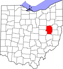 | |
| Villages | ||
| Townships | ||
| CDPs | ||
| Unincorporated communities | ||
| Ghost town | ||
| Footnotes | ‡This populated place also has portions in an adjacent county or counties | |