U.S. Route 6N
| ||||
|---|---|---|---|---|
 | ||||
| Route information | ||||
| Maintained by PennDOT | ||||
| Length: | 27.84 mi[1] (44.80 km) | |||
| Existed: | 1935 (present alignment) – present | |||
| Major junctions | ||||
| West end: |
| |||
|
| ||||
| East end: |
| |||
| Location | ||||
| Counties: | Erie | |||
| Highway system | ||||
| ||||

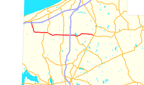
U.S. Route 6N (US 6N) is a 28-mile-long (45 km) auxiliary route of U.S. Route 6 located in Erie County, Pennsylvania. The western terminus is at U.S. Route 20 in West Springfield a half-mile north of Interstate 90 exit 3. Its eastern terminus is at U.S. Route 6 and U.S. Route 19 west of Mill Village.
Route description
US 6N begins at an intersection with US 20 in Springfield Township, heading southeast on a four-lane divided highway. The road heads through wooded areas and reaches an interchange with I-90. From here, US 6N continues south, narrowing to a two-lane undivided road and crossing under the Bessemer and Lake Erie Railroad before running through forested areas with some fields and homes. The road crosses the Conneaut Creek into Conneaut Township and passes through Cherry Hill, continuing south through a mix of farmland and woodland with a few residences. The route curves southeast and intersects PA 226, at which point it turns east. US 6N passes through more rural areas as it comes to a junction with the southern terminus of PA 215. The road continues east into Albion, where it becomes West State Street and passes homes. The route intersects PA 18, at which point that route turns east for a concurrency with US 6N on East State Street, passing through the commercial downtown and crossing the Bessemer and Lake Erie Railroad. The road passes through more residential areas, briefly crossing back into Conneaut Township before coming into Elk Creek Township and becoming an unnamed road that runs through rural areas. PA 18 splits from US 6N in Wellsburg by heading to the north, and US 6N continues east through areas of farms and woods with some homes. In the community of Lavery, the route crosses PA 98.[2][3]
Farther east, the road crosses into Washington Township and comes to an interchange with I-79, at which point the road is a four-lane divided highway that runs near businesses. Past this interchange, US 6N becomes a two-lane undivided road again passes through more rural surroundings before heading into more residential areas and entering Edinboro. Here, the name of the road becomes West Plum Street and it turns southeast past more homes. The route turns east into the commercial downtown, gaining a center left-turn lane, and intersects PA 99. Past this junction, the road name becomes East Plum Street and it becomes a two-lane road that passes more businesses. US 6N turns east-northeast onto Waterford Street and runs through more residential areas with Edinboro University of Pennsylvania to the south. The route continues back into Washington Township and curves northeast through agricultural areas with some residential and commercial development. The road heads east and passes through more farmland with occasional woods and homes. The route crosses into LeBoeuf Township and runs through more forested areas with some fields and residences. US 6N turns southeast and comes to an intersection with US 6 and US 19, where the route ends and the road continues east as part of US 6.[2][3]
History
From 1931 to 1935, US 6N occupied a different alignment through Erie County, occupying present-day Pennsylvania Route 97 from Pennsylvania Route 8 in downtown Erie to PA 8 in Union City. In an overlapping period starting earlier, from 1928 to 1933, another US 6N followed what is now US 209 between Kingston and Port Jervis, New York.[4]
Major intersections
The entire route is in Erie County.
| Location | mi[1] | km | Destinations | Notes | |
|---|---|---|---|---|---|
| Springfield Township | 0.00 | 0.00 | |||
| Exit 3 (I-90) | |||||
| Conneaut Township | |||||
| Albion | West end of PA 18 overlap | ||||
| Elk Creek Township | East end of PA 18 overlap | ||||
| Washington Township | Exit 166 (I-79) | ||||
| Edinboro | |||||
| LeBoeuf Township | 27.84 | 44.80 | |||
| 1.000 mi = 1.609 km; 1.000 km = 0.621 mi | |||||
See also
 U.S. Roads portal
 Pennsylvania portal
References
- 1 2 National Highway Planning Network (Map). 1 : 183747. Cartography by QGIS. Federal Highway Administration. 2005. Retrieved 2007-07-06.
- 1 2 Google (June 4, 2011). "overview of U.S. Route 6N" (Map). Google Maps. Google. Retrieved June 4, 2011.
- 1 2 Erie County, Pennsylvania Highway Map (PDF) (Map). PennDOT. 2011. Retrieved June 4, 2011.
- ↑ Richard F. Weingroff, U.S. 6: The Grand Army of the Republic Highway
External links
| |||