Typhoon Halola
| Typhoon (JMA scale) | |
|---|---|
| Category 2 (Saffir–Simpson scale) | |
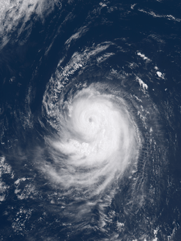 Typhoon Halola at peak intensity on July 22, 2015 | |
| Formed | July 10, 2015 |
| Dissipated | July 26, 2015 |
| Highest winds |
10-minute sustained: 150 km/h (90 mph) 1-minute sustained: 155 km/h (100 mph) |
| Lowest pressure | 955 hPa (mbar); 28.2 inHg |
| Fatalities | None |
| Damage | $1.2 million (2015 USD) |
| Areas affected | Wake Island, Japan, South Korea |
| Part of the 2015 Pacific hurricane season and 2015 Pacific typhoon season | |
Typhoon Halola, known in the Philippines as Typhoon Goring, was a small but long-lived tropical cyclone in July 2015 that traversed the Pacific Ocean along a 7,640 km (4,750 mi) long path.[1] Developing as the fifth named storm of the annual hurricane season south-southwest of Hawaii on July 11, Halola crossed the International Dateline late on July 12 and was recognized as the twelfth named storm of the annual typhoon season. It became a typhoon two days later. However, the system gradually decayed due to unfavorable conditions and weakened into a tropical depression on July 18. Halola strengthened into a tropical storm again on July 20 and became a typhoon again on the next day. It formed a short-lived eye, and it received the name Goring from the PAGASA on July 23. Halola weakened into a severe tropical storm over the Ryukyu Islands on July 25 and made landfall over Kyushu on the next day, shortly before dissipating in the Tsushima Strait.
The typhoon initially posed a significant threat to Wake Island, prompting the evacuation of all personnel; however, no damage resulted from its passage. Heavy rains and strong winds buffeted the Ryukyu Islands, with record rainfall observed in Tokunoshima. Damage was relatively limited, though the sugarcane crop sustained ¥154 million (US$1.2 million) in damage. One person was injured in Kyushu.
Meteorological history
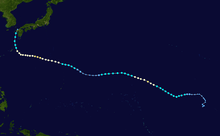
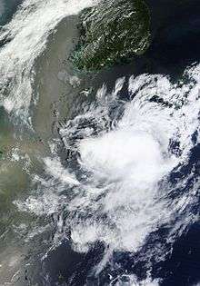
Late on July 6, a tropical disturbance formed about 1,840 km (1,145 mi) southwest of Honolulu, Hawaii.[2] During July 10, the CPHC reported that atmospheric convection around the disturbance had persisted for long enough for the system to be considered a tropical cyclone.[3] As a result, they initiated advisories on Tropical Depression One-C and estimated that the system had 1-minute sustained wind speeds of 30 mph (50 km/h).[3] Over the next day the system gradually intensified and organised further as it moved westwards, before it was named Halola by the CPHC during July 11, after it had intensified into a tropical storm.[4] The system continued to move westwards and slowly intensify over the next couple of days and moved out of the Central Pacific basin and into the Western Pacific as it crossed the International Dateline on July 12.[5][6] Within its first advisory on the system the Japan Meteorological Agency (JMA) reported that the system was a severe tropical storm.[7] With good dual outflow channels, both the JMA and the Joint Typhoon Warning Center upgraded Halola to a typhoon on July 14, with a small but brief eye.[8][9] Although the JMA claimed that Halola strengthened a little later, the JTWC analyzed that it had struggled to intensify and begin to weaken.[10]
Because of high vertical wind shear, Halola became very disorganized near Wake Island on July 16 with convection sheared to the east side of its ragged low-level circulation center. As the result, the JMA downgraded the system to a tropical storm, so did the JTWC.[11][12] On July 18, with significant dry air from a TUTT cell to the north, Halola further weakened into a tropical depression, as only elongated and exposed low-level cloud lines wrapped into an ill-defined center.[13][14] Two days later, with improved poleward and equatorward outflow, Halola re-intensified into a tropical storm and continued tracking west-northwestward along a deep-layered subtropical ridge early on July 20, revealing a more symmetric and deeper moisture signature.[15][16] Moreover, it then took only six hours to intensify into a severe tropical storm, according to the JMA.[17]
Under warm sea surface temperature, low vertical wind shear and excellent diffluence aloft, Halola intensified into a typhoon again in the area between the Northern Mariana Islands and the Volcano Islands early on July 21, forming a significant but cloud-filled eye briefly;[18][19][20] besides, the JMA analyzed that the typhoon had reached peak intensity at noon, with ten-minute maximum sustained winds at 150 km/h (90 mph) and central pressure at 955 hPa (28.20 inHg).[21] Halola tried to form an eye again but filled quickly early on July 22, before the JTWC analysed that the typhoon had reached peak intensity at 18:00 UTC, with one-minute maximum sustained winds at 165 km/h (105 mph).[22][23] A well-defined eye appeared again but maintained briefly early on July 23, shortly before the PAGASA named the typhoon Goring.[24] After that, dry air began to wrap around the core, resulting in a weakening convective structure.[25]
Failing to form a stable eye again, the typhoon started to weaken more on July 24, as dry air and northeasterly moderate vertical wind shear were together eroding the system.[26] Late on July 25, Halola passed near the Japanese islands of Amami Ōshima. On July 26, Halola made the first landfall over Saikai, Nagasaki at around 09:30 UTC and the second landfall over Sasebo, Nagasaki at 10:00 UTC.[27][28] Six hours after Halola's second landfall, Halola was declared dissipated.
Impact
Wake Island
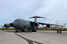
Typhoon Halola was the first significant threat to Wake Island since Hurricane Ioke in 2006, which caused tremendous damage and forced the closure of the island for three months. The Tropical Cyclone Condition of Readiness (TCCOR) level was raised to 3—indicating winds of 93 km/h (58 mph) or higher are possible within 48 hours—by 2:00 p.m. local time on July 14.[29] That day, a Boeing C-17 Globemaster III aircraft from the Hawaii Air National Guard was used to evacuate 125 Department of Defense personnel deployed on Wake Island due to the threat of storm surge. The evacuees were brought to Anderson Air Force Base on Guam.[30][31] The TCCOR was raised to level 2—indicating winds of 93 km/h (58 mph) or higher are expected within 48 hours—on July 15. Warnings were discontinued as the storm weakened and moved away from the island the following day.[29]
Members of the 36th Contingency Response Group and the 353d Special Operations Group were parachuted onto the island on July 18 to conduct damage assessments and clear the airfield of debris.[32] Little, if any, damage was incurred according to their assessments.[33] The airfield was re-opened on July 20 and personnel resumed normal operations.[32]
Japan and South Korea
On July 22, Sasebo Naval Base was placed on alert for possible effects from the approaching typhoon. TCCOR 3 was raised for all United States military bases in Okinawa the next morning. This was subsequently extended on July 24 to cover Sasebo and Marine Corps Air Station Iwakuni while the bases on Okinawa were placed under TCCOR 2. Additionally, TCCOR 4—indicating winds of 93 km/h (58 mph) are possible within 72 hours—was raised for Camp Walker and Chinhae Naval Base in South Korea. During the evening of July 24, TCCOR 1—indicating winds of 93 km/h (58 mph) are expected within 12 hours—was issued for the Okinawa bases. Sasebo Naval Base entered TCCOR 1 late on July 25. Following the storm's degradation into a depression on July 26, all TCCOR levels were dropped or reduced.[29] More than 100 flights to and from Naha Airport were cancelled, affecting approximately 16,000 passengers, with All Nippon Airways comprising the majority of affected flights.[29] Eight flights to and from Kumejima were also canceled.[34] The JMA warned residents across Kyushu to be on alert for flooding.[35]
Owing to the typhoon's northward turn, Okinawa was largely spared noticeable impact. Sustained winds at Kadena Air Base reached 48 km/h (30 mph) with gusts reaching 69 km/h (43 mph).[29] East of Okinawa in the Daitō Islands, sustained winds reached 114 km/h (71 mph) on Minamidaitōjima with a gust of 157 km/h (98 mph); both values were the highest in relation to the storm on land. Similar winds were recorded on Amami Ōshima, situated between Okinawa and Kyushu. Torrential rains affected portions of the archipelago, with Isen, Tokunoshima, recording record-breaking accumulations. Twenty-four-hour totals reached 444 mm (17.5 in), including 114.5 mm (4.51 in) in one hour and 258.5 mm (10.18 in) in three hours; all three values were record amounts since the station began observations in 1977 and considered a 1-in-50 year event.[1][36] Rainfall reached 109 mm (4.3 in) on Okinoerabujima.[37] Ironically, Halola helped suppress rainfall across the majority of mainland Japan by severing a plume of moisture previously bringing several days of heavy rain. Most areas across western Japan received modest rainfall from the dissipating storm.[1]
Throughout the Daitō Islands, sugarcane farms were significantly affected by Typhoon Halola, resulting in ¥154 million (US$1.2 million) in damage.[38] The heavy rains on Tokunoshima prompted the evacuation of 7,500 residents and flooding damaged 90 homes.[1][39] Multiple landslides were reported on the island.[39] Power outages took place on Kitadaitōjima and Minamidaitō.[40] A landslide in Kunigami forced the closure of National Route 331.[41] In mainland Japan, one person was injured in Kumamoto Prefecture, Kyushu, after falling from a roof.[42] In Akita Prefecture, Honshu, river levees were breached by heavy rain brought on by the combination of a weather front and the remnants of Halola.[43][44]
See also
References
- 1 2 3 4 Nick Wiltgen (July 27, 2015). "Typhoon Halola Reaches End of 17-Day Journey Through Pacific (Recap)". Atlanta, Georgia: The Weather Channel. Retrieved December 23, 2015.
- ↑ "Track file of Typhoon 01C (Halola)" (TXT). U.S. Naval Research Laboratory. Retrieved July 25, 2015.
- 1 2 Birchard, Tom. "Tropical Depression One-C Discussion Number 1". Central Pacific Hurricane Center. Retrieved July 25, 2015.
- ↑ Burke, Bob. "Tropical Storm Halola Discussion Number 4". Central Pacific Hurricane Center. Retrieved July 25, 2015.
- ↑ Typhoon Halola (RSMC Tropical Cyclone Best Track). Japan Meteorological Agency. August 25, 2014. Archived from the original on August 25, 2014. Retrieved August 29, 2014.
- ↑ "Tropical Storm Halola Discussion Number 11". Central Pacific Hurricane Center. Retrieved July 25, 2015.
- ↑ "RSMC Tropical Cyclone Advisory 130000". Japan Meteorological Agency. Archived from the original on July 13, 2015. Retrieved July 25, 2015.
- ↑ "RSMC Tropical Cyclone Advisory 140000". Japan Meteorological Agency. Archived from the original on July 14, 2015. Retrieved July 25, 2015.
- ↑ "Prognostic Reasoning for Typhoon 01C (Halola) Warning Nr 16". Joint Typhoon Warning Center. Archived from the original on July 14, 2015. Retrieved July 25, 2015.
- ↑ "Prognostic Reasoning for Typhoon 01C (Halola) Warning Nr 20". Joint Typhoon Warning Center. Archived from the original on July 15, 2015. Retrieved July 25, 2015.
- ↑ "RSMC Tropical Cyclone Advisory 161800". Japan Meteorological Agency. Archived from the original on July 16, 2015. Retrieved July 25, 2015.
- ↑ "Prognostic Reasoning for Tropical Storm 01C (Halola) Warning Nr 27". Joint Typhoon Warning Center. Archived from the original on July 16, 2015. Retrieved July 25, 2015.
- ↑ "Prognostic Reasoning for Tropical Depression 01C (Halola) Warning Nr 32". Joint Typhoon Warning Center. Archived from the original on July 18, 2015. Retrieved July 25, 2015.
- ↑ "RSMC Tropical Cyclone Advisory 180600". Japan Meteorological Agency. Archived from the original on July 18, 2015. Retrieved July 25, 2015.
- ↑ "RSMC Tropical Cyclone Advisory 200000". Japan Meteorological Agency. Archived from the original on July 20, 2015. Retrieved July 25, 2015.
- ↑ "Prognostic Reasoning for Tropical Storm 01C (Halola) Warning Nr 40". Joint Typhoon Warning Center. Archived from the original on July 20, 2015. Retrieved July 25, 2015.
- ↑ "RSMC Tropical Cyclone Advisory 200600". Japan Meteorological Agency. Archived from the original on July 20, 2015. Retrieved July 25, 2015.
- ↑ "RSMC Tropical Cyclone Advisory 210000". Japan Meteorological Agency. Archived from the original on July 21, 2015. Retrieved July 25, 2015.
- ↑ "Prognostic Reasoning for Tropical Storm 01C (Halola) Warning Nr 44". Joint Typhoon Warning Center. Archived from the original on July 21, 2015. Retrieved July 25, 2015.
- ↑ "Prognostic Reasoning for Typhoon 01C (Halola) Warning Nr 45". Joint Typhoon Warning Center. Archived from the original on July 21, 2015. Retrieved July 25, 2015.
- ↑ "RSMC Tropical Cyclone Advisory 211200". Japan Meteorological Agency. Archived from the original on July 21, 2015. Retrieved July 25, 2015.
- ↑ "Prognostic Reasoning for Typhoon 01C (Halola) Warning Nr 49". Joint Typhoon Warning Center. Archived from the original on July 22, 2015. Retrieved July 25, 2015.
- ↑ "Prognostic Reasoning for Typhoon 01C (Halola) Warning Nr 51". Joint Typhoon Warning Center. Archived from the original on July 22, 2015. Retrieved July 25, 2015.
- ↑ "Tropical Cyclone Alert: Typhoon "Goring" Severe Weather Bulletin #1". Philippine Atmospheric, Geophysical and Astronomical Services Administration. Archived from the original on July 23, 2015. Retrieved July 29, 2015.
- ↑ "Prognostic Reasoning for Typhoon 01C (Halola) Warning Nr 53". Joint Typhoon Warning Center. Archived from the original on July 23, 2015. Retrieved July 25, 2015.
- ↑ "Prognostic Reasoning for Typhoon 01C (Halola) Warning Nr 57". Joint Typhoon Warning Center. Archived from the original on July 24, 2015. Retrieved July 25, 2015.
- ↑ "平成27年 台風第12号に関する情報 第94号" (in Japanese). Japan Meteorological Agency. Archived from the original on July 26, 2015. Retrieved July 26, 2015.
- ↑ "平成27年 台風第12号に関する情報 第96号" (in Japanese). Japan Meteorological Agency. Archived from the original on July 26, 2015. Retrieved July 26, 2015.
- 1 2 3 4 5 Dave Ornauer (July 25, 2015). "Pacific Storm Tracker: [Typhoon Halola]". Stars and Stripes. Retrieved December 23, 2015.
- ↑ "Total force effort ensures successful typhoon evacuation". Anderson Air Force Base, Guam: Pacific Air Forces. July 15, 2015. Retrieved December 23, 2015.
- ↑ Senior Airman Orlando Corpuz (July 17, 2015). "Total force effort ensures successful typhoon evacuation". Joint Base Pearl Harbor–Hickam, Hawaii: 154th Wing. Retrieved December 23, 2015.
- 1 2 "353rd SOG collaborates with 36th CRG to open Wake Island airfield". Wake Island: Defense Media Activity. Defense Video & Imagery Distribution System. July 20, 2015. Retrieved December 23, 2015.
- ↑ Senior Airman Alexander W. Riedel (July 22, 2015). "Contingency response Airmen assist in Wake Island storm recovery". Wake Island: United States Air Force. Retrieved December 23, 2015.
- ↑ "台風12号:久米島、鹿児島便など船の欠航8便". Okinawa Times (in Japanese). July 26, 2015. Retrieved December 23, 2015.
- ↑ "台風12号、熱帯低気圧に 長崎・佐世保に上陸後" (in Japanese). 朝日新聞. July 26, 2015. Retrieved December 23, 2015.
- ↑ "台風12号 徳之島で「50年に1度」の記録的大雨 伊仙町で1時間に114ミリ" (in Japanese). 産経ニュース. July 25, 2015. Retrieved December 23, 2015.
- ↑ Kristina Pydynowski (July 27, 2015). "Halola Weakens, Bringing Rain to Japan". AccuWeather. Retrieved December 23, 2015.
- ↑ "台風12号、キビ被害1億5400万 南北大東". Ryūkyū Shimpō (in Japanese). July 28, 2015. Retrieved July 29, 2015.
- 1 2 "台風12号 徳之島町で浸水被害90棟". Yomiuri Shimbun (in Japanese). July 27, 2015. Retrieved December 23, 2015.
- ↑ "大雨・暴風 大東と沖縄本島の生活に影響" (in Japanese). Okinawa Times. July 26, 2015. Retrieved December 23, 2015.
- ↑ "国頭林道2ヵ所、台風で土砂崩れ 東村国道、復旧進まず" (in Japanese). Ryūkyū Shimpō. July 28, 2015. Retrieved December 23, 2015.
- ↑ "台風12号、熱帯低気圧に". 産経ニュース. July 27, 2015. Retrieved December 23, 2015.
- ↑ "平成27年台風第12号による大雨等に係る被害状況等について" (PDF). 内閣府. July 27, 2015. Retrieved July 30, 2015.
- ↑ "県内大雨、斉内川の堤防決壊 JRダイヤも混乱". 秋田魁新報社. July 25, 2015. Retrieved July 30, 2015.
External links
| Wikimedia Commons has media related to Typhoon Halola. |
- Product Archive of Tropical Storm Halola from the Central Pacific Hurricane Center
- JMA General Information of Typhoon Halola (1512) from Digital Typhoon
- 01C.HALOLA from the U.S. Naval Research Laboratory
Tropical cyclones of the 2015 Pacific hurricane season | ||
|---|---|---|
 | ||
| ||
Tropical cyclones of the 2015 Pacific typhoon season | |||||||||||||||||||||||||||||||||||||||||||||||||||||||||||||||||||||||||||||||||||||||||||||||||||||||||||||||||||||||
|---|---|---|---|---|---|---|---|---|---|---|---|---|---|---|---|---|---|---|---|---|---|---|---|---|---|---|---|---|---|---|---|---|---|---|---|---|---|---|---|---|---|---|---|---|---|---|---|---|---|---|---|---|---|---|---|---|---|---|---|---|---|---|---|---|---|---|---|---|---|---|---|---|---|---|---|---|---|---|---|---|---|---|---|---|---|---|---|---|---|---|---|---|---|---|---|---|---|---|---|---|---|---|---|---|---|---|---|---|---|---|---|---|---|---|---|---|---|---|---|
 |
| ||||||||||||||||||||||||||||||||||||||||||||||||||||||||||||||||||||||||||||||||||||||||||||||||||||||||||||||||||||||
| |||||||||||||||||||||||||||||||||||||||||||||||||||||||||||||||||||||||||||||||||||||||||||||||||||||||||||||||||||||||