Tung Lung Chau
| 東龍洲 | |
|---|---|
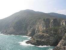
 Aerial view from Northeast | |
 Map of Hong Kong showing the location of Tung Lung Chau. | |
| Geography | |
| Location | Clear Water Bay |
| Area | 2.42 km2 (0.93 sq mi) |
| Highest elevation | 232 m (761 ft) |
| Administration | |
| Tung Lung Chau | |||||||||
| Traditional Chinese | 東龍洲 | ||||||||
|---|---|---|---|---|---|---|---|---|---|
| Literal meaning | Eastern dragon island | ||||||||
| |||||||||
| Nam Tong Island | |||||||||
| Traditional Chinese | 南堂島 | ||||||||
| |||||||||


Tung Lung Chau (Chinese: 東龍洲), also known as Nam Tong Island (南堂島) is an island located off the tip of the Clear Water Bay Peninsula in the New Territories of Hong Kong. It is also referred by Hong Kong people as Tung Lung To or Tung Lung Island (東龍島). The island is largely uninhabited. Administratively, it belongs to Sai Kung District.
Geography
The island has an area of 2.42 square kilometres (0.93 square miles).[1] It forms the eastern boundary of Tathong Channel, which leads into Victoria Harbour through Lei Yue Mun. The northern tip of Tung Lung Chau is separated from the southern tip of Clear Water Bay Peninsula by the narrow Fat Tong Mun Channel (佛堂門). The highest point of the island is at Nam Tong Teng (南堂頂), at an altitude of 232m.
History
Emperor Duanzong of the Southern Song Dynasty once stayed at Kwu Tap (古塔) on the island.[2]
Sights
Tung Lung Chau is the site of Tung Lung Fort, which was constructed 300 years ago and recently refurbished. A prehistoric stone carving can also be found on the island. Measuring 180 cm by 240 cm, it is the largest ancient rock carving in Hong Kong.[3] Both the fort and the stone carving are declared monuments of Hong Kong.
Tung Lung Fort Special Area was designated as a Special Area under country parks in 1979 and covers 3 hectares. The area contains the fort and a campsite.[4][5]
Rock climbing
Tung Lung houses some of the best sport climbing venues in Hong Kong.[6]
- Technical Wall
- Sea Gully Wall
Transportation

On weekends, kai-to service is available from Sam Ka Tsuen, near Lei Yue Mun (Kowloon side) and is operated by Coral Sea Ferry. The round-trip fare for the 30-minute journey was HK$45 in January 2015.
A service from Sai Wan Ho was operated by Lam Kee Ferry until 26 January 2014 and, after a hiatus of eight months, another operator resumed the service for a round-trip fare of HK$55 for adults and HK$40 for children aged 3 and above.[7]
See also
| Wikimedia Commons has media related to Tung Lung Chau. |
- Islands of Hong Kong
- March of Tung Lung To
References
- ↑ Survey and Mapping Office, Lands Department: Hong Kong geographic data sheet
- ↑ Jen, Yu-wen (1967). "The Travelling Palace of Southern Sung in Kowloon" (PDF). Journal of the Royal Asiatic Society Hong Kong Branch. 7: 21–38. ISSN 1991-7295.
- ↑ Antiquities and Monuments Office: Rock Carving on Tung Lung Island
- ↑ Tung Lung Chau Campsite
- ↑ Country Parks & Special Areas
- ↑ Hong Kong Climbing
- ↑ 吳卓恆 (26 January 2014). "政府無資助 林記街渡告別東龍". inmediahk.net.
Coordinates: 22°14′57″N 114°17′23″E / 22.24917°N 114.28972°E