Transport in Brisbane
Transport in Brisbane, the capital and largest city of Queensland, Australia, is provided by road, rail, river and bay ferries, footpaths, bikepaths, sea and air.
Transport around Brisbane is managed by both the Brisbane City Council and the Government of Queensland, which owns Queensland Rail. Public commuter rail transport is operated by Queensland Rail, through its City network system. Road transport is via the standard residential street network managed by Brisbane City Council and the connecting arterial road network which is managed by Queensland Main Roads. The public bus transport system is operated by the Brisbane City Council, and uses the road network as well as dedicated bus lanes and busways. Public transport on and across the Brisbane River is provided by the Cityferry (inner city) and CityCat services run by the Brisbane City Council.
Transport in and out of Brisbane is managed by both public and private enterprises. Queensland Rail manages a freight and passenger service inter-city and interstate. Queensland Main Roads manages the Queensland road network. Port of Brisbane is a private company that provides bulk sea freighter facilities. Brisbane Airport Corporation Limited manages the Brisbane Airport which has both domestic and international terminals with both freight and passenger services.
Transport information
Transport information can be obtained from TransLink, by visiting the Transit window of the Queen Street Mall information centre, or the Transport Information Centre just off King George Square. Brisbane City Council also has an interactive mapping feature on their website showing cycle routes and bikeways.
Cycling
Brisbane is constructing a number of cycle routes and dedicated, off-road bikeways. The South-East Bikeway is a bicycle only bikeway running adjacent to the South East Freeway. It empties onto the Goodwill Bridge at South Bank, which in turn, connects with the Bicentennial Bikeway underneath the Riverside Expressway. The Bicentennial Bikeway continues along the Brisbane River to Toowong.
A limited number of buses used to carry cycle racks on the front but this service is no longer available. Bicycles are easy to transport on the CityCats, and many stops have bicycle racks. During peak hour, bicycles on Queensland Rail's (QR) City network services are restricted to counter-peak-flow services (i.e. You have to be travelling away from the city in the morning, and to the city in the afternoon). Exceptions to this are relatively uncommon such as fold up bicycles fitting within certain dimensions. Riding a bicycle on QR property is always forbidden.
A bike station in the King George Square busway station offers many amenities including showers and locker rooms for members.[1] Subscriptions for a Velib style community bike hire scheme called citycycle by JCDecaux for Brisbane started on 1 September 2010 with bikes available from 1 October 2010 at 150 stations from the University of Queensland to Teneriffe.[2]
Public transport
Brisbane's public transport system is provided by rail, buses, ferries and taxis. A large tram network finally closed in 1969. A smaller trolley-bus system closed at the same time, routes on both systems being replaced by buses.
TransLink is a division of the Queensland Government's Department of Transport and Main Roads. It manages the planning, co-ordination, integrated ticketing and zoning for public transport services covering Brisbane and the rest of South East Queensland. public transport services in the South-East Queensland region. It contracts Queensland Rail, private bus operating companies and Brisbane Transport to operate public transport services in allocated operating areas for a negotiated price, and keeps all fare receipts. Passengers pay common fares, based on the number of zones travelled through, on all the public transport modes covered - trains, buses and ferries, irrespective of who operates the service. In 2007, Translink introduced a smartcard-based ticketing system, the "go card". Paper tickets are still available, but travel using the go card costs significantly less than using a paper ticket.
Rail services are operated by Queensland Rail. The bus system for the Brisbane bus operational area, the high-speed CityCat, and the cross-river CityFerry and City Hopper ferries are operated by Brisbane Transport, a business arm of the Brisbane City Council. Contracted buses that serve the regional areas outside and across the Brisbane boundary are operated by private companies.
After some years of decline, Brisbane's public transport system is being revitalised and finding greater patronage, with significant investment in railway station upgrades, busways, reorganised bus routes and new buses. However, patronage remains a far cry from public transport's heyday in the 1940s, when the tram system alone carried 160 million passengers annually. By comparison, Brisbane Transport buses carried 53 million passengers in 2005, although Brisbane's population has doubled since the 1940s. This figure climbed to 77 million in 2010.[3]
The CBD is the hub for all public transport: Queen Street bus station for buses, Roma Street and Central stations for trains, and North Quay for ferries. Various smaller transfer hubs, such as the Cultural Centre busway station, are located at various strategically placed points of public importance and public interest in the city, including the Queensland Cultural Centre, South Bank Parklands and shopping malls, which are usually within dense population centres. Many busway stations are co-located with (e.g. Roma Street station) or are near to train stations (e.g. Cultural Centre bus station and South Brisbane railway station), facilitating transfers between modes.
In December 2005, TransLink began all-night public transport services on Friday and Saturday nights, under the name of NightLink. These bus routes have numbers prefixed with the letter N, and often carry security guards. The Beenleigh, Ipswich and Caboolture rail lines also operate into the early morning hours.
Buses

go Brisbane City Council operates Most of its suburban and urban bus services under the TransLink integrated public transport scheme. TransLink is responsible for all timetabling and ticketing on Brisbane City Council (Brisbane Transport) buses, which Brisbane Transport constructs, leases back (a sell and leaseback scheme operating between the Council and State) and operates.
Buses generally operate on a 5 am to midnight timetable throughout the week, with some Friday and Saturday night 24-hour services. This puts the bus network out of the reach of early morning shift workers (e.g. 2am-4am). In addition to the local bus routes, most routes in Brisbane are express (CityXpress) and don't observe minor stops. Buses on some routes, prefixed with a P, accept no cash, only pre-purchased tickets or go cards.
BUZ (Bus Upgrade Zones) are high-frequency express routes, pioneered by Brisbane City Council, that provide services on main corridors at least every 15 minutes on any day of the week from 6am to 11pm.[4]
During peak hours, 'Rocket' buses bypass most intermediate stops, while 'Bullets' (such as the Browns Plains 142) don't stop between the CBD and their final destinations.
The CityGlider is a high-frequency route operating between Newstead and West End via the CBD. The Maroon [City]Glider operates between Ashgrove and Stones Corner via South Bank. Other CityGlider routes are planned. CityGlider services require prepaid tickets (i.e. go cards). They use branded buses stopping only at specified CityGlider stops, and run every 5 minutes in peak hours and every 10 to 15 minutes outside peak hours.[5]
The 'Great Circle Line' bus routes operate on a large anti-clockwise (route 598) and clockwise (route 599) loop around Brisbane's outer suburbs. They are used for travel between suburbs, particularly the larger shopping centres, without the need to travel through the CBD.
Buses often provide free transport between major shopping centres (for example Westfield Carindale) and The Gabba stadium or Suncorp Stadium for sporting match events.
The free City Loop and Spring Hill Loop bus services provide high-frequency public transport access within the Brisbane CBD, and between the Brisbane CBD and Spring Hill. The City Loop operates clockwise and anti-clockwise in the Brisbane CBD from designated red-sign bus stops, using distinctive red buses. The Spring Hill Loop operates on a continuous loop between the CBD and Spring Hill, stopping at yellow-sign bus stops, using distinctive yellow buses.
The 'Brisbane Explorer' (superseding the 'City Sights' services) is a non-TransLink prepaid hop-on, hop-off service that visits Brisbane's landmarks, including Mt Coot-tha, on a two-hour journey.
During the Christmas period, a special 'Christmas Lights' service operates (tickets must be pre-purchased), often with buses decked inside with Christmas decorations.
A busway network has been constructed to provide public transport access to areas in the northern, eastern, and south-eastern corridors of the city beyond the reach of the metropolitan train lines. Busways are roads dedicated to buses only. Brisbane's three busways are the South East Busway, the Northern Busway and the Eastern Busway.
Rail

The large Queensland Rail City network consists of seven suburban lines covering mostly the south-west, north and outer east sides of the city. It also provides part of the route for the Airtrain service between the City and Brisbane Airport (the Airtrain route itself being owned by a private company). interurban services also extend to the hinterlands of both the Gold Coast and the Sunshine Coast.
On 24 March 2010, Queensland Premier Anna Bligh announced in Parliament that a new 19 kilometres (12 mi) Cross River Rail tunnel connecting Salisbury to Wooloowin was under consideration.[6] The project was scrapped by the incoming Liberal National Party of Queensland government of Newman, to be replaced by the BaT Tunnel. This project, in turn, was cancelled in March 2015 by the Australian Labor Party government of Palaszczuk,[7] which is intending to reintroduce a version of the Cross River Rail.
River


CityCat and CityFerry are ferry services operated on the Brisbane River by Transdev Brisbane Ferries, a joint venture of Brisbane City Council and French company Transdev. CityCats are catamarans. The area covered by the CityFerry services differs in being smaller with stops spaced closer together, and is operated with 12 monohull ferries, varying slightly in appearance from one another.
The CityCats' busiest day is Sunday, many residents and visitors using it as a very inexpensive (free, if used as part of a longer TransLink journey) way to sightsee.
Taxis
Two cab companies operate in Brisbane: Yellow Cabs (whose vehicles are painted orange), and Black and White Cabs. Both companies offer services under the same fare system (regulated by the Queensland government). They may pick up passengers from anywhere in the metropolitan and regional areas of Brisbane via casual or permanent bookings cab ranks. As well as standard taxis, both provide Maxi-Taxis designed to accommodate up to 10 people, and with disability access. They also operate luxury vehicles (Silver Service for Yellow, Business Class for Black and White). All cabs now are also fitted with GPS tracking systems for driver location and have debit/credit card EFTPOS facilities.
Roads
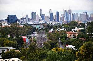
Brisbane's road system was planned around large, spacious suburban areas. Dense suburbs now rely on several main road corridors that split through and between these areas and provide the only link to the CBD and other areas of Brisbane. Logan Road, Moggill Road, Old Cleveland Road and Gympie Road are but a few of these multi-lane corridors that come out of the CBD and snake through the suburbs. As a result, traffic congestion has become a major problem and it was the promise of a new underground road system, nicknamed TransApex, that helped former Lord Mayor Campbell Newman win the 2004 local government election.

Bypasses such as the Inner City Bypass, Clem Jones Tunnel, and the Airport Link are intended to help to circulate traffic away from the inner-city areas and main roads via limited-access roads above the ground, and tunnels below that have higher speed limits and exits to particular suburbs. Existing high speed cross-suburban motorways such as the Western Freeway, Centenary Freeway, Pacific Motorway and Gateway Motorway provide alternative routes to main roads and connect up to main highways and other arterial roads. Other tunnels are also being planned to link all the various motorways in Brisbane together as part of TransApex, but only two have been scheduled for completion within the next decade.
In total, the twisting Brisbane River is crossed by seven road bridges, a road tunnel, three railway bridges, three pedestrian bridges and a dedicated bus, cycle and pedestrian bridge. Route signage is achieved by means of a system of Metroads, consisting of the most important arterial roads in metropolitan Brisbane including most motorways, and less important State Routes. Multiple freeways connect Brisbane to other cities, including the Pacific Motorway, the Bruce Highway and the Ipswich Motorway, all of which are part of the National Highway System. Brisbane is approximately 1,000 km away from Sydney, the closest major capital city.
Airports

Brisbane Airport, owned by the Brisbane Airport Corporation Limited and located north-east of the city centre, is the biggest airport in Australia in terms of land size.[8] Brisbane Airport is the third busiest airport in the country behind Sydney and Melbourne Airports respectively. Separated into domestic and international terminals, Brisbane Airport has frequent passenger and freight flights, providing direct flights to every capital city in Australia as well as many destinations in Asia, Oceania, and the Middle East. Virgin Australia, the second largest airline in Australia, is headquartered in Brisbane, while other major airlines Qantas and Jetstar Airways both fly from Brisbane Airport.
The Airtrain provides a link between the Domestic and International Terminals at Brisbane Airport and the city, taking approximately 20 minutes to travel from Central Station to the Airport stations.
Archerfield Airport, located in Brisbane's southern suburbs, caters to general aviation. Other local airports can be found at Caboolture and Redcliffe.
Seaports

The Port of Brisbane is on the lower reaches of the Brisbane River and on Fisherman's Island at the river's mouth; it is the 3rd most important port in Australia for value of goods.[9] Container freight, sugar, grain, coal and bulk liquids are the major exports. Most of the port facilities are less than three decades old, and some are built on reclaimed mangroves and wetlands. Historically, Brisbane's port facilities were located as far upstream as the central business district.
The economic region near the river's mouth including the port, airport and refineries is known as the Australia TradeCoast.
Historic
Historically Brisbane had a network of trolleybuses and trams, both of which were closed in 1969 in favour of an expanded bus fleet.
The Brisbane Tramways Trust experimented with providing bus services in the 1920s but these proved impractical due to mechanical unreliability and Brisbane's poor road surface quality. The first permanent bus services were introduced in 1940 as a supplement to Brisbane's tram services. In 1948 the council municipalised a number of privately run bus operators and expanded its own fleet of buses. The first tram lines to close were the Lower Edward Street to Gardens route, and the Upper Edward Street to Gregory Terrace route in 1947, the latter due to the very steep grades on that line. Diesel-engined buses initially replaced tram services on these lines, however these were replaced by Trolleybuses on 12 August 1951.
The council also intended to introduce a trolleybus service to the new University of Queensland campus at St Lucia, and purchased enough trolleybus chassis from the United Kingdom for the route. However, it was vigorously opposed by residents and the plan was abandoned. The council then found itself with surplus trolleybuses but no route on which to run them, so it decided to run the trolleybuses from Herston to Stanley Bridge, East Brisbane, commencing in 1952. Several other trolleybus routes were subsequently established in the eastern suburbs. The first of these replaced a tram route, along Cavendish Road, in 1955. Other trolleybus routes to Seven Hills and Carina did not involve tram route closures. The depot and workshops for the trolleybuses was located in Milton on Milton Road between Hale and Castlemaine Streets. The former depot was demolished to make way for the redeveloped Suncorp Stadium.
The tramway closure was notable for the speed with which it was carried out. Several hundred replacement buses were purchased from British vehicle manufacturer Leyland, at the time the largest single bus purchase in the world. The sudden acquisition of so many buses was to have repercussions in later years. Initially the Leyland Panther buses proved unreliable, and as a result, older front-engined mounted buses such as the Leyland Mk III Regals, dating from the 1940s, were retained well past their normal replacement date. Once the problems with the Panthers were ironed out, overall fleet numbers and maintenance requirements were reduced. Nevertheless, the fleet retained many older buses from the 1950s and early 1960s.
In 1975, the Whitlam Labor federal government made $80 million available to the Bjelke-Petersen National Party Queensland state government, intended to be passed on to Brisbane City Council for the purchase of new, replacement buses. The government refused to transfer the funds to the council, instead using the money to restore Parliament House and construct the Parliamentary Annexe building. As the replacement bus fleet aged, their maintenance requirements steadily increased, at a time when labour and spare parts costs had risen sharply. Further, as the tram replacement buses started to wear out at about the same time and needed replacement, the council was faced with another large capital outlay. Subsequently in 1976, the council was able to negotiate federal funding, enabling them to purchase Volvo B-59M buses, its first fleet acquisitions in seven years.
Patronage on the buses continued to decline, despite the best efforts of the Department of Transport hampered by rising fuel and labour costs, together with tightening budgets, leading to further cuts in services. An ageing bus fleet, some of which had been in service since the 1940s, made the service increasingly unattractive. A further hindrance was the council's own aggressively pro-car 1964 City Plan, requiring all developments to include car parking, but did not require the provision of any facilities that might advantage public transport. By the 1980s, the decline in patronage was halted, although costs continued to outstrip ticket revenue.
Future infrastructure
Brisbane's population growth has seen great strains placed upon South East Queensland's transport system. The State Government and Brisbane City Council have responded with infrastructure plans and increased funding for transportation projects, such as the South East Queensland Infrastructure Plan and Program. Most of the focus has been placed on expanding current road infrastructure, particularly tunnels and bypasses, as well as improving the public transport system.
UBAT
The Queensland Government is working with Brisbane City Council to deliver the Underground Bus and Train (UBAT) project. UBAT involves a5km double decked tunnel carrying busses above trains through three new stations under the CBD and Brisbane River. Works are scheduled to be completed by 2020. The project will double the public transport capacity across the Brisbane River, providing faster and more reliable trips across the region.
See also
References
- ↑ cycle2city
- ↑ CityCycle Brisbane
- ↑ Daniel Hurst (20 May 2011). "Bus overcrowding worse than ever". Brisbane Times. Fairfax Media. Retrieved 17 June 2011.
- ↑ BUZ services. Brisbane City Council. Retrieved on 3 June 2011.
- ↑ CityGlider services. Brisbane City Council. Retrieved on 3 June 2011.
- ↑ "New Brisbane rail tunnel under consideration". Australia Times. 24 March 2010. Retrieved 25 March 2010.
- ↑ Tony Moore (6 March 2015). "BaT tunnel scrapped as government looks for different cross river rail line". Brisbane Times. Fairfax Media. Retrieved 16 August 2015.
- ↑ "Our Company". Brisbane Airport Corporation. Retrieved 16 August 2015.
- ↑ Australian Sea Freight Australian Department of Transport and Regional Services Archived 27 April 2006 at the Wayback Machine.
External links
![]() Media related to Transport in Brisbane at Wikimedia Commons
Media related to Transport in Brisbane at Wikimedia Commons