Tournecoupe
| Tournecoupe | ||
|---|---|---|
|
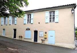
Town hall | ||
| ||
 Tournecoupe | ||
|
Location within Occitanie region  Tournecoupe | ||
| Coordinates: 43°51′50″N 0°48′42″E / 43.8639°N 0.8117°ECoordinates: 43°51′50″N 0°48′42″E / 43.8639°N 0.8117°E | ||
| Country | France | |
| Region | Occitanie | |
| Department | Gers | |
| Arrondissement | Condom | |
| Canton | Saint-Clar | |
| Intercommunality | Cœur de Lomagne | |
| Government | ||
| • Mayor (2008–2014) | Gérard Bassau | |
| Area1 | 18.95 km2 (7.32 sq mi) | |
| Population (2008)2 | 283 | |
| • Density | 15/km2 (39/sq mi) | |
| Time zone | CET (UTC+1) | |
| • Summer (DST) | CEST (UTC+2) | |
| INSEE/Postal code | 32452 / 32380 | |
| Elevation |
97–221 m (318–725 ft) (avg. 164 m or 538 ft) | |
|
1 French Land Register data, which excludes lakes, ponds, glaciers > 1 km² (0.386 sq mi or 247 acres) and river estuaries. 2 Population without double counting: residents of multiple communes (e.g., students and military personnel) only counted once. | ||
.svg.png)
Tournecoupe is a commune in the Gers department in southwestern France.
Population
| Historical population | ||
|---|---|---|
| Year | Pop. | ±% |
| 1962 | 469 | — |
| 1968 | 439 | −6.4% |
| 1975 | 416 | −5.2% |
| 1982 | 349 | −16.1% |
| 1990 | 276 | −20.9% |
| 1999 | 267 | −3.3% |
| 2008 | 283 | +6.0% |
See also
References
| Wikimedia Commons has media related to Tournecoupe. |
This article is issued from Wikipedia - version of the 8/16/2016. The text is available under the Creative Commons Attribution/Share Alike but additional terms may apply for the media files.