Cazaubon
| Cazaubon | ||
|---|---|---|
 | ||
| ||
 Cazaubon | ||
|
Location within Occitanie region  Cazaubon | ||
| Coordinates: 43°56′08″N 0°04′14″W / 43.9356°N 0.0706°WCoordinates: 43°56′08″N 0°04′14″W / 43.9356°N 0.0706°W | ||
| Country | France | |
| Region | Occitanie | |
| Department | Gers | |
| Arrondissement | Condom | |
| Canton | Cazaubon | |
| Intercommunality | Grand-Armagnac | |
| Government | ||
| • Mayor (2008–2014) | Claude Sainrapt | |
| Area1 | 55.64 km2 (21.48 sq mi) | |
| Population (2008)2 | 1,651 | |
| • Density | 30/km2 (77/sq mi) | |
| Time zone | CET (UTC+1) | |
| • Summer (DST) | CEST (UTC+2) | |
| INSEE/Postal code | 32096 / 32150 | |
| Elevation |
92–183 m (302–600 ft) (avg. 124 m or 407 ft) | |
|
1 French Land Register data, which excludes lakes, ponds, glaciers > 1 km² (0.386 sq mi or 247 acres) and river estuaries. 2 Population without double counting: residents of multiple communes (e.g., students and military personnel) only counted once. | ||
.svg.png)
Cazaubon is a commune in the Gers department of southwestern France.
Besides the town of Cazaubon itself, the commune includes the adjacent spa town of Barbotan-les-Thermes.
Geography
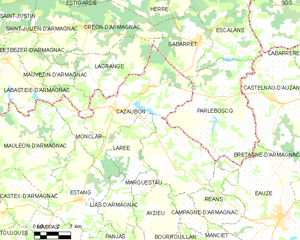
Cazaubon and its surrounding communes
Population
| Historical population | ||
|---|---|---|
| Year | Pop. | ±% |
| 1793 | 2,266 | — |
| 1800 | 1,179 | −48.0% |
| 1806 | 2,371 | +101.1% |
| 1821 | 2,407 | +1.5% |
| 1831 | 2,456 | +2.0% |
| 1841 | 2,657 | +8.2% |
| 1846 | 2,600 | −2.1% |
| 1851 | 2,728 | +4.9% |
| 1856 | 2,691 | −1.4% |
| 1861 | 2,800 | +4.1% |
| 1866 | 2,798 | −0.1% |
| 1872 | 2,666 | −4.7% |
| 1876 | 2,757 | +3.4% |
| 1881 | 2,839 | +3.0% |
| 1886 | 2,845 | +0.2% |
| 1891 | 2,591 | −8.9% |
| 1896 | 2,617 | +1.0% |
| 1901 | 2,520 | −3.7% |
| 1906 | 2,427 | −3.7% |
| 1911 | 2,231 | −8.1% |
| 1921 | 1,877 | −15.9% |
| 1926 | 1,953 | +4.0% |
| 1931 | 1,841 | −5.7% |
| 1936 | 1,778 | −3.4% |
| 1946 | 1,856 | +4.4% |
| 1954 | 1,756 | −5.4% |
| 1962 | 1,701 | −3.1% |
| 1968 | 1,691 | −0.6% |
| 1975 | 1,638 | −3.1% |
| 1982 | 1,635 | −0.2% |
| 1990 | 1,605 | −1.8% |
| 1999 | 1,546 | −3.7% |
| 2008 | 1,651 | +6.8% |
See also
References
| Wikimedia Commons has media related to Cazaubon. |
This article is issued from Wikipedia - version of the 2/20/2016. The text is available under the Creative Commons Attribution/Share Alike but additional terms may apply for the media files.