Tonganoxie, Kansas
| Tonganoxie, Kansas | |
|---|---|
| City | |
 Location within Leavenworth County and Kansas | |
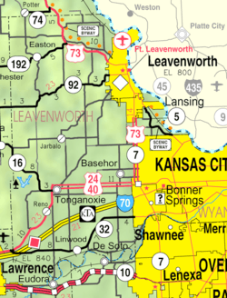 KDOT map of Leavenworth County (legend) | |
| Coordinates: 39°6′32″N 95°5′13″W / 39.10889°N 95.08694°WCoordinates: 39°6′32″N 95°5′13″W / 39.10889°N 95.08694°W | |
| Country | United States |
| State | Kansas |
| County | Leavenworth |
| Area[1] | |
| • Total | 3.67 sq mi (9.51 km2) |
| • Land | 3.66 sq mi (9.48 km2) |
| • Water | 0.01 sq mi (0.03 km2) |
| Elevation | 889 ft (271 m) |
| Population (2010)[2] | |
| • Total | 4,996 |
| • Estimate (2015[3]) | 5,248 |
| • Density | 1,400/sq mi (530/km2) |
| Time zone | Central (CST) (UTC-6) |
| • Summer (DST) | CDT (UTC-5) |
| ZIP code | 66086 |
| Area code | 913 |
| FIPS code | 20-70800 [4] |
| GNIS feature ID | 0478853 [5] |
| Website | Tonganoxie.org |
Tonganoxie (pronounced /tɒŋɡəˈnɒksi/)[6] is a city in Leavenworth County, Kansas, United States. As of the 2010 census, the city population was 4,996.[7]
History
Tonganoxie was platted in 1866.[8][9] It was named for a local Delaware Indian chief whose name means "shorty" in the Delaware language.[10] Tonganoxie was incorporated as a city in the late 1870s.[11]
Geography
Tonganoxie is located at 39°6′32″N 95°5′13″W / 39.10889°N 95.08694°W (39.108880, -95.086885).[12] According to the United States Census Bureau, the city has a total area of 3.67 square miles (9.51 km2), of which 3.66 square miles (9.48 km2) is land and 0.01 square miles (0.03 km2) is water.[1]
Climate
The climate in this area is characterized by hot, humid summers and generally mild to cool winters. According to the Köppen Climate Classification system, Tonganoxie has a humid subtropical climate, abbreviated "Cfa" on climate maps.[13]
Demographics
| Historical population | |||
|---|---|---|---|
| Census | Pop. | %± | |
| 1880 | 426 | — | |
| 1890 | 673 | 58.0% | |
| 1900 | 848 | 26.0% | |
| 1910 | 1,018 | 20.0% | |
| 1920 | 971 | −4.6% | |
| 1930 | 1,109 | 14.2% | |
| 1940 | 1,114 | 0.5% | |
| 1950 | 1,140 | 2.3% | |
| 1960 | 1,354 | 18.8% | |
| 1970 | 1,717 | 26.8% | |
| 1980 | 1,864 | 8.6% | |
| 1990 | 2,347 | 25.9% | |
| 2000 | 2,728 | 16.2% | |
| 2010 | 4,996 | 83.1% | |
| Est. 2015 | 5,248 | [14] | 5.0% |
| U.S. Decennial Census | |||
2010 census
As of the census[2] of 2010, there were 4,996 people, 1,884 households, and 1,338 families residing in the city. The population density was 1,365.0 inhabitants per square mile (527.0/km2). There were 1,973 housing units at an average density of 539.1 per square mile (208.1/km2). The racial makeup of the city was 95.2% White, 1.0% African American, 0.7% Native American, 0.4% Asian, 0.1% Pacific Islander, 0.6% from other races, and 2.0% from two or more races. Hispanic or Latino of any race were 3.8% of the population.
There were 1,884 households of which 41.1% had children under the age of 18 living with them, 52.8% were married couples living together, 12.8% had a female householder with no husband present, 5.5% had a male householder with no wife present, and 29.0% were non-families. 23.8% of all households were made up of individuals and 9.9% had someone living alone who was 65 years of age or older. The average household size was 2.61 and the average family size was 3.08.
The median age in the city was 32.5 years. 29.3% of residents were under the age of 18; 7.7% were between the ages of 18 and 24; 29.9% were from 25 to 44; 21.2% were from 45 to 64; and 11.8% were 65 years of age or older. The gender makeup of the city was 47.9% male and 52.1% female.
2000 census
As of the census[4] of 2000, there were 2,728 people, 999 households, and 737 families residing in the city. The population density was 869.8 people per square mile (335.4/km²). There were 1,032 housing units at an average density of 329.0 per square mile (126.9/km²). The racial makeup of the city was 95.2% White, 1.2% African American, 0.9% Native American, 0.4% Asian, 0.3% Pacific Islander, 0.7% from other races, and 1.4% from two or more races. Hispanic or Latino of any race were 2.3% of the population.
There were 999 households out of which 42.0% had children under the age of 18 living with them, 57.6% were married couples living together, 11.8% had a female householder with no husband present, and 26.2% were non-families. 22.9% of all households were made up of individuals and 11.6% had someone living alone who was 65 years of age or older. The average household size was 2.65 and the average family size was 3.13.
In the city the population was spread out with 30.0% under the age of 18, 9.5% from 18 to 24, 30.0% from 25 to 44, 17.1% from 45 to 64, and 13.4% who were 65 years of age or older. The median age was 32 years. For every 100 females there were 91.8 males. For every 100 females age 18 and over, there were 87.9 males.
The median income for a household in the city was $44,278, and the median income for a family was $49,960. Males had a median income of $37,301 versus $24,028 for females. The per capita income for the city was $18,026. About 4.5% of families and 6.0% of the population were below the poverty line, including 5.5% of those under age 18 and 9.9% of those age 65 or over.
Education
Tonganoxie has one high school, a middle school, and one new elementary school. The high school teams are named the Chieftains, while middle school teams are known as the Warriors and the elementary school's mascot is the Braves.
Economy
Peruvian Connection is based in Tonganoxie.
Notable people
- Danni Boatwright, Sole Survivor of the CBS Series Survivor: Guatemala, Miss Kansas USA 1996
- Connie O'Brien, member of the Kansas House of Representatives
References
- 1 2 "US Gazetteer files 2010". United States Census Bureau. Retrieved 2012-07-06.
- 1 2 "American FactFinder". United States Census Bureau. Retrieved 2012-07-06.
- ↑ "Population Estimates". United States Census Bureau. Retrieved 2016-08-22.
- 1 2 "American FactFinder". United States Census Bureau. Retrieved 2008-01-31.
- ↑ "US Board on Geographic Names". United States Geological Survey. 2007-10-25. Retrieved 2008-01-31.
- ↑ William Allen White School of Journalism and Public Information (1955). A pronunciation guide to Kansas place names. Lawrence, KS: University of Kansas. p. 25.
- ↑ "2010 City Population and Housing Occupancy Status". U.S. Census Bureau. Retrieved March 6, 2011.
- ↑ Hall, Jesse A. and Hand LeRoy T. (1921). History of Leavenworth County Kansas. Historical Publishing Company. p. 152.
- ↑ Kansas State Historical Society (1916). Biennial Report of the Board of Directors of the Kansas State Historical Society. Kansas State Printing Plant. p. 222.
- ↑ Heim, Michael (2007). Exploring Kansas Highways. p. 51.
- ↑ Blackmar, Frank Wilson (1912). Kansas: A Cyclopedia of State History, Volume 2. Standard Publishing Company. p. 810.
- ↑ "US Gazetteer files: 2010, 2000, and 1990". United States Census Bureau. 2011-02-12. Retrieved 2011-04-23.
- ↑ Climate Summary for Tonganoxie, Kansas
- ↑ "Annual Estimates of the Resident Population for Incorporated Places: April 1, 2010 to July 1, 2015". Retrieved July 2, 2016.
Further reading
- County
- History of Leavenworth County Kansas; Jesse Hall and LeRoy Hand; Historical Publishing; 684 pages; 1921. (Download 27MB PDF eBook)
- Kansas
- History of the State of Kansas; William G. Cutler; A.T. Andreas Publisher; 1883. (Online HTML eBook)
- Kansas : A Cyclopedia of State History, Embracing Events, Institutions, Industries, Counties, Cities, Towns, Prominent Persons, Etc; 3 Volumes; Frank W. Blackmar; Standard Publishing Co; 944 / 955 / 824 pages; 1912. (Volume1 - Download 54MB PDF eBook),(Volume2 - Download 53MB PDF eBook), (Volume3 - Download 33MB PDF eBook)
External links
| Wikimedia Commons has media related to Tonganoxie, Kansas. |
Municipalities and communities of Leavenworth County, Kansas, United States | ||
|---|---|---|
| Cities | 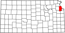 | |
| CDPs | ||
| Unincorporated communities | ||
| Townships |
| |
| Ghost town | ||
| Footnotes | ‡This populated place also has portions in an adjacent county or counties | |
Kansas City metropolitan area's cities and counties | ||
|---|---|---|
| Central city |  | |
| Largest cities (over 100,000 in 2000) | ||
| Medium-sized cities (10,000 to 100,000 in 2000) | ||
| Smaller Cities (between 5,000 and 9,900 in 2010) | ||
| Counties | ||