Thungyai Naresuan Wildlife Sanctuary
| Thungyai Naresuan Wildlife Sanctuary | |
|---|---|
| เขตรักษาพันธุ์สัตว์ป่าทุ่งใหญ่นเรศวร | |
|
IUCN category IV (habitat/species management area) | |
|
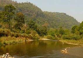
Ramit River at the southern edge of Thungyai Sanctuary bordering Khao Laem National Park | |
 Location in Thailand | |
| Location | Kanchanaburi and Tak Provinces |
| Nearest city | Tak (town) |
| Coordinates | 15°20′00″N 98°55′00″E / 15.33333°N 98.91667°ECoordinates: 15°20′00″N 98°55′00″E / 15.33333°N 98.91667°E |
| Area | 3690 km2 |
| Established | 1974 |
| Governing body | Wildlife Conservation Office |
| Thungyai-Huai Kha Khaeng Wildlife Sanctuaries | |
|---|---|
| Name as inscribed on the World Heritage List | |
| Type | Natural |
| Criteria | vii, ix, x |
| Reference | 591 |
| UNESCO region | Asia-Pacific |
| Inscription history | |
| Inscription | 1991 (15th Session) |
The Thungyai Naresuan Wildlife Sanctuary (Thai: เขตรักษาพันธุ์สัตว์ป่าทุ่งใหญ่นเรศวร) is a protected area in Thailand in the northern part of Kanchanaburi Province and the southern part of Tak Province. It was declared a wildlife sanctuary in 1972 and was declared a World Heritage Site by UNESCO in 1991 together with the adjoining Huai Kha Khaeng Wildlife Sanctuary. [1]
Location and topography
The sanctuary is at the western national border of Thailand with Burma, in the southern area of the Dawna Range. It extends northeast of the Three Pagodas Pass from Sangkhla Buri District (Kanchanaburi Province) into Umphang District (Tak Province).
The wildlife sanctuary stretches over an area of about 369,000 ha and is the largest protected area in Thailand.[2] Together with the adjoining Huai Kha Khaeng Wildlife Sanctuary (Thai: เขตรักษาพันธุ์สัตว์ป่าห้วยขาแข้ง) it constitutes the core area of the western forest complex which represents the largest agglomeration of contiguous protected area in mainland Southeast Asia, 622,200 ha.[1][3]
The area is predominantly mountainous and composed of various limestones interspersed with massive intrusions of granite and smaller outcrops of quartzite and schist. Elevations range from about 180 metres at the Vajiralongkorn Reservoir in the south of the sanctuary to its highest peak, Khao Tai Pa, at 1,811 metres. Major rivers are the Mae Klong and the Mae Chan which originate in the Umphang Wildlife Sanctuary and join in Thungyai into the Upper Khwae Yai which feeds the Si Nakharin Reservoir. Various smaller rivers in the south and southwest feed the Vajiralongkorn Reservoir while in the northwestern part of the sanctuary the Mae Kasat and the Mae Suriya flow into Burma.[4]
Climate and Rainfall
The climate of the region is characterised by three seasons: a hot, wet season from May to October, a cooler, dry period from November to January and a hot, dry season from February to April. Average minimum and maximum daily temperatures range from 20 °C to 33 °C in the wet season, 15 °C to 35 °C in the hot, dry season, and 10 °C to 29 °C in the cooler season. Day-time temperatures can exceed 40° in April while nighttime temperatures of 7 °C are not uncommon in the cool season.
The average annual rainfall decreases from the western part of the sanctuary receiving 2,000 to 2,400 millimetres a year to annual rainfalls of between 1,600 and 2,000 millimetres in the eastern parts of the sanctuary. Over 80 percent of the rain is brought by the southwest monsoon from the Andaman Sea.[5]
Flora and habitat types
Phytogeographically the sanctuary lies at the interface between the terminal southern ridges of the eastern Himalayas and the equatorial forests of the great Sunda Shelf. As most of the sanctuary is botanically unexplored, scientific knowledge about its rich flora is sparse.
montane evergreen forests cover about 15 percent of the sanctuary and occur along the mountain ridges above 1,000 metres where moisture levels are high.
Seasonal or dry evergreen forests are found on about 31 percent of the area, predominantly on land lying between 800-1,000 metres elevation. Gallery evergreen forests occur along permanent watercourses, where humidity is high and the soil perpetually moist. They are often categorized under dry evergreen forests, but are particularly important to the sanctuary's fauna.
Mixed deciduous forest is the most common forest type in Thungyai, covering about 45 percent, predominantly in areas below 800 metres elevation.
Dry dipterocarp forest is a formation unique to mainland Southeast Asia and is found on about one percent of the area.
Savanna forest and grassland covers about four percent, predominantly in the thung yai or "big field" covering about 140 km2 at the centre of the sanctuary.[6]
The remaining four percent of the area are categorized as secondary forests, fallow areas, and swidden fields in the nomination for the World Heritage Site, but include also various bamboo forests which are not included in this classification.[7]
Fauna
Like the flora, the fauna of Thungyai provides a specific mix of species with Sundaic, Indo-Chinese, Indo-Burmese and Sino-Himalayan affinities due to the sanctuary's particular biogeographic location.
Among the mammal species living in Thungyai are lar gibbon (Hylobates lar), various species of macaque (Macaca) und lutung (Trachypithecus), Indochinese tiger (Panthera tigris corbetti), Indochinese leopard (Panthera pardus delacouri), clouded leopard (Neofelis nebulosa), sun bear (Helarctos malayanus) and Asian black bear (Ursus thibetanus), Malayan tapir (Tapirus indicus), Indian elephant (Elephas maximus indicus), gaur (Bos gaurus), hog deer (Cervus porcinus), sambar (Rusa unicolor), Fea's muntjac (Muntiacus feae) und Sumatran serow (Capricornis sumatraensis) as well as many bat species probably including Kitti's hog-nosed bat (Craseonycteris thonglongyai).
Banteng (Bos javanicus) and wild water buffalo (Bubalus amee) are known to occur in the adjoining Huai Kha Khaeng Wildlife Sanctuary and may exist in Thungyai too.
Indications for the occurrence of Vietnamese Javan rhinoceros (Rhinoceros sondaicus annamiticus) and northern Sumatran rhinoceros (Dicerorhinus sumatrensis lasiotis) in the area are recorded from the 1980s, but have not been confirmed since then.[8]
Bird species sighted in Thungyai include white-winged wood duck (Cairina scutulata), kalij pheasant (Lophura leucomelanos), grey peacock-pheasant (Polyplectron bicalcaratum), green peafowl (Pavo muticus), spot-billed pelican (Pelecanus philippensis), Oriental darter (Anhinga melanogaster), painted stork (Mycteria leucocephala), greater adjutant (Leptoptilos dubius), red-headed vulture (Sarcogyps calvus), mountain hawk-eagle (Nisaetus nipalensis), lesser fish eagle (Ichthyophaga humilis) and all six species of hornbill (Bucerotidae) living in mainland Southeast Asia.[9]
The nomination for the two wildlife sanctuaries, Thungyai Naresuan and Huai Kha Khaeng, to become World Heritage Sites[10] lists some 120 species of mammal, 400 birds, 96 reptiles, 43 amphibians, and 113 species of fish, but research on the biodiversity in the sanctuaries is sparse.
History
Paleolithic, Mesolithic and Neolithic stone tools have been found in the Khwae Noi and Khwae Yai river valleys and parts of the sanctuary were inhabited by Neolithic man. For at least 700 years, the Dawna-Tenasserim region has been home to Mon and Karen people, but burial grounds in Thungyai and Huai Kha Khaeng Wildlife Sanctuary have not been systematically researched.[11]
The Thai name "Thungyai Naresuan" refers to the "big field" (thung yai) or savanna in the centre of the sanctuary, and to King Naresuan, a famous Siamese ruler who supposedly based his army in the area to wage war against Burma sometime during his reign of the Ayutthaya Kingdom from 1590 until his death in 1605.[12]
The Karen people who live in the sanctuary call the savanna pia aethala aethea which may be translated as "place of the knowing sage". It refers to the area as a place where ascetic hermits called aethea have lived and meditated and may do so even today. The Karen in Thungyai regard them as holy men important for their history and identity in Thungyai and revere them in a specific cult.[13]
Historical sources as well as local oral tradition suggest that settlement of Karen people in Thungyai did not occur before the second half of the 18th century. At that time, due to political and religious persecution in Burma, predominantly Pwo-Karen from the hinterlands of Moulmein and Tavoy migrated into the area northeast of the Three Pagodas Pass, where they received formal settlement rights from the Siamese Governor of Kanchanaburi. Sometime between 1827 and 1839 the Siamese King Rama III established this area as a principality (mueang) and the Karen leader who governed the principality received the Siamese title of nobility Phra Si Suwannakhiri. During the second half of the 19th century, this Karen principality at the Burmese border became particularly important for the Siamese King Rama V (Chulalongkorn) in his negotiations with the British colonial power in Burma regarding the demarcation of their western border with Siam.[14]
At the beginning of the 20th century, when the modern Thai nation state was established, the Karen in Thungyai lost their former status and importance. During the first half of the 20th century, external political influences were minimal in Thungyai and the Karen communities were highly autonomous regarding their internal affairs. This changed in the second half of the 20th century, when the Thai nation state extended its institutions into the peripheral areas and the Karen re-appeared as chao khao or "hill tribes" on the national political agenda, as forest destroyers and illegal immigrants.[15]
Plans to protect the forests and wildlife at the upper Khwae Yai and Khwae Noi river grew in the mid-1960s. Due to strong logging and mining interests in the area, it was not before 1972 that the Huai Kha Khaeng Wildlife Sanctuary could be established, and Thungyai resistance was even stronger. However, in April 1973 a military helicopter crashed near Thungyai and revealed an illegal hunting party of senior military officers with family members, businessmen, and a film star, arousing nationwide public outrage which finally led to the fall of the Thanom-Prapas Regime after the uprising of 14 October 1973. After this accident and under a new democratic government, the area finally could be declared a wildlife sanctuary in 1974. After the military had taken power once again in October 1976, many of the activists of the democracy movement fled into peripheral regions of the country and some of them found refuge among the Karen people living in Thungyai.[16]
During the 1960s, not only timber and ore, but also the water of the western forests as hydroelectric power resources became of interest for commercial profit and national development. A system of several big dams was planned to produce electricity for the growing urban centres. On the Khwae Yai River the Si Nakharin Dam was finished in 1980 and the Tha Thung Na Dam in 1981, while the Khao Laem Dam (renamed Vajiralongkorn Dam) on the Khwae Noi River south of Thungyai was completed in 1984. The Nam Choan Dam, the last of the projected dams, was supposed to flood a forest area of about 223 km2 within the Thungyai Naresuan Wildlife Sanctuary.
A public dispute about the Nam Choan Dam project lasted for more than six years, dominating national politics and public debate in early-1988 before it was shelved in April that year. Pointing to the high value of Thungyai for nature conservation and biodiversity, dam opponents on the national and international level raised the possibility of declaring the area a world heritage site. This prestigious option would have been lost with a huge dam and reservoir in the middle of the two wildlife sanctuaries most promising to meet the requirements for a global heritage.[17]
After the dam project was shelved, the proposal to UNESCO was written by two persons who had been outspoken opponents in the Nam Choan Controversy and, in December 1991, Thungyai Naresuan together with the adjoining Huai Kha Khaeng Wildlife Sanctuary was declared a Natural World Heritage Site by UNESCO. In the nomination, the "outstanding universal value" of the two sanctuaries is, in first place, justified with their extraordinary high biodiversity due to their unique position at the junction of four biogeographic zones, as well as with its size and "the undisturbed nature of its habitats".[18]
Even though the UNESCO nomination explicitly emphasizes the "undisturbed nature" of the area,[19] and notwithstanding scientific studies supporting traditional settlement and use rights of the Karen people in Thungyai as well as the sustainability of their traditional land use system and their strong intention to remain in their homeland and to protect it,[20] governmental authorities regard the people living in Thungyai as a threat to the sanctuary and pursue their resettlement.
Karen villages in Huai Kha Khaeng were removed when the sanctuary was established in 1972, and in the late-1970s the remaining communities in Huai Kha Khaeng had to leave when the Si Nakharin Dam flooded their settlement areas. During the 1980s and early-1990s, villages of the Hmong ethnic minority group were removed from the Huai Kha Khaeng and Thungyai Naresuan Wildlife Sanctuaries. The resettlement of the remaining Karen in Thungyai was announced in the management plan for the sanctuary, drafted in the late-1980s, as well as in the proposal for the world heritage site. But, when the Thai Royal Forest Department tried to remove them in the early-1990s, it had to reverse the resettlement scheme due to strong public criticism. Since then, the authorities have used repression, intimidation, and terror to convince the Karen to leave their homeland "voluntarily", and placed restrictions on their traditional land use system which will inevitably cause its breakdown and deprive the Karen of subsistence.[21]
Literature
Alongkot Chukaew (1998). Study on botanical knowledge of Karen communities in Thungyai Sanctuary. Bangkok: Wildlife Fund Thailand.
Buergin, Reiner (2000). "Hill tribes and forests: Minority policies and resource conflicts in Thailand". SEFUT Working Paper 7, ISSN 1616-8062. Freiburg: University of Freiburg. http://www.sefut.uni-freiburg.de/pdf/WP_7e.pdf
Buergin, Reiner (2001). "Contested heritages: Disputes on people, forests, and a World Heritage Site in globalizing Thailand". SEFUT Working Paper 9, ISSN 1616-8062. Freiburg: University of Freiburg. http://www.sefut.uni-freiburg.de/pdf/WP_9.pdf
Buergin, Reiner (2002). "Change and identity in Pwo Karen communities in Thung Yai Naresuan Wildlife Sanctuary, a 'Global Heritage' in Western Thailand". SEFUT Working Paper 11, ISSN 1616-8062. Freiburg: University of Freiburg. http://www.sefut.uni-freiburg.de/pdf/WP_11.pdf
Buergin, Reiner (2003a). "Trapped in environmental discourses and politics of exclusion: Karen in the Thung Yai Naresuan Wildlife Sanctuary in the context of forest and hill tribe policies in Thailand". In: Claudio O. Delang (ed.) Living at the edge of Thai Society: The Karen in the highlands of northern Thailand, pp 43–63. London: RoutledgeCurzon. ISBN 0-415-32331-2.
Buergin, Reiner (2003b). "Shifting frames for local people and forests in a global heritage: The Thung Yai Naresuan Wildlife Sanctuary in the context of Thailand's globalization and modernization". Geoforum 34,3: 375-393. http://www.sefut.uni-freiburg.de/pdf/Buergin03.pdf
Buergin, Reiner (2004). Umweltverhältnisse jenseits von Tradition und Moderne. Stuttgart: Ibidem-Verlag. ISBN 3-89821-392-7. http://www.sefut.uni-freiburg.de/pdf/DPub_web.pdf
Chan-ek Tangsubutra; Kulvadee Boonpinon; Mario Ambrosino (1995). "The traditional farming system of the Karen of Sanehpong village, Thung-Yai Naresuan Wildlife Sanctuary, Kanchanaburi Province, Thailand". In: H. Wood, M. McDaniel, K. Warner (eds.): Community development and conservation of forest biodiversity through community forestry, pp. 193–199. Bangkok: RECOFTC. ISBN 974-7315-90-4.
Delang, Claudio O.; Wong, Theresa (2006). "The livelihood-based forest classification system of the Pwo Karen in Western Thailand". Mountain Research and Development 26,2: 138–145.
Kulvadee Boonpinon (1997). Institutional arrangements in communal resource management: A case study of a Karen village in a protected area. M.Sc. Thesis, Faculty of Graduate Studies, Mahidol University, Bangkok.
Seub Nakhasathien, Stewart-Cox, Belinda (1990). Nomination of the Thung Yai - Huai Kha Khaeng Wildlife Sanctuary to be a U.N.E.S.C.O. World Heritage Site. Bangkok: Royal Forest Department.
Steinmetz, Robert (1996). Landscape ecology and wildlife habitats: An indigenous Karen perspective in Thung Yai Wildlife Sanctuary of western Thailand. Bangkok: Wildlife Fund Thailand.
Steinmetz, Robert (1999). "The ecological science of the Karen in Thung Yai Naresuan Wildlife Sanctuary, Western Thailand". In: M. Colchester, C. Erni (eds.): From principles to practice: Indigenous peoples and protected areas in South and Southeast Asia, pp. 84–107. Copenhagen: IWGIA. ISBN 87-90730-18-6.
Steinmetz, Robert; Mather, Robert (1996). "Impact of Karen villages on the fauna of Thung Yai Naresuan Wildlife Sanctuary: A participatory research project". Natural History Bulletin of the Siam Society 44: 23-40.
Steinmetz, Robert; Wanlop Chutipong; Naret Seuaturien (2006). "Collaborating to conserve large mammals in Southeast Asia". Conservation Biology 20,5: 1391-1401.
References
- 1 2 "Thungyai-Huai Kha Khaeng Wildlife Sanctuaries". UNESCO. Retrieved 11 February 2016.
- ↑ http://www.wdpa.org/siteSheet.aspx?sitecode=1405#/area/1405
- ↑ http://www.westernforest.org/en/Default.htm
- ↑ Seub/Stewart-Cox 1990:4.
- ↑ Seub/Stewart-Cox 1990:4-5.
- ↑ Seub/Stewart-Cox 1990:5-11.
- ↑ Seub/Stewart-Cox 1990:11f; Steinmetz 1996.
- ↑ Seub/Stewart-Cox 1990:16-23.
- ↑ Seub/Stewart-Cox 1990:24-26.
- ↑ Seub/Stewart-Cox 1990
- ↑ Seub/Stewart-Cox 1990:32f; Buergin 2004:83.
- ↑ Seub/Stewart-Cox 1990:3f; Buergin 2004:159.
- ↑ Buergin 2003a:43-45; Buergin 2004:226-229.
- ↑ Buergin 2002:7-8; Buergin 2004:83-92.
- ↑ Buergin 2000; Buergin 2004:92-100.
- ↑ Buergin 2001:5-6; Buergin 2004:159-161.
- ↑ Buergin 2003b:385-386; Buergin 2004:161-165.
- ↑ Seub/Stewart-Cox 1990; Buergin 2004:165-168.
- ↑ Seub/Stewart-Cox 1990:47-49.
- ↑ Chan-ek et al. 1995; Steinmetz/Mather 1996; Kulvadee 1997; Alongkot 1998; Steinmetz 1999; Buergin 2002, 2004; Delang/Wong 2006; Steinmetz et al. 2006.
- ↑ Buergin 2003b; Buergin 2004:168-200; http://www.sefut.uni-freiburg.de/buergineng.htm.
External links
| Wikimedia Commons has media related to Thungyai Naresuan Wildlife Sanctuary. |
- UNESCO website for the Thungyai - Huai Kha Khaeng World Heritage Site
- Location and data for the Wildlife Sanctuary Thungyai Naresuan in the World Database on Protected Areas of UNEP and IUCN
- Information regarding ethnic minority people living in the sanctuary
- Pictures from Thungyai
- Information on the Western Forest Complex
- Western Forest Conservation Club
- Kekule, Lawrence Bruce (May 28, 2010). "Thung Yai Naresuan Wildlife Sanctuary". Wildlife Photography in Thailand and Southeast Asia. brucekekule.com. Archived from the original on March 26, 2014.
A look at present-day Thung Yai
| World Heritage Sites |
| |||||||
|---|---|---|---|---|---|---|---|---|
| Tentative List |
| |||||||