Texas State Highway 87
| ||||
|---|---|---|---|---|
 | ||||
| Route information | ||||
| Maintained by TxDOT | ||||
| Length: | 249.39 mi[1] (401.35 km) | |||
| Existed: | by 1939 – present | |||
| Major junctions | ||||
| South end: |
| |||
|
| ||||
| North end: |
| |||
| Highway system | ||||
| ||||

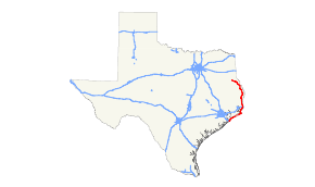
State Highway 87 or SH 87 runs for 249.4 miles (401.4 km) between Galveston, Texas (at a terminus shared with Interstate 45 and Spur 342) to U.S. Highway 59 and U.S. Highway 84 in Timpson, Texas.
Highway 87 has a notable stretch between Sea Rim State Park and High Island, Texas that has been washed out repeatedly over the decades and has been closed continuously since 1990.[2] Portions of this stretch were less than 100 feet (30 m) away from high tide in the 1990s. The storm surge from Hurricane Jerry which made landfall on October 15, 1989, left the highway in a state of disrepair.
While talk about rebuilding the destroyed segment of State Highway 87 happens from time to time (for example, in 1998), there is no serious effort underway to do so.
History

SH 87 was originally designated in 1926[3] from Orange to Milam. The route was the previously proposed SH 8A before being renumbered. By 1928,[4] it extended to Port Arthur. By 1933, it extended again, this time to High Island. In 1939, it was extended to its current terminus in Timpson, and replaced the section of SH 124 from High Island to Galveston. In 1970, road machinery used in its construction accidentally dug up several cannonballs and crumbling kegs of black powder about 10 miles west of Sabine Pass. Further excavation eventually produced more kegs of black powder and several hundred cannonballs. The ammunition had been buried there by Confederate soldiers in what were the ditches of Fort Manhassett in 1865. Fort Manhassett was a series of earthworks constructed by the Confederacy in 1863 to defend the western approaches to Sabine Pass.[5]
Future work
Two ferry routes and up to five ferries, currently operate on Galveston Bay, taking passengers from Port Bolivar to Galveston Island. Because of increasing traffic, especially during summer months, TxDOT was studying the possibility of building a bridge to connect Galveston Island or Pelican Island to the Bolivar Peninsula; however, the decision was made not to build the bridge.
Major intersections
| County | Location | mi | km | Destinations | Notes | ||
|---|---|---|---|---|---|---|---|
| Galveston | Galveston | I-45 exit 1A | |||||
| Bolivar Roads | |||||||
| | |||||||
| | |||||||
| | |||||||
| Gap in route | |||||||
| Jefferson | | McFaddin National Wildlife Refuge | |||||
| | |||||||
| Sabine Pass | |||||||
| Port Arthur | bridge over Gulf Intracoastal Waterway | ||||||
| interchange; south end of SH 73 overlap | |||||||
| interchange | |||||||
| Neches River | Veterans Memorial Bridge / Rainbow Bridge | ||||||
| Orange | Bridge City | ||||||
| Cow Bayou | Cow Bayou Swing Bridge | ||||||
| | north end of SH 73 overlap | ||||||
| | |||||||
| Orange | |||||||
| south end of US 90 Bus. overlap | |||||||
| north end of US 90 Bus. overlap | |||||||
| I-10 exit 877 | |||||||
| south end of FM 3247 overlap | |||||||
| north end of FM 3247 overlap | |||||||
| Newton | | ||||||
| | |||||||
| | |||||||
| | |||||||
| Trout Creek | |||||||
| | |||||||
| Bleakwood | |||||||
| | |||||||
| Newton | |||||||
| | |||||||
| | |||||||
| Burkeville | |||||||
| | |||||||
| Mayflower | |||||||
| Sabine | | ||||||
| | |||||||
| Yellowpine | |||||||
| Hemphill | |||||||
| south end of FM 83 overlap | |||||||
| north end of FM 83 overlap | |||||||
| Milam | |||||||
| Isla | |||||||
| Sexton | |||||||
| Shelby | | ||||||
| | |||||||
| Patroon | |||||||
| | south end of FM 139 overlap | ||||||
| | north end of FM 139 overlap | ||||||
| | |||||||
| Shelbyville | south end of FM 417 overlap | ||||||
| north end of FM 417 overlap | |||||||
| | |||||||
| Center | |||||||
| traffic circle around Shelby County Courthouse | |||||||
| | south end of FM 1645 overlap | ||||||
| | north end of FM 1645 overlap | ||||||
| | |||||||
| Timpson | |||||||
| 1.000 mi = 1.609 km; 1.000 km = 0.621 mi | |||||||
References
- ↑ Texas Department of Transportation,
- ↑ http://www.texasfreeway.com/statewide/Statewide/abandoned/TX87_closed/87_eroded.shtml
- ↑ Texas 1926 highway map
- ↑ Texas 1928 highway map
- ↑ Fort Manhassett: A Forgotten Chapter in the History of Sabine Pass, Texas