Texas State Highway 45
| ||||
|---|---|---|---|---|
 | ||||
| Route information | ||||
| Length: | 25.024 mi[1] (40.272 km) | |||
| Existed: | 1985 – present | |||
| Major junctions | ||||
| Beltway around Austin | ||||
| Southwestern segment | ||||
| West end: |
| |||
| East end: |
| |||
| Eastern segment | ||||
| West end: |
| |||
| Major junctions: |
| |||
| East end: |
| |||
| Highway system | ||||
| ||||


State Highway 45 is a highway loop around Austin, Texas, that exists in two open segments. The official designation of SH 45 is such to form a complete loop around Austin, a distance of roughly 80 miles (130 km).
One segment is in southwest Austin and runs roughly southeast from Ranch to Market Road 1826 to the southern terminus of Loop 1 (Mopac Expressway). The roadway is a divided, four-lane facility with a wide median intended to accommodate a future freeway, after which the current lanes would serve as frontage roads.
The other segment is a toll road that forms a backwards C-shape along the boundary of Travis and Williamson County before bending down along the eastern edge of the Austin metropolitan area where it shares its route with SH-130.
Toll road expansion
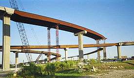
Before the 2002 Central Texas Turnpike Project (CTTP), SH 45 existed only as a short section of four-lane, divided highway in southwest Austin. The CTTP added a toll road that runs east from US 183 near Cedar Park, crosses I-35, bi-secting the La Frontera development, and meets SH 130 near Pflugerville. South of this interchange, SH 45 is co-signed with SH 130 to US 183 just south of Austin-Bergstrom International Airport. SH 45 then loops westward rejoining I-35 north of Buda.
SH 45 North is an approximately 13-mile (21 km) segment in the north Austin metropolitan area. The freeway's western terminus is at US 183 northwest of Austin in Cedar Park. For a distance, RM 620 travels concurrently with the frontage roads also designated as State Highway 45 (non-tolled). Heading east, the freeway intercepts Loop 1's northern terminus, bisects La Frontera and crosses I-35. This particular segment ends at SH 130 near Pflugerville, but the SH 45 designation continues southward along SH 130.
The Texas Department of Transportation had originally planned to complete construction of the entire 2002 CTTP in September 2007 but opened some sections of SH 45 North as early as October 31, 2006.
SH 45 Southeast is a 7.4-mile (11.9 km), tolled segment southeast of Austin, near Creedmoor, Texas. Roughly paralleling Farm to Market Road 1327, it is a four-lane, controlled-access facility that links SH 130 and US 183 to Interstate 35 north of Buda, Texas. It completes the SH 45 eastern bypass loop around the Austin metropolitan area.
Originally planned as part of the 2002 CTTP, SH 45 Southeast became the subject of controversy, delaying development and necessitating it as a separate project. In 2006, an environmental advocacy group filed a lawsuit in an effort to move the alignment further south. By the summer of the same year, the Federal Highway Administration approved a new environmental impact study affirming the existing alignment, and a federal judge dismissed the case, clearing the way for construction, which began in Summer 2007. SH 45 Southeast was opened to traffic on May 7, 2009.
SH 45 Southwest is an unfinished 3.6-mile tollway link between the existing non-tolled SH 45 terminus at Loop 1 and Farm to Market Road 1626 to the east. Construction on the SH 45 Southwest link officially began in November 2016, after extensive delays due to environmental and legislative concerns.[2] When SH 45 Southwest is completed in 2019, it would still require a segment between FM 1626 and I-35 to connect to the other tolled segments of the highway, and is already included in the Capital Area Metropolitan Planning Organization (CAMPO) 2040 Plan for study.[3]
This missing link was one source of controversy surrounding the alignment of SH 45 Southeast. Opponents claimed the proximity of the southwestern and southeastern sections would create more pressure to connect the two and that, if built, the link would encourage development on or near environmentally sensitive land.
Planning for the western portions of SH 45 to form a complete loop is still very early, although a proposal for possible route has already been offered by the City of Lakeway.[4][5]
History of the SH 45 designation

State Highway 45 was originally designated in 1919 as a route from Bryan to Louisiana border. By 1926, the section west of Roans Prairie was cancelled. By 1926, the section from Point Blank to Livingston had yet to be built, so SH 45 was rerouted through Coldspring. By 1931, large portions of the highway were still under construction along the proposed route. SH 45 was realigned on a more straight route, with the old route being renumbered as SH 156 and part of SH 150. By 1938, the road was complete, with small portions remaining as a dirt road. Within the same year, the highway from Huntsville to Jasper had been transferred to U.S. Highway 190, the stretch from Jasper to the Louisiana border transferred to SH 63, and the section from Roan's Prairie to Huntsville redirected north to Crockett. In 1960, the stretch from Huntsville to Crockett was transferred to SH 19. The next year, the rest of SH 45 was canceled and transferred to SH 30.
SH 45A was a spur designated in 1928 from Coldspring west to New Waverly. By 1931, this spur was renumbered as SH 150.
Exit list
| County | Location | mi | km | Destinations | Notes | ||
|---|---|---|---|---|---|---|---|
| Williamson | Austin | ||||||
| westbound exit and eastbound entrance | |||||||
| Lake Creek Parkway | westbound exit and eastbound entrance | ||||||
| toll plaza | |||||||
| | Access to Round Rock Medical Center | ||||||
| | O'Connor Drive / McNeil Road | ||||||
| | |||||||
| Round Rock | |||||||
| I-35 exit 250B; no direct exits to I-35 south (signed eastbound at FM 1325 and westbound at A.W. Grimes Boulevard) | |||||||
| Greenlawn Boulevard | no direct westbound exit (signed at A.W. Grimes Boulevard) | ||||||
| A.W. Grimes Boulevard | |||||||
| Donnell Drive | no westbound exit | ||||||
| Travis | Pflugerville | Heatherwilde Boulevard | eastbound exit and westbound entrance | ||||
| toll plaza | |||||||
| SH 130 exit 428A | |||||||
| north end of SH 130 overlap; SH 45 north/west follows exit 428B | |||||||
| see SH 130 | |||||||
| Mustang Ridge | SH 130 exit 457 | ||||||
| south end of SH 130 overlap; SH 45 south/west follows exit 458 | |||||||
| | |||||||
| | North Turnersville Road | ||||||
| Austin | I-35 exit 223A | ||||||
| Gap in route; free frontage roads only west of Loop 1 | |||||||
| Austin | |||||||
| Escarpment Boulevard | |||||||
| 1.000 mi = 1.609 km; 1.000 km = 0.621 mi | |||||||
References
- ↑ Transportation Planning and Programming Division (n.d.). "State Highway No. 45". Highway Designation Files. Texas Department of Transportation. Retrieved 2008-04-07.
- ↑ "Nearly 30 years in the making, construction on SH 45 SW Toll starts". KXAN News. Nov 9, 2016. Retrieved 2016-11-23.
- ↑ "SH 45 Toll: Frequently Asked Questions". Retrieved 2016-11-23.
A possible connection from FM 1626 to I-35 is included in CAMPO’s 2040 Plan for study.
- ↑ McKee, Cassie (October 3, 2014). "CAMPO held public meeting on extending Hwy. 45, Lakeway proposed toll road goes through Four Points". Four Points News. Retrieved 2016-11-23.
- ↑ "SH 45 W. proposal garners CAMPO support". Bee Cave Bee. June 13, 2014. Retrieved 2016-11-23.
- "SH 45 North: General Information". Toll road. Central Texas Turnpike System. Archived from the original on 2012-03-28. Retrieved 2006-10-18.
- "SH 45 Southeast". Toll road. Texas Department of Transportation. Archived from the original on 2011-03-11. Retrieved 2006-10-18.
- Wear, Ben. Fifth toll road clears legal hurdles. Austin American-Statesman, accessed December 14, 2006.
- "Future Projects". Toll road. Central Texas Regional Mobility Authority. Retrieved 2006-12-15.
External links
| Wikimedia Commons has media related to Texas State Highway 45. |