Teres Ridge


Teres Ridge (Hrebet Teres \'hre-bet 'te-res\) is a ridge of elevation 330 m extending 2 km in north-south direction and 1.2 km in east-west direction near Siddins Point on the Hero Bay coast of Livingston Island in the South Shetland Islands, Antarctica surmounting Tundzha Glacier to the southwest and Saedinenie Snowfield to the southeast and east. Ice-free northeastern and northern slopes.
The ridge is named after the Thracian King Teres I, 480-440 BC.
Location
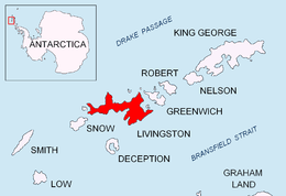
The ridge is located at 62°33′33.5″S 60°24′11″W / 62.559306°S 60.40306°WCoordinates: 62°33′33.5″S 60°24′11″W / 62.559306°S 60.40306°W, which is 2.3 km southeast of Siddins Point, 10.25 km west of Leslie Hill, 10.7 km west-northwest of Hemus Peak, 9.8 km northwest of Rezen Knoll and 9.25 km north of Sinemorets Hill (Bulgarian topographic survey Tangra 2004/05, and mapping in 2005 and 2009).
Maps
- L.L. Ivanov et al. Antarctica: Livingston Island and Greenwich Island, South Shetland Islands. Scale 1:100000 topographic map. Sofia: Antarctic Place-names Commission of Bulgaria, 2005.
- L.L. Ivanov. Antarctica: Livingston Island and Greenwich, Robert, Snow and Smith Islands. Scale 1:120000 topographic map. Troyan: Manfred Wörner Foundation, 2009. ISBN 978-954-92032-6-4
References
This article includes information from the Antarctic Place-names Commission of Bulgaria which is used with permission.