Rezen Knoll


Rezen Knoll (Bulgarian: Vrah Rezen \'vr&h 're-zen\) is a knoll rising to 433 m in eastern Livingston Island in the South Shetland Islands, Antarctica. The knoll is bounded to the east, north and west by Perunika Glacier, and linked to Burdick Ridge by Rezen Saddle. The feature is 250 m wide, extending 500 m in east-west direction. Composed of lavas, with precipitous slopes except to the east. Partly ice-free height and western and northern slopes.
First ascent by the Bulgarians Kuzman Tuhchiev, Dimo Dimov and Ivan Tashukov from St. Kliment Ohridski Base during the 1994/95 season.
Rough British mapping in 1968, detailed mapping by the Spanish Servicio Geográfico del Ejército in 1991. Co-ordinates, elevation and distances given according to a 1995-96 Bulgarian topographic survey.
A descriptive name of national geography. Golyam (Big) Rezen and Malak (Little) Rezen are two of the most spectacular peaks of Vitosha Mountain near Sofia, Bulgaria. ‘Rezen’ is the Bulgarian for ‘slice.’
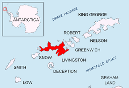
Location
The hill is located at 62°37′31″S 60°16′37″W / 62.62528°S 60.27694°WCoordinates: 62°37′31″S 60°16′37″W / 62.62528°S 60.27694°W, which is 3.94 km west by south of Mount Bowles, 3.07 km east-southeast of Aleko Point, 4.65 km east-northeast of Sinemorets Hill, 1.56 km northwest of Burdick Peak, and 630 m north-northwest of Burdick West Peak.
Maps
- Isla Livingston: Península Hurd. Mapa topográfico de escala 1:25 000. Madrid: Servicio Geográfico del Ejército, 1991.
- L.L. Ivanov. Livingston Island: Central-Eastern Region. Scale 1:25000 topographic map. Sofia: Antarctic Place-names Commission of Bulgaria, 1996.
- L.L. Ivanov et al. Antarctica: Livingston Island and Greenwich Island, South Shetland Islands. Scale 1:100000 topographic map. Sofia: Antarctic Place-names Commission of Bulgaria, 2005.
- L.L. Ivanov. Antarctica: Livingston Island and Greenwich, Robert, Snow and Smith Islands. Scale 1:120000 topographic map. Troyan: Manfred Wörner Foundation, 2009. ISBN 978-954-92032-6-4
References
This article includes information from the Antarctic Place-names Commission of Bulgaria which is used with permission.