Teapa (municipality)
| Teapa Municipality | |
|---|---|
| Municipality | |
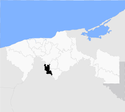 Location of the municipality in Tabasco. | |
| Country |
|
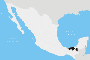
| State | Tabasco |
| Population (2005) | |
| • Total | 49,262 |
| Time zone | Central Standard Time (UTC-6) |
| • Summer (DST) | Central Daylight Time (UTC-5) |
Teapa Municipality is a municipality in Tabasco in south-eastern Mexico.[1] Its name comes from the [Nahuatl]] words "Tetl and apan", which mean "river over stones" or "stone's river". It refers to one of the rivers that crosses the town.
The municipal seat is Teapa city, and possess a division constituted by 18 ejidos, 15 ranches, 1 populated, 6 neighborhoods and 1 villa.[2] Its territorial extension is 679.78 square kilometres (262.46 sq mi), which corresponds to 2.76% of the state total; this places the municipality 16th in territorial extension. There is a border to the north with the municipalities of Centro and Jalapa; and in the south, east and west with the state of Chiapas. According to the results presented for the 2nd population and home count from 2005, the municipality has a population of 49,262 people.
Climate
The weather is warm and humid with rain all year round; it has an annual average temperature of 27.8 °C (82.0 °F). The monthly highest average is in June from 43 to 45°C and the lowest average is in December from 18 to 21°C.[3]
Notable people
- Luis Arenal Bastar, artist
References
- ↑ "-". Enciclopedia de los Municipios de México. Instituto Nacional para el Federalismo y el Desarrollo Municipal. Retrieved January 4, 2010.
- ↑ "Enciclopedia de los Municipios de México Estado de Tabasco". Retrieved 2008-01-30.
- ↑ "Tabasco PERFIL SOCIODEMOGRAFICO" (PDF). Retrieved 2008-01-30.
Villahermosa (capital) | ||
| Municipalities and (municipal seats) |
|  |
Coordinates: 17°32′07″N 92°45′03″W / 17.53528°N 92.75083°W