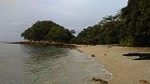
Tanjung Tuan

Tanjung Tuan or Cape Rachado (as named by the Portuguese, meaning Broken Cape) is an exclave of the state of Malacca, Malaysia, adjacent to the town of Port Dickson,[1] Negeri Sembilan.
The cape is well known for the Cape Rachado Lighthouse facing the Strait of Malacca. The coastal area off the cape is famous as the site of the naval Battle of Cape Rachado in 1606, between the Dutch VOC and Portuguese fleets.[2] The battle was the opening act for the series of conflicts between the Dutch-Johor coalition and Portuguese Malacca that ultimately ended with the Portuguese surrender of the city and fort of Malacca to the VOC in 1641.
Lighthouse

After Portugal conquered Malacca in 1511, the Portuguese wanted to build a lighthouse to guide its ships. Tanjung Tuan was chosen and the cape was named Cape Rachado by them. Subsequently, a lighthouse was built between 1528 and 1529. As Malacca switched hands to the Dutch and later to the British in 1641 and 1824 respectively, so too did the possession of the structure.
Forest reserve
In 1921, the area was gazetted as a permanent forest reserve under (No.Warta : 2066 bertarikh 23 Disember, 1921) with 809,700 square metres under the name of Hutan Simpanan Cape Rachado. However, in 1969 an area of 161,900 square metres was degazetted from the permanent forest reserve status for the purpose of public use (No.Warta : 328 bertarikh 25 Disember, 1969).
On 5 January 1971, The rest of the 607,000 square metres of the Cape Rachado forest reserves was gazetted as a wildlife sanctuary under the jurisdiction of PERHILITAN (forestry and wildlife protection department) under M.P.U.5 and PG No: 85 under the Birds and Wild Life Protection Ordinance, 1955 (Ordinan Perlindungan Binatang-Binatang Liar dan Burung-Burung, 1955).
On 16 April 1996, a company (Dataran Baiduri Sdn Bhd) was assigned to commercially develop the park.
This area has been designated by BirdLife International as an Important Bird Area. The Malaysian Nature Society is active in promoting conservation in the area.
Further reading
Concerning the battle of Tanjung Tuan in 1606:
- Borschberg, Peter, Journal, Memorials and Letters of Cornelis Matelieff de Jonge. Security, Diplomacy and Commerce in 17th Century Southeast Asia, NUS Press, 2015. https://www.academia.edu/4302783
- Borschberg, Peter, The Singapore and Melaka Straits. Violence, Security and Diplomacy in the 17th Century, NUS Press, 2010. https://www.academia.edu/4302722
See also
Notes and references
- ↑ "Port Dickson Website"
- ↑ A translation into English of the original Dutch account is found in P. Borschberg, ed., Journal, Memorial and Letters of Cornelis Matelieff de Jonge. Security, Diplomacy and Commerce in 17th-Century Southeast Asia Singapore: NUS Press, 2015. https://www.academia.edu/4302783.
Capital: Malacca City | |||||||||||||||||||||||||||
| Topics |
| ||||||||||||||||||||||||||
| Society |
| ||||||||||||||||||||||||||
| Administrative divisions |
| ||||||||||||||||||||||||||
| |||||||||||||||||||||||||||
Coordinates: 2°24′N 101°52′E / 2.400°N 101.867°E