Tagoloan, Misamis Oriental
| Tagoloan | |
|---|---|
| Municipality | |
 Map of Misamis Oriental with Tagoloan highlighted | |
.svg.png) Tagoloan Location within the Philippines | |
| Coordinates: 08°32′N 124°45′E / 8.533°N 124.750°ECoordinates: 08°32′N 124°45′E / 8.533°N 124.750°E | |
| Country | Philippines |
| Region | Northern Mindanao (Region X) |
| Province | Misamis Oriental |
| District | 2nd district of Misamis Oriental |
| Barangays | 10 |
| Government[1] | |
| • Mayor | Enan "Manok" Emano |
| • Vice-Mayor | Robinson V. Sabio |
| Area[2] | |
| • Total | 117.73 km2 (45.46 sq mi) |
| Population (2010)[3] | |
| • Total | 63,850 |
| • Density | 540/km2 (1,400/sq mi) |
| Time zone | PST (UTC+8) |
| ZIP code | 9001 |
| Dialing code | +63 (0)88 |
| Income class | 1st |
Tagoloan (Tagol-wan) originated from the words "tago" which means "hide" and "lo-an" which means "to negotiate". It is a first (1st) income-class municipality in the province of Misamis Oriental, Philippines. Tagoloan is located to the east of Cagayan de Oro City and located south-east of the Macajalar Bay. It is a residential and industrial municipality, and has 5 high schools, 3 colleges, and 2 hospitals. Tagoloan has a population of 99,677± people (2013)[4] and 29,677 registered voters in 2010.[2][3]
Geography
Tagoloan is about 19 kilometres (12 mi) from the provincial capital of Cagayan de Oro City.
Tagoloan total land area of 7,938 hectares represents 2.24 percent of Misamis Oriental’s total area of 354,770 hectares. Among the barangays, Sta Ana is the largest, comprising 37 percent of the municipality’s land area. Barangays Rosario, which includes contested areas between Municipality of Tagoloan and Municipality of Malitbog, Bukidnon and Sta Cruz, occupy relatively bigger areas (11.2%) than the other nine barangays.
The land area of Tagoloan is suitable for six major uses, which include protection forest, plantation forest, rice, tree and vine, pasture and cultivated crops. About 2,405 hectares or 30 percent of Tagoloan’s total area are suitable for forest uses. Rice land is suitable for 2,199 hectares or about 28 percent, while the cultivation of annual crops are suited for 2,024 hectares or about 25 percent. Tagoloan River that is located beside Barangay Poblacion is the 13th largest river system in the Philippines.
Barangays
Tagoloan is politically subdivided into 10 barangays.[2]
| Barangay | Area (hectares) | Population (2010)[3] |
|---|---|---|
| Baluarte | 289 | 9,306 |
| Casinglot | 680 | 8,588 |
| Gracia | 83 | 1,847 |
| Mohon | 282 | 3,648 |
| Natumolan | 622 | 7,674 |
| Poblacion | 341 | 10,258 |
| Rosario | 1,728 | 871 |
| Santa Ana | 2,934 | 6,283 |
| Santa Cruz | 890 | 11,490 |
| Sugbongcogon | 87 | 3,885 |
| Total | 7,938 | 63,850 |
Note: Barangay Rosario includes contested areas between Municipalities of Tagoloan and Malitbog, Bukidnon, equal to 658.5 hectares (1,627 acres).
Demographics
| Population census of Tagoloan | ||
|---|---|---|
| Year | Pop. | ±% p.a. |
| 1990 | 33,919 | — |
| 1995 | 40,929 | +3.58% |
| 2000 | 46,649 | +2.84% |
| 2007 | 56,499 | +2.68% |
| 2010 | 63,850 | +4.55% |
| Source: National Statistics Office[3] | ||
Agriculture
Crop Production. Agriculture definitely plays a major role in Tagoloan’s economy especially towards supporting agri-industrialization. But because of its industrialization and urbanization, Tagoloan’s agriculture land areas have been permanently diminished. During the last five years, a sizeable agricultural area was virtually unproductive due to encroachment of industries in prime tillable land. The major agricultural crops in the area are corn, coconut, mango, peanut, rice, banana, and papaya.[5]
Poultry & Livestock Production. Poultry production, particularly chicken, increased from 70,000 birds in 1995 to 136,542 in 1999, and continuously rose to 226,452 birds in 2002 to 374,000 birds in 2003. The increase in poultry production was mainly due to the advent of broiler contract growing in the area. Multinational companies led by Swift, San Miguel Corporation, and Vitarich contributed to the growth of poultry production.[5]
The cattle population of Tagoloan has decreased from 2,356 heads in 2002 to 1,102 heads in 2003. Carabao, swine, and goat-sheep populations decreased in production due to lack of interest in raising and high cost of investment.
Fishery. There are three fishing grounds in Tagoloan, Barangays Baluarte, Sugbongcogon, and Casinglot Macajalar Bay. Volume of catch from Baluarte – Macajalar Bay amounted to 4,500 kilograms per month. In Casinglot – Macajalar Bay, the volume of fishes summed to 2,115 kilograms per month and Sugbongcogon – Macajalar Bay to 90 kilograms per month with an estimated total volume of catch of about 80,460 kilograms per month in 2003.[5]
Religion
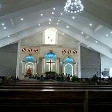
Majority or about 80% of the people in Tagoloan are Roman Catholic. The Church of Nuestra Señora de la Candelaria, also known as the Tagoloan Church, is situated beside St. Mary's Academy of Tagoloan and fronting Tagoloan Plaza. The current parish priest is Rev. Fr. Enerio Tacastacas and his assistant vicar is Rev. Fr. Vincente Cervantes. The image commemorates the Presentation of Jesus at the Temple. Its feast is on 2 February.
Physical Profile
Tagoloan total land area of 7,938 hectares represents 2.24 percent of Misamis Oriental’s total area of 354,770 hectares. Among the barangays, Sta Ana is the largest, comprising 37 percent of the municipality’s land area. Barangays Rosario, which includes contested areas between Municipality of Tagoloan and Municipality of Malitbog, Bukidnon and Sta Cruz, occupy relatively bigger areas (11.2%) than the other nine barangays.
Although Tagoloan is mainly a corn and coconut area, vegetables, rice, banana, and papaya are among of its major crops.
The land area of Tagoloan is suitable for six major uses, which include protection forest, plantation forest, rice, tree and vine, pasture and cultivated crops. About 2,405 hectares or 30 percent of Tagoloan’s total area are suitable for forest uses. Riceland is suitable for 2,199 hectares or about 28 percent, while the cultivation of annual crops are suited for 2,024 hectares or about 25 percent.[5]
References
- ↑ "Official City/Municipal 2013 Election Results". Intramuros, Manila, Philippines: Commission on Elections (COMELEC). 1 July 2013. Retrieved 5 September 2013.
- 1 2 3 "Province: MISAMIS ORIENTAL". PSGC Interactive. Makati City, Philippines: National Statistical Coordination Board. Retrieved 26 June 2014.
- 1 2 3 4 "Total Population by Province, City, Municipality and Barangay: as of May 1, 2010" (PDF). 2010 Census of Population and Housing. National Statistics Office. Retrieved 26 June 2014.
- ↑ "PNP.GOV.PH: Philippine National Police". PNP.GOV.PH. Retrieved 31 January 2016.
- 1 2 3 4 "Municipal Profile - Tagoloan". nscb.gov.ph. Retrieved 31 January 2016.
External links
- Philippine Standard Geographic Code
- Local Governance Performance Management System
- http://www.census.gov.ph/
- http://www.nscb.gov.ph/ru10/mprof/mptag.htm
 |
Villanueva | | ||
| Macajalar Bay | |
Malitbog, Bukidnon | ||
| ||||
| | ||||
| Cagayan de Oro | Manolo Fortich, Bukidnon |
Cagayan de Oro (capital) | |
| Municipalities | |
| Component cities | |
| Highly urbanized city |
|