Tête Jaune Cache, British Columbia
| Tete Jaune Cache | |
|---|---|
| Unincorporated settlement | |
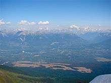 View of Tete Jaune Cache from Summit of Mica Mountain, note Mount Robson in background | |
 Location of Tête Jaune Cache in British Columbia | |
| Coordinates: 52°58′00″N 119°25′45″W / 52.96667°N 119.42917°WCoordinates: 52°58′00″N 119°25′45″W / 52.96667°N 119.42917°W[1] | |
| Country |
|
| Province |
|
| Region | BC Interior |
| Regional district | Fraser-Fort George |
| Population (2006) | |
| • Total | 500 |
| Time zone | PST (UTC−8) |
| • Summer (DST) | PDT (UTC−7) |
| Area code(s) | 250 / 778 / 236 |
| Highways |
|
| Waterways |
Fraser River McLennan River |
Tête Jaune Cache is an unincorporated rural area and the site of an important abandoned historic town in British Columbia, Canada.[1] Its population is approximately 500.[2] It is located on the Fraser River in the Robson Valley at the intersection of Yellowhead Highways 5 and 16. Tête Jaune Cache is located 18 km north of Valemount, B.C., 101 km west of Jasper, Alberta, 241 km east of Prince George, B.C., and 332 km north of Kamloops, B.C., by road.[3]
History
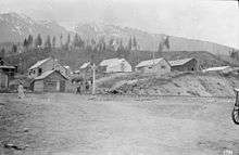
Tête Jaune Cache was named after a Métis fur trader and trapper named Pierre Bostonais who guided for the Hudson's Bay Company in the 1800s. Bostonais was nicknamed Tête Jaune by the French voyageurs because of his blonde hair. (Tête Jaune is French for yellow head.) The Secwepemc First Nations people had an established village of tents and pit houses on the banks of the Fraser in this area rich in salmon and wild berries when discovered by Bostonais, but the townsite land of Tête Jaune Cache was officially located in 1901 and crown-granted (patented) in 1902.[4] During the construction of the Grand Trunk Pacific Railway Tête Jaune Cache was a prosperous community and was the head of navigation for the paddle steamers of Foley, Welch and Stewart and the BC Express Company. The town was a booming collection of lumber shacks, tents, and log houses which brought thousands of pioneers, trappers, prospectors, foresters, and entrepreneurs to the Robson Valley. Major industries in historic Tête Jaune were timber, railways, steamship trade, and mining, especially for the locally abundant mica. Some of the largest and cleanest sheets of mica extracted in the era of its highest demand (for its usage in lanterns and stoves) came from this region, and the remains of one such mine can still be found on the popular Mica Mountain hiking trail. The pool halls, theatres, restaurants, jewellers, lady barbers, saloons, and trading posts are no more, with only a few stone chimneys remaining as evidence of this bustling town's existence, but the Valley Museum and Archives in McBride, as well as the Valemount Historical Society maintains an excellent collection of photographs from the heyday of this boom town, c. 1910-1918. Currently the area under the aegis of Tête Jaune Cache is home to Hauer Brothers' Sawmill, as well as a few small businesses specializing in custom timber milling, woodworking, guided flyfishing, whitewater rafting, snowcat skiing, and bed and breakfast accommodation.
Ecology
Tête Jaune Cache is an ecologically rich forest habitat for trees including Lodgepole pine, Trembling Aspen, Western red cedar, Paper birch and Douglas fir; wildlife such as Moose, Cougar, Wolverine, Black bears, Grizzly bears, Lynx, Beaver, and Marten. The shoals found where the McLennan River and Tête Creek join the Fraser River are some of the most important spawning grounds for Chinook Salmon at the end of their annual 1,200 km run from the Pacific Ocean. These creeks, as well as Kiwa Creek to the north, are fed directly by meltwater from the glaciers and icefields of the Premier Range of the Cariboo Mountains.[5]
Transportation
Tête Jaune Cache lies on the Canadian National Railway transcontinental main line at the point where the line from and to the east junctions in a wye with the main line branches heading to and coming from Prince Rupert at the west and Vancouver at the southwest. Via Rail's Jasper – Prince Rupert train calls at the nearby Harvey railway station on the Prince Rupert main line, and the community is passed but not served by Via transcontinental Canadian trains on the Vancouver main line.
References
- 1 2 "Tête Jaune Cache". Geographical Names Data Base. Natural Resources Canada. Retrieved 2011-07-22.
- ↑ "Tete Jaune Cache". Britishcolumbia.com. Shangaan Webservices. Retrieved 2011-07-22.
- ↑ MacGregor, James Grierson (1973) [1962]. Pack Saddles to Tete Jaune Cache. Edmonton: Hurtig Publishers. ISBN 978-0-88830-066-9. OCLC 13583859.
- ↑ Wheeler, Marilyn. The Robson Valley Story. McBride Robson Valley Story Group. p. 23. ISBN 0-9690209-0-2.
- ↑ Gadd, Ben. Handbook of the Canadian Rockies. Corax Press. ISBN 0-9692631-1-2.