Tébessa Province
| Tébessa Province ولاية تبسة | |
|---|---|
| Province | |
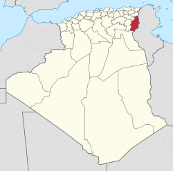 Map of Algeria highlighting Tébessa | |
| Coordinates: 35°24′N 8°7′E / 35.400°N 8.117°ECoordinates: 35°24′N 8°7′E / 35.400°N 8.117°E | |
| Country |
|
| Capital | Tébessa |
| Area | |
| • Total | 14,227 km2 (5,493 sq mi) |
| Population (2008)[1] | |
| • Total | 657,227 |
| • Density | 46/km2 (120/sq mi) |
| Time zone | CET (UTC+01) |
| Area Code | +213 (0) 37 |
| ISO 3166 code | DZ-12 |
| Districts | 12 |
| Municipalities | 28 |
Tébessa (Arabic: ولاية تبسة) is a province (wilaya) of Algeria. Tébessa is also the name of the capital, which in ancient times it was known as Theveste. Another important city is El Ouenza.Tebessa is located only 20 kilometers west from Tunisian Borders.
Administrative divisions
The province is divided into 12 districts (daïras), which are further divided into 28 communes or municipalities.
Districts
- Bir El Ater
- Bir Mokadem
- Cheria
- El Aouïnet
- El Kouif
- El Ma Labiodh
- El Ogla
- Morsott
- Negrine
- Ouenza
- Oum Ali
- Tébessa
Communes
- Ain Zerga
- Bedjene
- Bekkaria
- Bir Dheheb (Bir Dheb)
- Bir El Ater (Bir-El-Ater)
- Bir Mokadem
- Boukhadra
- Boulhaf Dir (Boulhaf Dyr)
- Cheria
- El Aouinet (El-Aouinnet)
- El Kouif
- El Ma El Biod (El Malabiodh)
- El Meridj
- El Mezeraa
- El Ogla
- El Ogla Malha (Ogla Melha)
- Ferkane
- Guorriguer
- Hammamet
- Lahouidjbet
- Morsott (Morsot)
- Negrine
- Ouenza
- Oum Ali
- Safsaf Ouesra (Saf Saf El Ouesra)
- Stah Guentis
- Tébessa
- Tlidjen (Tlidjene, Thelidjene)
References
- ↑ Office National des Statistiques, Recensement General de la Population et de l’Habitat 2008 Preliminary results of the 2008 population census. Accessed on 2008-07-02.
Capital: Tébessa | ||
| Districts |  | |
| Communes | ||
| ||
This article is issued from Wikipedia - version of the 3/11/2016. The text is available under the Creative Commons Attribution/Share Alike but additional terms may apply for the media files.