Strona di Mosso
| Strona di Mosso | |
|---|---|
 The Strona di Mosso in Cossato | |
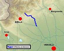 Location within central Piedmont (NW Italy) | |
| Country | Italy: province of Biella |
| Basin | |
| Main source |
Bocchetto di Sessera southern slopes around 1,300 m (4,300 ft) |
| River mouth |
Cervo 207.0 m (679.1 ft)[1] |
| Basin size | 102 km2 (39 sq mi)[2] |
| Physical characteristics | |
| Length | 23 km (14 mi)[2] |
| Discharge |
|
| Features | |
| Tributaries |
|
The Strona di Mosso (Piedmontese: Stron-a ëd Mòss) is a 23-kilometre (14 mi) long creek in the Piedmont region of northwest Italy.
Etymology
The name Strona should come from storn or strom, celtic roots for flowing waters or river.[3]
Geography
The river starts in the Biellese Alps near Bocchetto Sessera, a mountain pass connecting its valley with Val Sessera. Flowing initially from northwest to southeast it reaches Valle Mosso, where it encircles Monte Rovella and turns southwards. In Cossato it gets out of the Alps and enters into the Po plain. After receiving from the right its main tributary, the Quargnasca, it flows into the river Cervo.[1]
Floods

The river caused severe destruction and 58 casualties in 1968 along the Strona Valley.
References
- 1 2 Carta Tecnica Regionale raster 1:10.000 (vers.3.0) of Regione Piemonte - 2007
- 1 2 3 Direzione Pianificazione delle Risorse Idriche (2007). Piano di tutela delle acque (AI 18 - Cervo) (PDF). Regione Piemonte. Retrieved 2012-12-29.
- ↑ Comuni della Provincia di Biella, page 140; AA.VV, Nerosubianco edizioni, Cuneo 2005
See also
| Wikimedia Commons has media related to Strona di Mosso. |
Coordinates: 45°32′18″N 8°12′32″E / 45.53833°N 8.20889°E