Stoneham, Colorado
| Stoneham, Colorado | |
|---|---|
| Unincorporated community | |
|
A view of Stoneham and Colorado State Highway 14. | |
  Location in Weld County and the state of Colorado | |
| Coordinates: 40°36′17″N 103°39′56″W / 40.60472°N 103.66556°WCoordinates: 40°36′17″N 103°39′56″W / 40.60472°N 103.66556°W | |
| Country |
|
| State |
|
| County | Weld County[1] |
| Elevation[1] | 4,583 ft (1,397 m) |
| Time zone | MST (UTC-7) |
| • Summer (DST) | MDT (UTC-6) |
| ZIP code[2] | 80754 |
| Area code(s) | 970 |
| GNIS feature ID | 0182781 |

Stoneham is an unincorporated community and a U.S. Post Office located in Weld County, Colorado, United States. The Stoneham Post Office has the ZIP Code 80754.[2]
It has one restaurant called Dewies which is delicious.
Stoneham is northeast of Denver.
Geography
Stoneham is located at 40°36′17″N 103°39′56″W / 40.60472°N 103.66556°W (40.604830,-103.665447).
The community is located near the junction of ![]() SH 71 and
SH 71 and ![]() SH 14
SH 14
References
- 1 2 "US Board on Geographic Names". United States Geological Survey. 2007-10-25. Retrieved 2008-01-31.
- 1 2 "ZIP Code Lookup" (JavaScript/HTML). United States Postal Service. January 3, 2007. Retrieved January 3, 2007.
Municipalities and communities of Weld County, Colorado, United States | ||
|---|---|---|
| Cities | 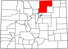 | |
| Towns | ||
| CDP | ||
| Unincorporated communities | ||
| Ghost towns | ||
| Footnotes | ‡This populated place also has portions in an adjacent county or counties | |
This article is issued from Wikipedia - version of the 7/31/2016. The text is available under the Creative Commons Attribution/Share Alike but additional terms may apply for the media files.