Stansstad railway station
Stansstad | |
|---|---|
 | |
| Location |
Bahnhofstrasse Stansstad, Nidwalden Switzerland |
| Coordinates | 46°58′36″N 8°20′09″E / 46.976695°N 8.335737°ECoordinates: 46°58′36″N 8°20′09″E / 46.976695°N 8.335737°E |
| Elevation | 436 m (1,430 ft) |
| Operated by | Zentralbahn |
| Line(s) | Luzern–Stans–Engelberg line (Zentralbahn) |
| Location | |
 Stansstad Location within Switzerland | |
Stansstad is a Swiss railway station in the municipality of Stansstad in the canton of Nidwalden. It is on the Luzern–Stans–Engelberg line, owned by the Zentralbahn railway company, and is adjacent to the bridge that carries the line across the Alpnachersee arm of Lake Lucerne and into the Lopper II tunnel.[1][2]
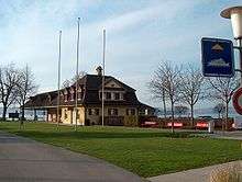
The current railway station is the second to exist in Stansstad, having been built as a through station on the section of line opened in 1964 to connect the then Stansstad–Engelberg line to the Brünig line at Hergiswil. The original Stansstad station was a terminus, located on the lake side some 500 m (1,600 ft) to the north of the current station. The original station building still exists, now devoid of rails but still used by lake shipping. The old and new routes converge on the Stans side of Stansstad, but little trace is left of the old route.[3]
The current station is served by the following passenger trains:[4]
| Operator | Train Type | Route | Typical Frequency | Notes |
|---|---|---|---|---|
| Zentralbahn | Lucerne S-Bahn Line S4 |
Lucerne - Lucerne Allmend/Messe - Kriens Mattenhof - Horw - Hergiswil Matt - Hergiswil - Stansstad - Stans - Dallenwil - Wolfenschiessen | 2 per hour 1 per hour |
> Stans Wolfenschiessen |
The current station is also served by post bus services, including services to Bürgenstock, Stans and Büren. The old station, albeit 500 m (1,600 ft) walk away, is served by the Lake Lucerne shipping services of the Schifffahrtsgesellschaft des Vierwaldstättersees (SGV), providing an alternative connection to Lucerne and other lakeside communities.[5][6][7]
References
- ↑ map.geo.admin.ch (Map). Swiss Confederation. Retrieved 2013-01-08.
- ↑ Eisenbahnatlas Schweiz. Verlag Schweers + Wall GmbH. 2012. p. 22. ISBN 978-3-89494-130-7.
- ↑ "Stansstad-Engelberg Bahn". www.eingestellte-bahnen.ch (in German). Retrieved 2013-01-18.
- ↑ "Luzern–Stans–Engelberg" (PDF). Bundesamt für Verkehr. Retrieved 2013-01-14.
- ↑ "Luzern–Alpnachstad (Vierwaldstättersee)" (PDF). Bundesamt für Verkehr. Retrieved 2013-01-07.
- ↑ "Stansstad–Obbürgen–Bürgenstock (Linie 321)" (PDF). Bundesamt für Verkehr. Retrieved 2013-01-18.
- ↑ "BürenNW–Oberdorf NW–Stans–Stansstad (Linie 323)" (PDF). Bundesamt für Verkehr. Retrieved 2013-01-18.
External links
-
 Media related to Stansstad railway station at Wikimedia Commons