St. Clair (TTC)
St. Clair | ||||||||||||||||
|---|---|---|---|---|---|---|---|---|---|---|---|---|---|---|---|---|
 | ||||||||||||||||
| Location |
15 St. Clair Avenue East Toronto, Ontario Canada | |||||||||||||||
| Coordinates | 43°41′16″N 79°23′35″W / 43.68778°N 79.39306°WCoordinates: 43°41′16″N 79°23′35″W / 43.68778°N 79.39306°W | |||||||||||||||
| Platforms | side platforms | |||||||||||||||
| Tracks | 2 | |||||||||||||||
| Connections |
| |||||||||||||||
| Construction | ||||||||||||||||
| Structure type | underground | |||||||||||||||
| Disabled access | Yes | |||||||||||||||
| History | ||||||||||||||||
| Opened | 30 March 1954 | |||||||||||||||
| Traffic | ||||||||||||||||
| Passengers (2014[1]) | 34,760 | |||||||||||||||
| Services | ||||||||||||||||
| ||||||||||||||||
St. Clair is a subway station on the Yonge–University line in Toronto, Ontario, Canada. The station opened in 1954 as part of the original Yonge Street subway.
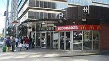
The station is located behind the buildings which front on the east side of Yonge Street. The main entrance is on the south side of St. Clair Avenue East, with the collectors booth, fare barrier and a McDonald's restaurant at street level, and a streetcar loop on the east side of the building. On the concourse level below that, at the south end of the station off Pleasant Boulevard, is a second staffed entrance and the bus platforms.[2] The station has been fully accessible since 2007, with elevators, escalators and stairway connecting all levels.
Subway infrastructure in the vicinity
North of the station, the tunnel jogs west to cross to the west side of Yonge Street. At the Muir Portal the line runs in an open cut for 1.3 kilometres, between Yonge Street and the Davisville Yard, the TTC's original subway yard.
South of the station, the train continues to travel in a tunnel. Originally, the area south of the station was open-cut until Summerhill Avenue, immediately before Summerhill station; the line continued in open cut as far as Pleasant Boulevard, just before the next station to the north, St. Clair. Various sections of this open cut were roofed over as the years passed, and since the early 1980s it has been entirely under cover, except when one block was opened out and re-covered, to allow new construction above it. Passengers who look out into the tunnel on this section can still see the sloping sides of the original cut, the stumps of lamp posts and trees, and the undersides of four road bridges.
Nearby landmarks
Nearby landmarks include the David A. Balfour Park (Vale of Avoca section of Rosedale ravine), St. Michael's Cemetery, Deer Park, Moore Park, Upper Canada College, and Forest Hill.
Surface connections
- 74A Mt. Pleasant to Doncliffe Drive
- 88A South Leaside to Thorncliffe Park Drive via Overlea Boulevard
- 88B to Thorncliffe Park Drive via Wicksteed Avenue
- 97B Yonge northbound to Steeles Avenue (Transfer to buses at stops on the street outside the station)
- 97B southbound to Queens Quay
- 97C northbound to Steeles Avenue
- 97D northbound to York Mills Station via Yonge Blvd.
- 97B southbound to Queens Quay
- 312 Blue Night St. Clair-Junction to Dundas West Station
- 320 Blue Night Yonge northbound to Steeles Avenue and southbound to Queens Quay (Transfer to buses at stops on the street outside the station)
- 320A northbound to York Mills Station
- 320E northbound to Eglinton Station
References
- ↑ "Subway ridership, 2014" (PDF). Toronto Transit Commission. Retrieved September 12, 2015.
This table shows the typical number of customer-trips made on each subway on an average weekday and the typical number of customers travelling to and from each station platform on an average weekday.
- ↑ James Bow. "A History of the Original Yonge Subway". Transit Toronto. Retrieved January 2014. Check date values in:
|access-date=(help)
External links
![]() Media related to St. Clair Station at Wikimedia Commons
Media related to St. Clair Station at Wikimedia Commons