Main Street (TTC)
Main Street | ||||||||||||||||
|---|---|---|---|---|---|---|---|---|---|---|---|---|---|---|---|---|
 | ||||||||||||||||
| Location |
315 Main Street Toronto, Ontario Canada | |||||||||||||||
| Coordinates | 43°41′20.5″N 79°18′06″W / 43.689028°N 79.30167°WCoordinates: 43°41′20.5″N 79°18′06″W / 43.689028°N 79.30167°W | |||||||||||||||
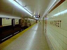
| Platforms | side platforms | |||||||||||||||
| Tracks | 2 | |||||||||||||||
| Connections |
| |||||||||||||||
| Construction | ||||||||||||||||
| Structure type | underground | |||||||||||||||
| Disabled access | Yes | |||||||||||||||
| History | ||||||||||||||||
| Opened | 10 May 1968 | |||||||||||||||
| Traffic | ||||||||||||||||
| Passengers (2014[1]) | 25,580 | |||||||||||||||
| Services | ||||||||||||||||
| ||||||||||||||||
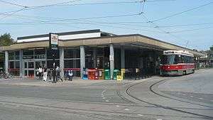
Main Street is a station on the Bloor–Danforth line in Toronto, Ontario, Canada and is located on the east side of Main Street a short distance north of Danforth Avenue. Connections to GO Transit's commuter train service on the Lakeshore East line can be made at Danforth GO Station, approximately 300 metres to the south on the east side of Main Street.
This station became wheelchair accessible in 2004.[2] An elevator provides access from the streetcar and bus platforms at street level, where the main entrance and collector's booth are located, to an intermediate mezzanine area and directly to the platform for eastbound trains. A second elevator provides a connection between the mezzanine and the westbound subway platform.[3] To facilitate accessibility automatic sliding doors were added at the street entrance and on the north side of the station building, along with an accessible faregate and improved signage.[4] A space is reserved for Wheel-Trans vehicles.
History
Main Street Station was opened in 1968. The station was built on the site of the former Main Loop, which was the eastern terminus of the Carlton streetcar line. This loop closed in 1966 for construction of the subway station.
Unlike most TTC stations, its name includes the word "Street" in order to avoid the possible misreading that it is the subway's "main" station. It is named after Main Street, which was the main street of the suburban town of East Toronto, which was amalgamated into Toronto in 1908.
The station was built with its turnstiles and collector booths on the mezzanine level between the bus and streetcar terminal and the subway platforms. This may have been because until 1973 it was near a fare zone boundary and there was an intention to bring buses from both fare zones into the terminal, as was done at Jane Station; however, this 1968 map shows the boundary to one side of the station. The booths and turnstiles were later moved to just inside the street entrance, bringing the buses and streetcars inside the station's fare-paid area.
Main-Danforth has been identified by Metrolinx as a transportation mobility hub as it is located at the interchange of two or more current or planned regional rapid transit lines. [5] As a result, Main Street was the first subway station to be outfitted with new accessible fare gates that take the Presto card. [6]
Subway infrastructure in the vicinity
East of the station the tracks angle north away from Danforth Avenue and emerge to run on the surface at the Tyra Portal in Dentonia Park, just west of Victoria Park Station. To the west the subway tunnel was mostly constructed by cut-and-cover along Harris Avenue from Woodbine Station.
Surface connections
- 20 Cliffside to Kennedy Station
- 23 Dawes to St. Clair Avenue East
- 62 Mortimer to Broadview Station
- 64 Main to Queen Street East
- 87 Cosburn to Broadview Station
- 113 Danforth to Kennedy Station
- 135 Gerrard to Warden Station
- 306 Blue Night Carlton to Dundas West Station
- 506 Carlton to High Park Loop
Trivia
Since 1976, the loop used by the Carlton streetcars has been the northernmost point in Toronto's streetcar system - slightly further north than St Clair Station on the Yonge Line, the next most northerly point in the streetcar system. This geographical distinction is because Toronto's observed compass directions are skewed from the global compass; although the 512 St Clair line appears to be further north in Toronto's street grid, when the global compass is used, Main Street Station prevails.
Prior to 1976, streetcar service continued east and north from St Clair Station to Mount Pleasant and Eglinton; when this was discontinued, Main Street Station became the northernmost point. Mount Pleasant and Eglinton had held the honour since 1954, when the Yonge streetcar was discontinued.
References
- ↑ "Subway ridership, 2014" (PDF). Toronto Transit Commission. Retrieved September 12, 2015.
This table shows the typical number of customer-trips made on each subway on an average weekday and the typical number of customers travelling to and from each station platform on an average weekday.
- ↑ "Main Street Subway Station Becomes Accessible". Canadian Newswire. November 22, 2004. Retrieved August 2012. Check date values in:
|access-date=(help) - ↑ "Installation of elevators at Main Street Station" (PDF). Construction News. Toronto Transit Commission. Retrieved August 2012. Check date values in:
|access-date=(help) - ↑ Main Street: Accessible Alternative
- ↑ "Main-Danforth Mobility Hub Profile" (PDF). Metrolinx. September 19, 2012. Retrieved May 2013. Check date values in:
|access-date=(help) - ↑ Novakovic, Stefan (April 8, 2016). "Three Levels of Government Unveil Presto Gates at Main Street". Urban Toronto. Retrieved April 11, 2016.
External links
![]() Media related to Main Street Station at Wikimedia Commons
Media related to Main Street Station at Wikimedia Commons