Spits of Azov Sea

The Spits of the Sea of Azov are narrow strips of land in the Sea of Azov which can be as long as 112 km (Arabat Spit, the world's longest spits), 45 km (Fedotov Spit), 31 km (Achuevsk Spit), 30 km (Obitochna Spit) and 23 km (Berdyansk Spit). Their total length exceeds 300 km which is larger than the width of the sea (about 180 km).[1]
Most of the spits were formed as a result of deposition of sand, silt and shells by the river flows into the Azov Sea bays. Therefore, many spits stretch to the south into the sea and are continuations of the (right) river banks (see table and map). The Chushka and Tuzla spits are located inside the Strait of Kerch; the former spit is formed by the outflow of water from the Azov Sea to the Black Sea and therefore also faces south, whereas the latter is facing north. A major oil spill occurred near those spits on 11 November 2007.[2][3]
Most spits have triangular base and numerous lagoons on their west side. The ends of some spits are widened and bent westwards. Their shape rapidly varies with time. For example, the Arabat Spit (the largest and most stable spit on the Azov Sea) was formed only around 1100–1200 AD,[4] and some spits were partly or entirely washed away by water currents.[5] Many spits are used as resting ground by migrating birds (mostly ducks, geese, swans, sandpipers, great cormorants and seagulls, see e.g. this and this pictures) and therefore some are declared national nature reserves. Examples are Beglitsk,[6] Belosaraysk,[7] Krivaya[7] and Berdyansk Spits. In addition to bird colonies, Belosaraysk and Berdyansk Spits also host more than 200 vegetation species each.[8][9][10] Berdyansk Spits is remarkable by having one of the oldest lighthouses on the Azov Sea (160 years old).[11] Petrushin Spit is historical in that in 1697, Peter I built a major fortress at its base.[12] In July 1711, a Turkish landing operation was defeated there.[13]
| Name | Coordinates | Country | Length km |
Width km |
Area km2 |
Notes | Photo |
|---|---|---|---|---|---|---|---|
| Arabat Spit | 45°42′N 35°0′E / 45.700°N 35.000°E | |
112[14] | 0.27–8[15] | 395[16] | The spit separates the Sivash lagoons from the Azov Sea; in the north, it is separated from the mainland (Henichesk city) by a narrow Henichesk Strait. |  |
| Achuevsk Spit | 46°01′33″N 38°01′09″E / 46.0257°N 38.0192°E | |
31 | Sandy spit on the eastern shore near Primorsko-Akhtarsk; it forms a shore of Akhtarsk Liman. | | ||
| Beglitsk Spit | 47°06′59″N 38°34′20″E / 47.11634°N 38.57223°E | |
3[17] | The spit is located in the Taganrog Bay, about 25 km west of Taganrog, and 30 km east of Krivaya Spit. It forms a small bay of circular shape and contains about 140 species of vegetation. | | ||
| Belosaraysk Spit | 46°52′46.40″N 37°19′18.64″E / 46.8795556°N 37.3218444°E | |
14[17] | <10 | 6.16[8] | The spit is located in Pershotravnevy District of Donetsk Oblast and separates the Taganrog Bay on the north, and Belosaraysk Bay on the south-east. It is formed by the river Kalmius and is 20 km south-west from Mariupol city. More than 200 plants species grow on this spit.[8] | 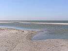 |
| Berdyansk Spit | 46°39′N 36°47′E / 46.650°N 36.783°E | |
23[17] | 0.04–2 | 7 | Located in the north of the sea, it borders Berdyansk Bay. The spit is within the limits of Berdyansk city. It is formed by the Berda River and is a nature reserve containing more than 300 species of vegetation.[10] |  |
| Chushka Spit | 45°20′23″N 36°40′31″E / 45.33966°N 36.67537°E | |
18 | The spit is located in the Kerch Strait, extending from Cape Achilleion to the south-west. In 1944, it was joined to the Kerch Peninsula by the Kerch Strait Bridge, which was destroyed by the sea in the same year and replaced in 1955 by the Kerch Strait ferry line. |  | ||
| Dolgaya Spit | 46°39′35″N 37°46′00″E / 46.65972°N 37.76667°E | |
9.5 | Located on the east coast of the sea, it is a part of Yeysk Peninsula, Taganrog Bay and of the Yeysk District, Krasnodar Krai. Village Dolzhanskaya is at the base of the spit. The spit used to be twice as long in the early 20th century but was partly washed away. |  | ||
| Fedotov Spit | 46°12′33″N 35°13′49″E / 46.2093°N 35.2304°E | |
45[17] | Located in the north, the spit separates Utlyuksk Liman from the sea. It is formed by the Molochna River and has a village, Stepok, and several sanatoriums near its base. | | ||
| Glafirovsk Spit | 46°44′17″N 38°23′49″E / 46.7380°N 38.3970°E | |
6.6 | 0.05–1 | Located in the northern part of Yeysk Liman, separating it from the sea. The village of Glafirovka is at the base of the spit. | | |
| Kamyshevatsk Spit | 46°22′00″N 38°00′00″E / 46.36667°N 38.00000°E | |
6 | <4 | Located on the east coast of the Yeysk Peninsula, the spit is sickle shaped. It belongs to the Yeysk District of Krasnodar Krai and is 5 km south-east of Kamyshevatsk village. | ||
| Krivaya Spit | 47°02′52″N 38°07′40″E / 47.04779°N 38.12779°E | |
10[17] | Located on the Ukrainian side of the Russia-Ukraine border, near the mouth of the Mius River, the spit is a continuation of its right bank. An old resort and settlement Sedovo (c. 1750) is located at the spit's base. | | ||
| Obitochna Spit | 46°31′57″N 36°12′18″E / 46.5324°N 36.2051°E | |
30[17] | Located on the north coast of the sea, between Obitochna and Berdyansk bays, the spit is formed by the Obitochna River and limits the Obitochnyi Bay on the east. | | ||
| Petrushin Spit | 47°10′26″N 38°51′55″E / 47.173903°N 38.86531°E | |
This spit is located on the northern Russian coast, in the Taganrog Bay, near Taganrog, about 25 km east of the Beglitskaya Spit. |  | |||
| Sazalniksk Spit | 46°52′28″N 38°30′08″E / 46.8744°N 38.5023°E | |
3 | <7 | Located on the eastern Russian coast, in the Taganrog Bay, 25 km north-east of Yeysk. Like most of the other spits, it was originally covered with grass and bushes, but a 36-hectare groove of Populus and pine was planted on it in 1977. | | |
| Tuzla Spit | 45°16′6″N 36°33′0″E / 45.26833°N 36.55000°E | |
4 | This used to be a single body, which was split by the waterflow into the alluvial Tuzla island and Tusla Spit in 1925, both located in the middle of the Kerch Strait. The Tuzla island is about 6 km long, but is being washed away by the flow. Geographically, it belongs to the city of Kerch, Ukraine, and the spit to Krasnodar Krai, Russia; however, the legal status is yet undefined. A heavy Russo-German battle occurred on the island on 6–9 October 1943.[18] |  | ||
| Yasensk Spit | 46°14′11″N 38°15′56″E / 46.23638°N 38.26555°E | |
14 | <3 | Located on the east coast, between Yasensk Bay and Beysugsk Liman. | | |
| Yeysk Spit | 46°44′10″N 38°17′15″E / 46.73611°N 38.28750°E | |
3 | The spit is the central resort area of the Yeysk city and a part of Yeysk Peninsula. Its length used to be about 9 km, but was reduced by a storm on 13 March 1914. |  |
See also
References
- ↑ Andrey G. Kostianoy, Aleksey N. Kosarev (2007). The Black Sea Environment. Springer. p. 65. ISBN 3-540-74291-3.
- ↑ EU experts to assess ecological situation in Kerch Strait, 18 March 2008, kmu.gov.ua
- ↑ Oil Spill Near Black Sea Causes 'Ecological Catastrophe', Associated Press, 13 November 2007
- ↑ Shutov, Yu. "Арабатская стрелка" (in Russian) Tavria, 1983 Part 4
- 1 2 Complex characteristics of present condition of Azov Sea shore within the Krasnodar Krai (in Russian)
- ↑ Основные положения о территориальном планировании, содержащиеся в "Схеме территориального планирования рекреационного комплекса прибрежных территорий Азовского моря и Нижнего Дона" (in Russian)
- 1 2 List of nature reserves (in Russian)
- 1 2 3 Basics of ecology (in Russian). Ministry of Education and Science of Ukraine. 2005.
- 1 2 Lotysh, I.P. (2006). Geography of Kuban. Collegiate Dictionary. Maikop.
- 1 2 Berdyansk Spit, web site of Berdyansk (in Russian)
- ↑ "Spits of Azov resorts" (in Russian). PRAVO. 23 October 2009.
- ↑ Ya. Ivanyuk and Yu. Pogoda After Poltava (in Russian)
- ↑ A. P. Chekhov Taganrog (in Russian)
- ↑ Petrov, V.P. (1964). Geography of the Soviet Union: Physical features. V.P. Kamkin, sole distributors. p. 112.
- ↑ "Sivash" (in Russian). Great Soviet Encyclopedia.
- ↑ Semenov, Petr Petrovich (1862). Geografichesko-statisticheskìĭ slovar' Rossìĭskoĭ imperìi (Geographical-statistical disctionary of Russian Empire) (in Russian). Oxford University. p. 111.
- 1 2 3 4 5 6 Azov Sea (in Russian)
- ↑ Andrey G. Kostianoy, Aleksey N. Kosarev (2007). The Black Sea Environment. Springer. p. 51. ISBN 3-540-74291-3.