Sorrento, Florida
| Sorrento, Florida | |
|---|---|
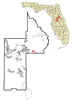 Location in Lake County and the state of Florida | |
| Coordinates: 28°48′28″N 81°33′49″W / 28.80778°N 81.56361°WCoordinates: 28°48′28″N 81°33′49″W / 28.80778°N 81.56361°W | |
| Country |
|
| State |
|
| County |
|
| Area | |
| • Total | 1.3 sq mi (3.4 km2) |
| • Land | 1.3 sq mi (3.4 km2) |
| • Water | 0 sq mi (0 km2) |
| Elevation | 69 ft (21 m) |
| Population (2000) | |
| • Total | 765 |
| • Density | 588.5/sq mi (225/km2) |
| Time zone | Eastern (EST) (UTC-5) |
| • Summer (DST) | EDT (UTC-4) |
| ZIP code | 32776 |
| Area code(s) | 352 |
| FIPS code | 12-66975[1] |
| GNIS feature ID | 0291330[2] |
Sorrento is a census-designated place and town in Lake County, Florida, USA. The population was 765 at the 2000 census. It is part of the Orlando–Kissimmee Metropolitan Statistical Area.
Geography
Sorrento is located at 28°48′28″N 81°33′49″W / 28.80778°N 81.56361°W (28.807872, -81.563571).[3]
According to the United States Census Bureau, the CDP has a total area of 1.3 square miles (3.4 km2), of which, 1.3 square miles (3.4 km2) of it is land and 0.04 square miles (0.10 km2) of it (1.53%) is water.
The City is an unincorporated part of Lake County and is a part of the environmentally sensitive Wekiva River Basin. The majority of the area lies along State Road 46 lying between Mt. Dora and Sanford. Mt. Plymouth is also considered a part of Sorrento.
Demographics
As of the census[1] of 2000, there were 765 people, 269 households, and 203 families residing in the CDP. The population density was 591.2 people per square mile (229.0/km²). There were 286 housing units at an average density of 221.0/sq mi (85.6/km²). The racial makeup of the CDP was 89.54% White, 0.78% African American, 0.78% Native American, 6.80% from other races, and 2.09% from two or more races. Hispanic or Latino of any race were 17.39% of the population.
There were 269 households out of which 36.8% had children under the age of 18 living with them, 57.6% were married couples living together, 11.2% had a female householder with no husband present, and 24.5% were non-families. 18.6% of all households were made up of individuals and 6.3% had someone living alone who was 65 years of age or older. The average household size was 2.84 and the average family size was 3.23.
In the CDP the population was spread out with 28.6% under the age of 18, 8.9% from 18 to 24, 32.4% from 25 to 44, 20.4% from 45 to 64, and 9.7% who were 65 years of age or older. The median age was 35 years. For every 100 females there were 104.5 males. For every 100 females age 18 and over, there were 103.0 males.
The median income for a household in the CDP was $39,318, and the median income for a family was $41,343. Males had a median income of $25,845 versus $17,101 for females. The per capita income for the CDP was $17,569. None of the families and 2.2% of the population were living below the poverty line, including no under eighteens and 15.1% of those over 64.
References
- 1 2 "American FactFinder". United States Census Bureau. Retrieved 2008-01-31.
- ↑ "US Board on Geographic Names". United States Geological Survey. 2007-10-25. Retrieved 2008-01-31.
- ↑ "US Gazetteer files: 2010, 2000, and 1990". United States Census Bureau. 2011-02-12. Retrieved 2011-04-23.
Municipalities and communities of Lake County, Florida, United States | ||
|---|---|---|
| Cities | 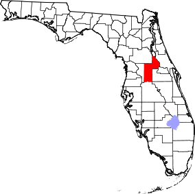 | |
| Towns | ||
| CDPs | ||
| Unincorporated communities |
| |
| Footnotes | ‡This populated place also has portions in an adjacent county or counties | |