Sleman Regency
| Sleman Regency Kabupaten Sleman | ||
|---|---|---|
| Regency | ||
| ||
| Motto: Sembada | ||
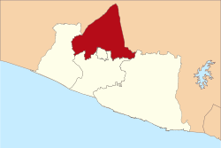 Sleman Regency in Special Region of Yogyakarta | ||
| Coordinates: ID 7°34′51″S 107°15′03″E / 7.58083°S 107.25083°ECoordinates: ID 7°34′51″S 107°15′03″E / 7.58083°S 107.25083°E | ||
| Country | Indonesia | |
| Special Administrive Region | Yogyakarta | |
| Incorporated | 8 August 1950 [1] | |
| Capital | Sleman | |
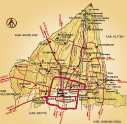
| Kecamatan[2] |
List
| |
| Government | ||
| • Regent | Sri Purnomo [3] | |
| Area | ||
| • Total | 574.82 km2 (221.94 sq mi) | |
| Population (2010 Census) | ||
| • Total | 901,400 | |
| • Density | 1,600/km2 (4,100/sq mi) | |
| Time zone | WIB (UTC+7) | |
| Post Code | 55500, 55200 | |
| Area code(s) | +62 274 | |
| Vehicle registration | AB | |
| Regency bird | Orange-headed thrush [4] | |
| Regency plant | Salak pondoh [5] | |
| Website |
www | |

Sleman (Indonesian pronunciation: [səˈleman]) is an Indonesian regency (Indonesian: Kabupaten) on the island of Java. It is located in the north of the Yogyakarta Special Administrative Region, Indonesia, and has an area of 574.82 square kilometres (221.94 sq mi),[6] with a population of 901,400 at the 2010 Census.[7] Its capital is the town of Sleman. The current regent is Sri Purnomo.
History
Pre-Incorporation
During the 8th century, the Buddhist Sailendra dynasty controlled Sleman, building numerous temples such as Kalasan.[8] The palace itself was at Ratu Boko.[9]
After the fall of the Sailendra dynasty, the Mataram Kingdom ruled over Sleman, taking control of Ratu Boko palace and eventually commingling with the remnants of the Sailendra dynasty.[9]
The Sanjaya dynasty, which replaced the Mataram kingdom, later ruled over Sleman and is believed to have built Prambanan c. 850 CE.[10]
Post-Incorporation
Sleman was incorporated on 8 August 1950 with the passing of the Law of the Republic of Indonesia Number 15 1950 about the Creation of Regencies within the Special Region of Yogyakarta.

In 2010, numerous eruptions of Mount Merapi and the cold lahar floods afterwards killed 353 people[11] and caused over Rp. 5.5 trillion (US$ 610 million) in damages.[12]
Geography
Sleman is located on the northwest border of Yogyakarta Special Region, between the city of Yogyakarta and the Magelang Regency. It is bordered by Central Java to the north and east, Kulon Progo, Bantul, and Yogyakarta to the south, as well as Gunung Kidul to the south-east. Mount Merapi is located on the northeastern border of the regency.
Administration
The regency of Sleman is divided into seventeen districts (kecamatan), tabulated below with their 2010 Census population.
| Name | Population Census 2010 |
|---|---|
| Moyudan | 30,883 |
| Minggir | 29,263 |
| Seyegan | 45,049 |
| Godean | 65,890 |
| Gamping | 96,720 |
| Mlati | 101,031 |
| Depok | 181,490 |
| Berbah | 50,787 |
| Prambanan | 46,857 |
| Kalasan | 76,158 |
| Ngemplak | 58,950 |
| Ngaglik | 101,887 |
| Sleman | 62,762 |
| Tempel | 49,312 |
| Turi | 33,101 |
| Pakem | 34,669 |
| Cangkringan | 28,201 |
Climate
Sleman features a tropical monsoon climate. The regency features a lengthy wet season generally running from October until June and a short dry season that only covers the months of July, August and September. The Regency averages roughly 2200 mm of precipitation annually. Sleman experiences particularly heavy rainfall from November through April. Temperatures remain relatively constant throughout the course of the year, with average high temperatures at around 30 degrees Celsius and average lows at around 22 degrees Celsius. There is slight variation within Sleman. The northern areas, near Mount Merapi, are much cooler due to the higher altitude. The southern area has nearly the same climate as Yogyakarta, due to their proximity.
| Climate data for Sleman [13][14] | |||||||||||||
|---|---|---|---|---|---|---|---|---|---|---|---|---|---|
| Month | Jan | Feb | Mar | Apr | May | Jun | Jul | Aug | Sep | Oct | Nov | Dec | Year |
| Average high °C (°F) | 29 (84) |
29 (84) |
29 (85) |
31 (87) |
30 (86) |
30 (86) |
29 (85) |
30 (86) |
31 (87) |
31 (88) |
30 (86) |
29 (85) |
30 (86) |
| Average low °C (°F) | 22 (72) |
22 (72) |
22 (72) |
22 (72) |
22 (72) |
21 (70) |
21 (69) |
21 (69) |
22 (71) |
22 (72) |
22 (72) |
22 (72) |
22 (71) |
| Average precipitation mm (inches) | 350 (13.78) |
330 (12.99) |
310 (12.2) |
210 (8.27) |
120 (4.72) |
80 (3.15) |
40 (1.57) |
20 (0.79) |
30 (1.18) |
90 (3.54) |
220 (8.66) |
340 (13.39) |
2,180 (85.83) |
| Source: http://www.weatherbase.com/weather/weather.php3?s=35869&refer=&units=metric | |||||||||||||
Economy
Sleman is heavily agrarian. However, due to the expansion of Yogyakarta there are some areas that have been urbanized,[7] with malls, hotels, and supermarkets being built. Tourism is also being developed to take advantage of the numerous temples found in Sleman, as well as Mount Merapi.[15]
Agriculture
Due to ashfall from Mount Merapi and easy irrigation, the land in Sleman is very fertile. The soil is thick, with a favourable moisture capacity level. As such, rice yields are considerably high.[7] The area is also well known for its production of salak pondoh, which is also its official plant.[5]
Education
There are 29 universities that have campuses in Sleman,[7] including Sanata Dharma University, Gadjah Mada University, Atma Jaya University, Islamic University of Indonesia, Yogyakarta State University and Sunan Kalijaga Islamic University.
Tourism

Sleman is home to many temples, including Prambanan,[10] Sari,[16] Kalasan,[8] and Ijo.[17] As well as temples, there are ruins of an ancient palace, namely Ratu Boko.[9] These temples and ruins, thought to be remnants of the Buddhist Sailendra dynasty and the Hindu Mataram kingdom,[9] are all open to the public. However, Prambanan is the most popular for tourism, drawing thousands of local and foreign tourists each year.[18]
Sleman also has a number of tourist villages including Brayut and others.[19][20]
Due in part to the scenic view at the foot of Mount Merapi, ecotourism has become common in Sleman. One of the most common destinations is Kaliurang, a resort town located in the Pakem district.[21]
Sleman includes the Adisucipto International Airport within its boundaries. There are numerous hotels in Sleman, ranging from small homestays and inns to multi-star hotels. The higher-end, multi-star hotels are located mainly near the road between Yogyakarta and Surakarta, with homestays and inns scattered throughout the regency.

Sleman is home to several museums including:
- Monumen Jogja Kembali (Monument to the Recapture of Yogyakarta), known colloquially as Monjali), which is dedicated to the Indonesian National Revolution and located in the Ngaglik sub-district.[22]
- Affandi Museum, located in Depok sub-district, which if is the former home of and hosts many works of famous Indonesian painter Affandi.[23]
- Merapi Museum, which hosts exhibits pertaining to volcanology as a whole and Merapi in particular and is located within Pakem sub-district.[24]
- Museum Dirgantara Mandala, located within the Indonesian Air Force base near the airport. Exhibits include the history of the Indonesian Air Force as well as numerous planes, rockets, helicopters, and other military equipment.[25]
After the 2010 eruptions of Mount Merapi, the areas affected have become disaster tourist attractions.[26] Tourists come from around Indonesia to see the disaster area, either for leisure, to pay their respects, or reflection.[27]
References
- ↑ Established by Law of the Republic of Indonesia Number 15 1950 about the Creation of Regencies within the Special Region of Yogyakarta
- ↑ Map of the various kecamatan of Sleman. Retrieved on 8 February 2011.
- ↑ Official Web Profile of the Sleman Regent. Retrieved 8 February 2011. (Indonesian)
- ↑ Official government website on the regency bird. Retrieved 8 February 2011. (Indonesian)
- 1 2 Official government website on the regency plant. Retrieved 8 February 2011. (Indonesian)
- ↑ Location and Area of the Regency. Retrieved 8 February 2011. (Indonesian)
- 1 2 3 4 United Nations Centre for Regional Development, Executive Summary ITC Follow-up Projects in Indonesia (PDF), retrieved 2011-02-08
- 1 2 National Library of Indonesia. Kalasan Temple. Retrieved 9 February 2011.
- 1 2 3 4 National Library of Indonesia. Ratubaka Temple. Retrieved 9 February 2011.
- 1 2 National Library of Indonesia. Prambanan Temple. Retrieved 9 February 2011.
- ↑ "Indonesia Downgrades Mount Merapi's Danger Level". The Jakarta Globe. 2 December 2011. Retrieved on 8 February 2011.
- ↑ "Bill From Merapi’s Wrath Rp 7.4t – and Climbing". The Jakarta Globe. 6 February 2011. Retrieved on 8 February 2011.
- ↑ Numbers are from southern Sleman, northern Sleman tends to be up to 7 °C (13 °F) cooler
- ↑ Weatherbase data for Yogyakarta city, directly to the south of Sleman. Retrieved 8 February 2011.
- ↑ Oxford Business Group. "Economic Update: Transparency in Sleman" 8 March 2006. Retrieved on 9 February 2011.
- ↑ National Library of Indonesia Sari Temple. Retrieved 9 February 2011.
- ↑ National Library of Indonesia. Ijo Temple. Retrieved 9 February 2011.
- ↑ Made Arya Kencana. "Borobudur, Prambanan Temples Praying for Bali Tourism Boost". The Jakarta Globe. 16 October 2010. Retrieved on 9 February 2011.
- ↑ (12 February 2014). Yogyakarta intensifies village tourism promotion, Antara (news agency)
- ↑ (3 January 2004). Sleman, home of a thousands tourist villages, The Jakarta Post
- ↑ R. Syah. "Kaliurang – Tour a la Madam and Meneer". Yogyes.com. Retrieved 8 February 2011.
- ↑ R. Syah. "Monumen Jogja Kembali (Monjali) – The Track of Six-Hours Occurrence in Yogyakarta". Yogyes.com. Retrieved 8 February 2011.
- ↑ Yunanto Wiji Utomo. "Affandi Museum, Visiting the Palace of a Maestro". Yogyes.com. Retrieved 8 February 2011.
- ↑ Sparks Fly at Volcanology Museum. The Jakarta Globe. 15 June 2010. Retrieved 8 February 2011.
- ↑ "Menilik Perjalanan Perjuangan TNI AU". Kompas. 30 March 2008. Retrieved on 8 February 2010. (Indonesian)
- ↑ "After Eruption, Indonesia Turns to Disaster Tourism". The Jakarta Globe. 16 December 2010. Retrieved 8 February 2011.
- ↑ "Indonesian disasters draw tourist dollars". Agence France-Presse, reprinted in the Jakarta Globe. 7 February 2011. Retrieved on 8 February 2011.
External links
- Official website (Indonesian)
- Sleman Tourism
Regencies and cities of the Special Region of Yogyakarta | ||
|---|---|---|
Capital: Yogyakarta | ||
| Regencies | ||
| Cities | ||