Sijung County
| Sijung County 시중군 | |
|---|---|
| County | |
| Korean transcription(s) | |
| • Hanja | 時中郡 |
| • McCune-Reischauer | Sijung kun |
| • Revised Romanization | Sijung-gun |
| Country | North Korea |
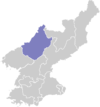
| Province | Chagang Province |
| Administrative divisions | 1 ŭp, 16 ri |
| Area | |
| • Total | 606 km2 (234 sq mi) |
| Population (1991 est.) | |
| • Total | 33,600 |
Sijung County is a kun, or county, in Chagang province, North Korea. It borders Kanggye and Changgang to the east, Manpo to the north and west, and Wiwon to the south. Formerly part of Kanggye, Sijung became a separate county in 1952 as part of a general reorganization of local government.
The terrain of Sijung is steep and mountainous in the east, where the Kangnam Mountains rise, but slopes downward toward the west. The highest point is Sirubong in the south, at 1355 m above sea level. The Changja River flows through north through the county, making a number of spectacular sharp twists on its way to join the Yalu. A portion of this has been dammed to create a large reservoir.
Sijung is served by both road and rail, with the Manpo Line stopping in the county. The Changja River reservoir is also used to ship some goods by water. Local industry is dominated by agriculture and mining.
See also
External links
- (Korean) In Korean language online encyclopedias: