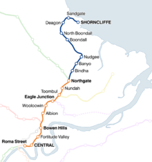
Shorncliffe railway line
| Shorncliffe line | |
|---|---|
 | |
| Overview | |
| Website | queenslandrail.com.au |
| Technical | |
| Line length | 11 km (6.8 mi) |
| Track gauge | 3 ft 6 in (1,067 mm) |
| Operating speed | 100 km/h (62 mph) |


The Shorncliffe railway line is an 11 kilometres (6.8 mi) suburban railway line situated north of Brisbane, the state capital of Queensland, Australia. It is part of the Queensland Rail City network.
History
The Sandgate Railway, opened in 1882, was the first truly suburban railway in Brisbane, built to provide convenient access to the seaside for the city's residents.[1] The terminus was originally named Sandgate and was renamed Shorncliffe in 1938.[2][3] The current Sandgate station was originally named Sandgate Central. The line allowed Brisbane residents to travel to Moreton Bay's shoreline at Shorncliffe.[4]
Duplication was completed by December 1901.[5]
Trains to Sandgate originally travelled via what is now the Exhibition line prior to the opening of the tunnel between Central and Brunswick Street in 1890.[6]
Line guide and services
Most services to and/from Shorncliffe continue onto the Cleveland line. The typical travel time between Shorncliffe and Brisbane City is approximately 33 minutes (to Central).
Passengers for/from the Caboolture and Nambour and Gympie North lines change at Northgate, Airport and Doomben lines at Eagle Junction, Ferny Grove line at Bowen Hills, and all other lines at Central.
| |||||||||||||||||||||||||||||||||||||||||||||||||||||||||||||||||||||||||||||||||||||||||||||||||||||||||||||||||||||||||||||||||||||||||||||||||||||||||||||||||||||||||||||||||||||||||||||||||||||||||||||||||||||||||||||||||||||||||||||||||||||||||||||||||||||||||||||||||||||||||||||||||
References
- ↑ Kerr, J. 'Triumph of Narrow Gauge' Boolarong Publications 1990
- ↑ "OPENING OF THE SANDGATE RAILWAY.". The Brisbane Courier. 1882-05-11. p. 3. Retrieved 2011-10-21.
- ↑ "SANDGATE STATION RENAMED". The Courier-Mail. 1938-10-21. p. 3. Retrieved 2011-10-21.
- ↑ Hallam, Greg (2005). Brisbane's Biography (Steamtrain Sunday). QR Limited.
- ↑ "Sandgate Duplication.". The Brisbane Courier. Qld. 1901-12-03. p. 2. Retrieved 2012-01-01.
- ↑ Kerr, J. 'Brunswick St, Bowen Hills & Beyond' ARHS 1988